15 February 2017
Researchers catch extreme waves with higher resolution modeling
Posted by Lauren Lipuma

In a new study, scientists present better predictions of how often extreme waves will hit. Their findings are important for coastal cities, the military, and industries that rely upon shipping and offshore oil platforms.
Credit: Jon Sullivan (PDphoto) via Wikimedia Commons.
By Sarah Yang
Surfers aren’t the only people trying to catch big waves. Scientists at the Department of Energy’s Lawrence Berkeley National Laboratory (Berkeley Lab) are trying to do so, too, at least in wave climate forecasts.
Using decades of global climate data generated at a spatial resolution of about 25 square kilometers (10 square miles), researchers were able to capture the formation of tropical cyclones, also referred to as hurricanes and typhoons, and the extreme waves that they generate. Those same models, when run at resolutions of about 100 kilometers (60 miles), missed the tropical cyclones and the big waves up to 30 meters (100 feet) high.
Their findings, published in Geophysical Research Letters, a journal of the American Geophysical Union, demonstrate the importance of running climate models at higher resolution. Better predictions of how often extreme waves will hit are important for coastal cities, the military, and industries that rely upon shipping and offshore oil platforms. And, of course, for surfers.
“It’s well known that to study tropical cyclones using simulations, the models need to be run at high resolution,” said Ben Timmermans, a computational scientist at Lawrence Berkeley National Laboratory in Berkeley, California and lead author of the new study. “The majority of existing models used to study the global climate are run at resolutions that are insufficient to predict tropical cyclones. The simulations in our study are the first long-duration global data sets to use a resolution of 25 kilometers [16 miles]. It’s also the first time a study has specifically examined the impact of resolution increase for ocean waves at a global climatological scale.”
Zooming in to detect hurricanes
Climate models work by simulating the exchange of air, water, and energy between the grid “boxes.” In today’s state-of-the-art climate models, these boxes are typically 100 to 200 kilometers (60 to 120 miles) wide. That level of detail is good enough to catch the formation and movement of midlatitude storms, the researchers said, because such systems tend to be quite large.
In contrast, tropical cyclones tend to cover a smaller area. While the overall footprint of a hurricane can be broad, the eye of a hurricane can be very compact and well defined, the researchers noted.
“The problem with that 100-kilometer [60-mile] resolution is that it misses key details of the hurricanes and tropical cyclones, which are clearly relevant to the generation of extreme waves,” said Dáithί Stone, a computational scientist at Berkeley lab and co-author of the study. “But going to a 25-kilometer [16-mile] resolution data set is computationally challenging. It requires 64 times more computational resources than a 100-kilometer simulation.”
The study relied upon the data-crunching power of the National Energy Research Scientific Computing Center (NERSC), a scientific computing user facility funded by the DOE Office of Science and based at Berkeley Lab.
The researchers ran the Community Atmosphere Model version 5 (CAM5) climate model with data collected in three-hour increments at a low resolution of 100 kilometers and at a high resolution of 25 kilometers (16 miles). They found that the high-resolution simulations included tropical cyclones where the low-resolution ones did not.
Crunching data to catch big waves
To see if the cyclones had an effect on waves, they then ran global wave models at both resolutions. They saw extreme waves in the high-resolution model that did not appear in the low-resolution ones.
“Hurricanes are tricky things to model,” Stone said. “We’ve shown the importance of using a high-resolution data set for producing hurricanes. But the characteristics of hurricanes could change with the climate. People are making projections of changes in ocean waves in a future, warmer world. It’s not clear if the 25-kilometer [16-mile] resolution is sufficient for capturing all of the processes involved in the development of a hurricane. But we do know that it’s better than 100 kilometers [60 miles].”

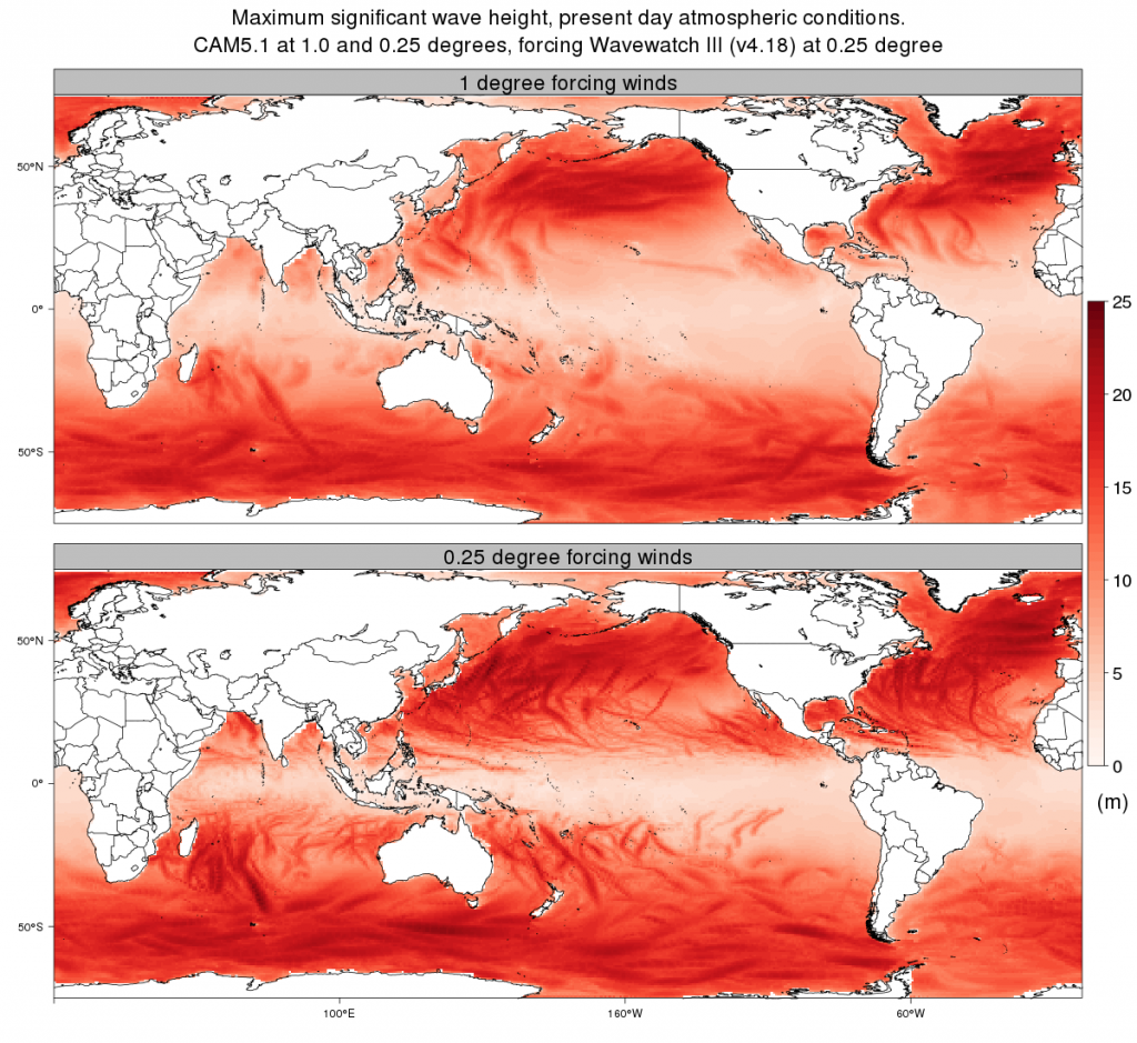
The maximum wave height in the time series above show differences in storm characteristics, including the presence or absence of tropical cyclones, when different resolutions are used. At resolutions of 25 km (16 miles) (bottom panel), the dark storm track lines are much narrower and more frequent, particularly in areas such as the central and western Pacific where tropical cyclones are influential. Many of these storm lines are wider or even absent in the 100-km (60-mile) case (top panel).
Credit: Ben Timmermans/Berkeley Lab.
While additional high-resolution simulations of the future are on the way, the researchers were able to take a first look at possible conditions at the end of the 21st century. The biggest waves in Hawaii are projected to be substantially larger in a much warmer future world, according to the authors.
The researchers added that this study only looked at averages of wind-generated waves. One-off “rogue” or “freak” waves cannot be reproduced in these kinds of models, and large waves such as tsunamis are very different since they are caused by seismological activity, not the wind.
The data from this study will be made freely available for use by the wider scientific community.
“In the same way that weather patterns are part of the climate, ocean wave patterns are also part of the ‘wave’ climate,” Timmermans said. “Ocean waves are relevant to the interaction between the ocean and the atmosphere, which affects the planet’s climate as a whole.”
—Sarah Yang is a science writer at Lawrence Berkeley National Laboratory. This post originally appeared as a press release on the Berkeley Lab website.


 GeoSpace is a blog on Earth and space science, managed by AGU’s Public Information staff. The blog features posts by AGU writers and guest contributors on all sorts of relevant science topics, but with a focus on new research and geo and space sciences-related stories that are currently in the news.