
10 February 2017
Daily disturbance from upper atmosphere leaves its footprints on tropical rainfall
Posted by Nanci Bompey
By Rachel Lentz
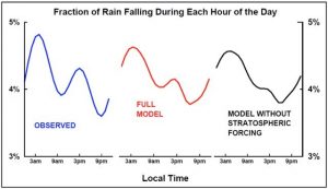
Fraction of the total rainfall, as a function of time of day, for a region including much of Indonesia and its surrounding oceans. Observations show strong peaks at early morning and mid-afternoon. IPRC modeling captures the observed modulation only when upper atmospheric forcing is included.
Credit: Takatoshi Sakazaki
No matter where you live, rain seems to fall more often at certain times of day, whether it is seen in the daily afternoon rainstorm or a typical overnight shower. Indeed, statistically, long-term average rainfall tends to cluster at certain times of the 24-hour cycle, but that time frame varies depending on location.
A team of scientists led by postdoctoral researcher Takatoshi Sakazaki, from the University of Hawaiʻi at Mānoa’s International Pacific Research Center (IPRC), has analyzed satellite-based observations and computer model simulations of tropical rainfall variation throughout the day in an effort to determine the root cause of the temporal patterns. Their results, accepted for publication in Geophysical Research Letters, a journal of the American Geophysical Union, show that daily tropical rainfall distribution is significantly shaped by heating of the upper atmosphere.
Continental settings often receive their peak rainfall in the late afternoon, after sunlight has heated the land surface throughout the day. Conversely, in tropical ocean settings, the maximum rainfall comes in the late night/early morning. In fact, detailed examination of observed tropical patterns reveals that rainfall often clusters into two uneven peaks, separated by roughly 12 hours, a pattern reminiscent of the familiar twice-daily ocean tide heights.
In fact, the atmosphere also experiences a type of daily tide. It has been long recognized that a global-scale pressure wave passes through the upper atmosphere, forced by the daily cycle of sunlight heating the ozone layer and propagating down towards the land surface. In the tropics, this wave can be seen in the daily fluctuations in barometric pressure, which peak at about 10 am and 10 pm.
Sakazaki and his team speculated that the tropical rainfall patterns are also intimately tied to this sun-driven atmospheric wave. By modeling rainfall patterns both with and without the forcing by upper atmospheric heating, they were able to show that the double peak of rainfall abundance in many tropical locations is accounted for only if the 12-hour atmospheric wave is included.
“It is exciting to find that rainfall has distinct ‘footprints’ of the stratospheric ozone heating, which occurs very far above us,” said Sakazaki. “Weather at the ground may be influenced by a much higher layer of the atmosphere than previously thought.”
Kevin Hamilton, a collaborator on this project and retired IPRC Director, noted, “Understanding the self-organization of rainfall over periods of hours to days, and over large distances, is critical for improving forecasts of our day-to-day weather in the tropics.” In addition, he emphasized that this strong link between the rainfall patterns and the atmospheric tides provides a unique feature whose presence, or absence, can be used to evaluate the accuracy of rainfall pattern forecasting in atmospheric models.
— Rachel Lentz is a Science Writer/Communications Specialist at the University of Hawaiʻi Sea Grant College Program & Pacific Islands Climate Science Center (PI-CSC) & International Pacific Research Center (IPRC). This post originally appeared on the IPRC website.


