22 May 2014
Snow photos sought to illuminate snowmelt puzzle
Posted by Nanci Bompey
By JoAnna Wendel
WASHINGTON, DC – In some places, where trees protect snow from sun and wind, it actually melts faster than in open areas. That’s what scientists concluded recently when they did a review of global data about snowmelt. Now, to gather much more data needed to deeply understand the discovery, and to make it useful for land and forest management, those same scientists are reaching out to an unlikely pool of collaborators: hikers, forest managers and other outdoors enthusiasts throughout the Pacific Northwest. They’re asking those outdoors lovers to send them geotagged photos of snow from forests across the region.
For the Pacific Northwest, snowpack is important for more than just recreation—spring and summer snowmelt can provide up to 80 percent of stream flow depending on the area, which is important for freshwater resources and salmon habitats. In recent years, scientists have noticed that snowmelt is starting earlier and earlier, which has large implications for this vital resource.

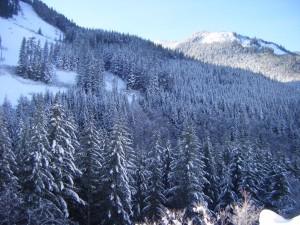
A forest in the Cedar River Watershed on the western slope of the Cascade Range in Washington state. Researchers at the University of Washington have found that snow protected by trees melts faster than in open areas and are now working to model the timing of snowmelt throughout the Pacific Northwest with the help of citizen scientists.
Credit: Susan Dickerson-Lange
There are many factors other than temperature that can influence snowmelt, and one of those factors is whether the snow falls on dense forest or open spaces. Susan Dickerson-Lange, a PhD student at the University of Washington in Seattle, along with other researchers in the Department of Civil and Environmental Engineering’s Hydrology Research Group, had begun to question whether snowpack lasts longer in the open versus in the forest.
It seems intuitive that snow shielded by dense forest cover from wind and the sun’s heat would stick around after other snow was gone from open areas where it’s exposed to the elements. In places like Colorado and the interior of British Columbia, this is true. But Dickerson-Lange and her colleagues found that, in places like the Pacific Northwest, where warmer winter temperatures are common, forests actually accelerate snowmelt, and open areas retain snow longer.
“Whether folks think that the snow lasts longer in the forests or in the open depends on where they grew up,” said Dickerson-Lange.
Trees, like the Earth itself, give off long-wave radiation—i.e. heat—which can affect their surroundings. In warmer winter temperatures, the warming from trees trumps their protective power.
“There’s so much interest in this timing [of snowmelt] for the future, so we would like to know how forests contribute to that,” said Dickerson-Lange.
The thickness of snowpack and timing of snowmelt is exceedingly complicated to predict, but remarkably easy to observe. Dickerson-Lange and her colleagues have several sites where they can observe and track snowmelt, but the Pacific Northwest is a big place, and they’ll need much more data to create a useful model.
And because the Pacific Northwest is already crawling with outdoors enthusiasts, Dickerson-Lange and her colleagues figured a citizen science campaign would be the perfect way to gather as much data as they could. The citizen science campaign, launched at the beginning of April, will provide important data to researchers who are investigating the timing of snowmelt, which has been starting earlier as the climate warms.

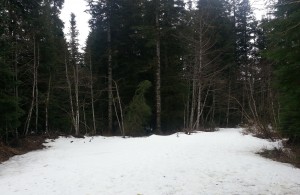
A forest near Mount Baker in Washington state shows snow-covered open areas and little snow in areas protected by trees. Researchers at the University of Washington are calling on citizen scientists to help them gather more data about how snow in the forest melts.
Credit: Andrew Gault
Dickerson-Lange and her team are encouraging hikers, forest rangers or land management specialists to take geotagged photos of areas that feature both dense forest and open spaces—forest gaps, clearings, meadows—and email them in. A geotagged photo is a photo that has been synced with GPS to track its exact position. Some digital cameras come with GPS synchronization and most smartphones these days have GPS built in (but it has to be enabled). When the photo is downloaded onto a computer, the user can look at its properties and see the geotagged data.
With just a geotagged photo, Dickerson-Lange can extract a wealth of important data, such as latitude, longitude, elevation, timestamp, and she can look at how much snow different areas have. As more and more photos come in, especially in populated areas, Dickerson-Lange may be able to see how one area changes through time.
So far, Dickerson-Lange has received few photos. But as the weather warms up and hikers start hitting the hills, she’s hoping more photos will come flooding in. With enough data, Dickerson-Lange is hoping to create a regional model that can be used for land and forest management purposes in the coming years of more unpredictable climate conditions. But first, she has to quantify how snowmelt is accelerated or retained by dense forest.
“Learning how to run a citizen science campaign is a learning process, but we’re getting there,” said Dickerson-Lange.
For more information and a short training video, see: http://depts.washington.edu/mtnhydr/research/citsci.shtml
JoAnna Wendel is a staff writer for the AGU’s weekly newspaper, Eos. She primarily writes research spotlights: short summaries highlighting exciting research from AGU journals


 GeoSpace is a blog on Earth and space science, managed by AGU’s Public Information staff. The blog features posts by AGU writers and guest contributors on all sorts of relevant science topics, but with a focus on new research and geo and space sciences-related stories that are currently in the news.