
27 February 2017
NIWA maps huge submarine landslides triggered by the Kaikoura earthquakes
Posted by Dave Petley
NIWA maps huge submarine landslides triggered by the Kaikoura earthquakes
NIWA, the National Institute of Water and Atmospheric Research in New Zealand, has put out a press release today regarding submarine landslides triggered by the Kaikoura earthquakes. We know that the main shock, and the aftershocks, triggered large numbers of landslides onshore. The picture on the seafloor was less certain, and is of course harder to determine. The interesting aspect of this is that offshore Kaikoura lies a submarine canyon – the Kaikoura Canyon – which is rather beautifully depicted in this NIWA press release from 2011:
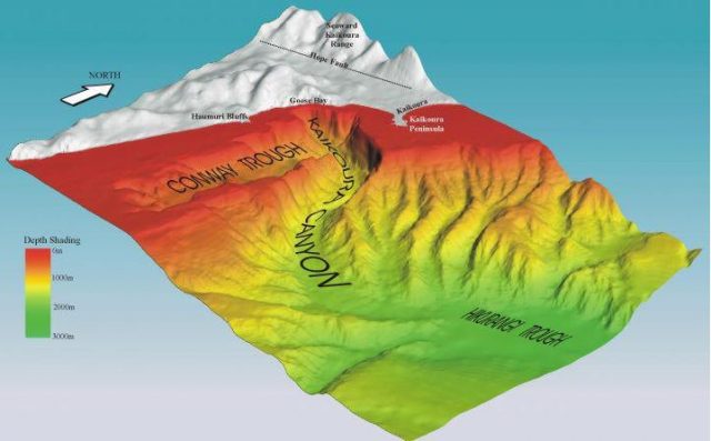
The Kaikoura Canyon, via NIWA
.
The interest in this canyon, and hence in its landslides, is more than merely academic. As the 2011 press release notes:
The Kaikoura Canyon is one of the most productive benthic (ocean floor) deep-sea habitats yet described, exceeding by 100 times the highest biomass measured for large invertebrates in at depths below 500 m at similar habitats, except for around hydrothermal vents. This productivity may contribute significantly to the surrounding ecosystem, which includes deep commercial fisheries for hoki and orange roughy.
The research showed very dense populations of large invertebrates, burrowing sea cucumbers, spoon worms, bristle worms and irregular urchins at depths of 900-1100 m.
It is this biodiversity that attracts the whales for which Kaikoura is known. The impact of large submarine landslides in the canyon is thus of critical importance.
NIWA have undertaken two research cruises to the canyon since the Kaikoura earthquake. They have found evidence of large landslides through the canyon:
…the latest post-quake surveys found not one instance of an organism living on or in the seabed. NIWA marine geologist Dr Joshua Mountjoy said a huge slipping event caused by the earthquake had removed the mud – where organisms had flourished – from the canyon’s upper slope.
“[Previously] everything at the head of the canyon was smooth and draped in mud. Our new data shows … almost every part of the upper slope had mud removed from it.”
The amount of material that had cascaded through the canyon was massive, he said.
“Some individual landslides are more than three times the size of the landslides that damaged the road to the north of Kaikōura.”
NIWA have released a before and after image of the landslides:
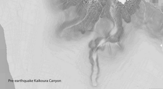
Pre-earthquake image of Kaikoura Canyon, via NIWA
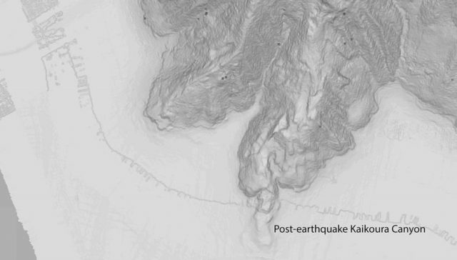
Post earthquake submarine landslides in the Kaikoura Canyon, via NIWA
.
Whilst the scale on these images is absent (which is frustrating), the amount of change is clear. It will be interesting to see how an inventory of submarine landslides compares with one for the terrestrial environment. I am not sure that such a comparison has been made previously. Others will be able to comment on the short and long term implications for marine organisms.
 Dave Petley is the Vice-Chancellor of the University of Hull in the United Kingdom. His blog provides commentary and analysis of landslide events occurring worldwide, including the landslides themselves, latest research, and conferences and meetings.
Profiling the slide run-out in the near term should be informative regarding stratification and consolidation, and applicable in determining the scale and date of other marine slides, perhaps?