
19 December 2014
My latest paper: Patterns of movement at the Ventnor landslide on the Isle of Wight
Posted by Dave Petley
The Ventnor landslide
One of the most interesting landslides in the UK lies under the town of Ventnor, which is located on the southern side of the Isle of Wight in southern England. This is a large, slow moving landslide that nonetheless causes considerable damage, particularly in periods of accelerated movement. Over quite a long period, the Isle of Wight Council worked with Halcrow (now CH2M HILL) to understand the landslide by monitoring its movement patterns. In recent years I have worked with a part time PhD student, Jon Carey (who is now at GNS Science in New Zealand), and Roger Moore at Halcrow, to understand the relationships between the movement of the landslide and pore water pressures. That work is a part of Jon’s PhD thesis (which is available online), and has just been published in the journal Landslides (Carey et al. 2014).
Perhaps the most interesting aspect of this landslide is a large graben structure that is opening up at the crest of the landslide. This is one of the figures from the paper, showing a geomorphological map of the landslide together with, bottom left, the graben structure:
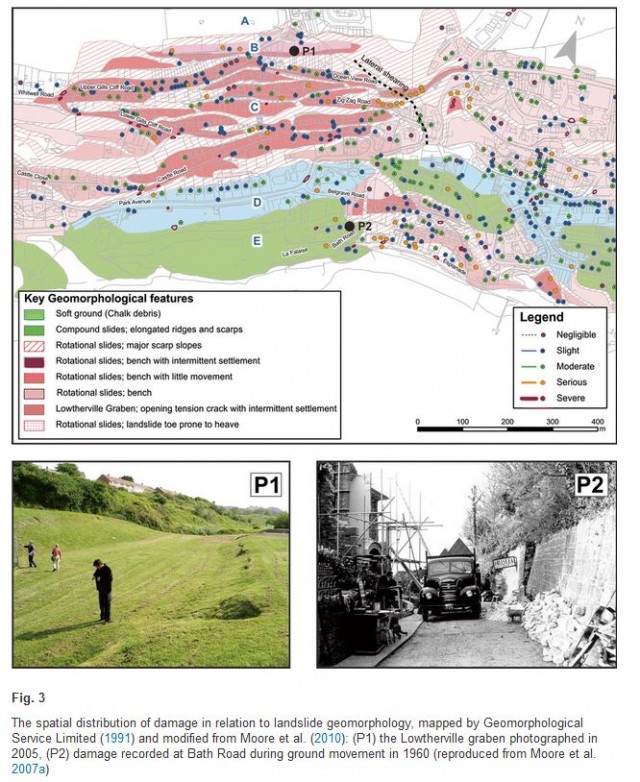
Figure 3 from Carey et al. (2015). Copyright Springer
.
In the paper we examined some very detailed monitoring data that was collected in a study led by our co-author, Roger Moore, between 1998 and 2002. During this time, Halcrow monitored the pore water pressure at depth using piezometers located in deep boreholes and the opening of the graben using crackmeters (to measure horizontal movements) and settlement cells (to measure vertical movements). We found that the movement of landslide can be divided into two key components. In the background is long-term creep of the landslide, at rates of about 5 to 10 mm per year, regardless of the groundwater conditions. This indicates that the landslide is in a condition of marginal stability / instability. However, when the groundwater level rises due to periods of heavy rainfall the landslide moves more rapidly – up to about 35 mm per year – but in a complex manner. This is captured in the diagram below, which is part of Fig. 6 from the paper:
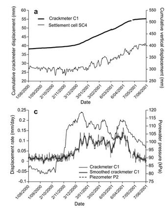
Part of Fig 6 from Carey et al. (2015). Copyright Springer
.
The upper panel of the diagram shows the movement of the landslide as indicated by extension of the graben sides and subsidence of the graben floor. The lower panel shows the same data for the crackmeter, but expressed as a displacement rate, and the measured groundwater level. It is clear that as the groundwater level increases the landslide movement rate goes up, and vice versa. However, across the entire dataset we found that the relationship between the pore water pressure and movement rate was not simple, and in particular that sometimes the movement rate remained elevated even as pore water pressures reduced.
At Ventnor there has long been discussion of the likelihood that the landslide might transition into a more rapid movement event. Our data suggests that because the landslide is occurring on a very well-developed basal shear plane, and because the toe of the landslide is buttressed by large landslide blocks, this is unlikely without some fundamental shift in material behaviour.
Reference:
Carey, J.M., Moore, R. and Petley, D.N. 2014. Patterns of movement in the Ventnor landslide complex, Isle of Wight, southern England. Landslides. doi: http://dx.doi.org/10.1007/s10346-014-0538-1
 Dave Petley is the Vice-Chancellor of the University of Hull in the United Kingdom. His blog provides commentary and analysis of landslide events occurring worldwide, including the landslides themselves, latest research, and conferences and meetings.
Hi there
My name is Mike & my partner & i are buying a house in ocean view road ventnor , please please could you tell me if its to risky as we can’t afford to lose everything we know up by steep Hill road is where the fault line is but that is different to the landslip isn’t it , any up to date news would be really great as its very hard to get information on it
Many thanks
Mike
[You will understand that I cannot give advice on any property. However, I think in general the risk to the vast majority of properties in Ventnor is low.]
Ocean View Road is directly below the graben. Having lived in Ventnor all my life I don’t recommend buying there.
Interestingly, we sold the property Mike was initially interested in purchasing but only after some stress. One particular surveyor included in his report that the house was leaning. A further structural report confirmed there was no subsidence but suggested historical settling. The door and window frames were all vertical as were the north/west and east facing walls. There were no visible cracks so I would suggest the house, which was semi detached was built that way. The afore mentioned ‘surveyor’, who is apparently well known for hating Ventnor (our estate agents words) also wrote that the house was un-mortgagable while the steep steps and lack of off street parking made it un-sellable. On top of that, IOW council ‘in their wisdom’, in light of a small landslip issue closer to the town upgraded the risk of subsidence for the whole of PO38 to HIGH.
This meant that a large area including the town itself was now at high risk of landslip. We sold it to a family who obtained a mortgage and now own a wonderful three bedroom house with amazing sea views.
In view of the massive slip December 2023, that has recently taken place in the Bonchurch area leading to the closure of Leeson road which is the main bus route and main road into Ventnor from Shanklin on the east side of Ventnor— , the IOW council have been proven right in their assessment of landslip risk
High levels of rainfall appear to have exacerbated what was already a big problem with regards to landslips and speed of earth movement as outlined in this article
Perhaps an update is now due to also include the falls near military road on the west side of Ventnor , as road closure there could be next
Used be called the dip
And shit house corner fyi
The reason the road at the graben has to be closed so often is, as is well know, to repair underground damaged service pipes etc. Has any thought been given to bringing the affected services above ground over the affected area where they could be seen and dealt with without excavation. The natural levels in the area would easily allow any gravitational requirements to be maintained The obvious pipes etc could surely be made a feature of in some architectural or artistic way to maintain reasonable appearance. With the technology available today it should be possible to go further and add some flexibility in any pipework and ducting. Just a thought.