26 July 2012
AGU Video: Impartial observers in space: Four decades of Landsat images both delight and inform
Posted by mcadams
[youtube=http://www.youtube.com/watch?v=beZEHPigTYk&feature=youtu.be&hd=1]
Perhaps you’ve seen them – crimson coastlines, magenta mountains, and other psychedelic views of the Earth from space. These eye-catching images of our home from above are thanks to the Landsat satellite program, which celebrated 40 years of Earth-surveying Monday.
We all know that ‘a picture is worth a thousand words,’ and in a world where most of us are bound to the Earth (astronauts being the most obvious exception), the Landsat images have the power to convey Earth science in a unique way. More than just pretty pictures, these images inform scientists, farmers, teachers, firefighters, water resource managers, and others about our planet from a vantage point several hundred miles above the Earth. The satellites, managed by both NASA and the U.S. Geological Survey (USGS), gave us images of New Orleans after Hurricane Katrina and views of the east coast of Japan after the 2011 tsunami. The satellites have also helped expose how humans are altering the planet, documenting the explosive growth of cities like Las Vegas and deforestation in Brazil.
“Both the public and law-makers are always looking for unbiased information to tell them how our planet is changing and how it changes in response to our decisions,” said USGS Director Marcia McNutt. “I think the beauty of Landsat is that it is an unbiased observer of our planet and it’s been telling us how [the planet] has been changing over the last 40 years. There’s no filter in how we present the Landsat data. It just is what it is.”
McNutt spoke with AGU after a briefing Monday, during which several scientists gathered with Congressional staffers in Washington, D.C., to reflect on the Landsat program’s 40-year legacy and contemplate its future. Four scientists presented evidence of how Landsat images have helped them to monitor crop yield, track land-use changes, and allocate water resources, among other applications.

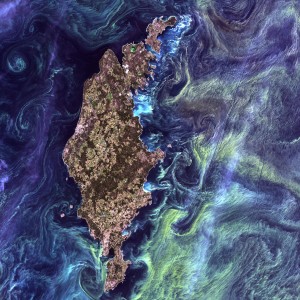
This image, titled ‘Van Gogh from Space’ because of its evocation of Van Gogh’s “Starry Night,” shows phytoplankton swirling in the waters around Gotland island in the Baltic Sea. The photo was selected by the public as the first place winner in the USGS “Earth as Art” contest, commemorating the Landsat Earth-observing program’s 40th anniversary. Photo credit: USGS/NASA.
“[These images] help us to better understand how much water is being applied to agricultural fields, particularly in the western states,” said Matthew Larsen, the associate director of Climate & Land Use Change at the USGS in Reston, Va. In the western U.S., where irrigation is common and water is scarce, states, counties and individual farmers sue each other over the resource. “It’s very important to have good information about how much water is being used by a field so that you can allocate water effectively,” Larsen said.
Philip Rasmussen, director of the Western Sustainable Agriculture Research & Education (SARE) Center at Utah State University, spoke of another way Landsat has helped farmers. In southeastern Idaho, Landsat images were used monitor wheat crops from above, allowing Rasmussen and colleagues to tell farmers exactly when and where to apply fertilizer to maximize protein content in their crops. Protein in wheat is extremely important for baking quality, Rasmussen said, because it helps bread to rise. High-protein wheat is therefore sought out by buyers. “[The farmers] got about 20 percent more income because they were able to maximize the protein of the wheat,” he said.
Though their efficacy as tools to inform scientists and the public is perhaps the primary use of Landsat images, the images also function as art thanks to some creative minds at the USGS Earth Resources Observation and Science (EROS) Center in Sioux Falls, S.D.
Thomas Loveland, a senior scientist at EROS, spoke after the briefing about the aesthetic aspect of the images. “My colleagues at EROS have systematically been pulling the images they think are the most interesting … [and] putting them through an image enhancement process that brings out the features of the Earth and colors that are appealing to the eye.”
Around a hundred such images have been collected over the last four decades. To celebrate this landmark anniversary, EROS put them to a vote in the “Earth as Art” contest, asking the public to decide the top five.
“These are images that have toured through museums around countries,” Loveland said. “It’s a collection that’s accessible to anybody. From the voting that went on, it was a real popular deal.”
The top five winners were announced Monday during a mid-morning press conference.
AGU joined with several other organizations to sponsor the Capitol Hill briefing on Monday evening.
– Mary Catherine Adams, AGU public information specialist


 The Plainspoken Scientist is the science communication blog of AGU’s Sharing Science program. With this blog, we wish to showcase creative and effective science communication via multiple mediums and modes.
It’s a very interesting article. Thank you for the information.