
21 January 2011
A symposium on seismically-induced landslides to mark the third anniversary of the Wenchuan earthquake

The 2008 Wenchuan earthquake in China remains the defining landslide event of the last three decades. To commemorate this event, the State Key Laboratory of Geo-hazard Prevention (SKLGP) at the Chengdu University of Technology are organising a symposium entitled:
An International Symposium on Earthquake Induced Landslides and Disaster Mitigation at the 3rd Anniversary of the Wenchuan Earthquake
This will take place in Chengdu, China from 11th to 15th May 2011, including two days of presentations and two days of field excursions to the earthquake-affected areas. Abstracts are due on 10th March 2011. Further details are available from: [email protected] or from the pdf linked here: 11_01 Chengdu conference
20 January 2011
A review of the Brazil landslides – Nova Friburgo
The lack of posts on this blog will not have passed unnoticed I am sure, and I can only apologise. Unfortunately, my day job is insanely busy at the moment, and I have no time for research, let alone blog posts. This will ease within a fortnight, if not before, so please be assured that the blog is not on the way to oblivion.
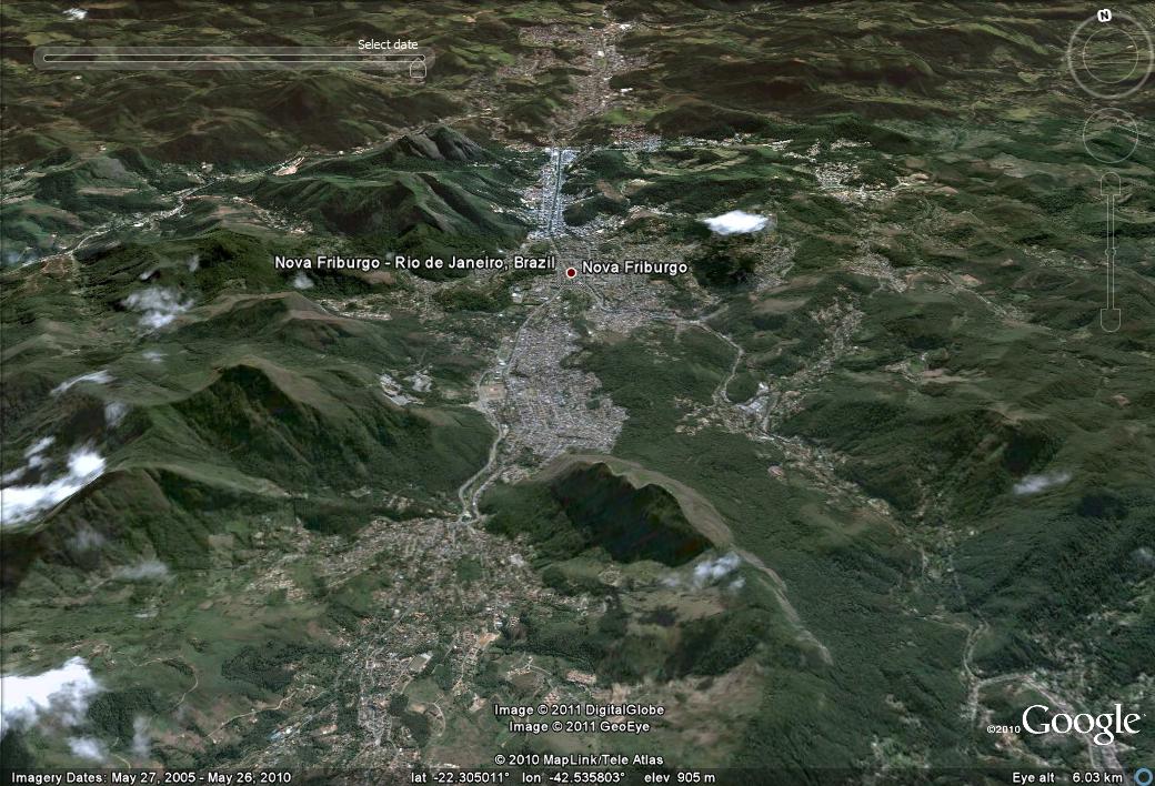
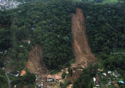
During my unfortunate lull in posts an extraordinary landslide disaster has of course unfolded in Brazil, killing at least 700 people, and possibly more than a thousand. The trigger has been very heavy rainfall associated with the current La Nina conditions, although the underlying cause is likely to be a combination of people living in the wrong places and damage to the environment as a result of human activities. The epicentre has been the three towns of Nova Friburgo, Teresopolis and Petropolis, located to the north of Rio de Janeiro. So let’s take a look at Nova Friburgo.
This is the Google Earth perspective view (dated March 2009) of Nova Friburgo – it is interesting because the landscape is not particularly high, though it is steep, and there are surprisingly few fresh landslide scars:
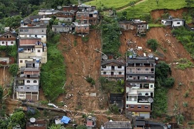
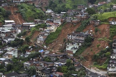
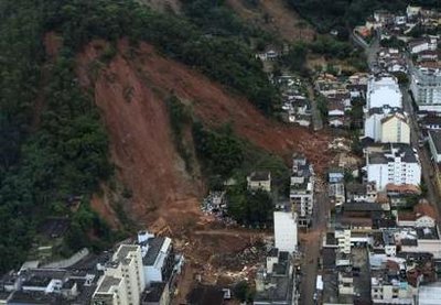
Inevitably the news reports and photos have focussed on the damage caused by the disaster rather than on the causes, but these news images are helpful:
 Source: AP
 Source: AP
 Source: AP
 Source: Reuters
 Source: Reuters
The news images tell us a fair amount about the landslides in Nova Friburgo at least. First, there are many (perhaps not surprising). Second, there appears to be two types of accidents occurring here. Some of the losses have been caused by direct hots by the landslides themselves. Most of these slides are long and narrow, extending most of the way up the slope. In rainfall induced landslides this is characteristic of failures that involve static liquefaction, which leads to rapid failure and high rates of movement. This is supported by the second to last image, in which the runout distance of the debris at the foot of the slope is quite long. It is unsurprising that the loss of life has been so high in areas affected by such slides. The second type is indicated by the very first image, which suggests multiple flow-type landslides in close proximity. Note here that the slides are both large and in some cases quite deep. However, there is almost no debris accumulated at the toe of the slopes, suggesting that it has moved rapidly down the watercourse. It is likely to have been this mechanism that created the devastating debris and mud flows that caused so much damage downstream.
There is also a rather impressive set of images of the disaster on this presentation (unfortunately I cannot find a way to embed authorstream files as yet – I am working on it!).
6 January 2011
Thursday round-up – landslides in the last week
Occasionally, I provide a round up of landslide events and news that has caught my eye in the last week. This is of course the low season for landslides worldwide, so fortunately the number of events is low:
1. Cliff collapse in Dover, UK
On 1st January there was a mild flurry of interest in concerns that a rockfall on chalk cliffs near to Dover in Kent, in SE. England, might have buried walkers on the beach below. A search team was deployed and the the all clear was quickly declared. The timing of the fall was interesting, given that the weather was neither wet nor stormy.
2. Fatal landslides in the Philippines
Heavy seasonal rainfall in the Philippines has triggered a number of landslides, especially in Southern Leyte. The toll included three children killed in St Bernard, well-known as the site of a huge landslide in 2006, and a woman killed by a landslide in the Mount Diwalwal area of Compostela Valley province. A landslide in Butuan reportedly killed two gold miners in a tunnel.
3. A fatal rockfall near the Mont Blanc tunnel entrance in Italy
On Sunday a French tourist was killed in Entreves in northern Italy when a boulder struck his car close to the Mont Blanc tunnel. The passenger in the car received minor injuries.
4. A fatal landslide in Brazil
Two girls were reportedly killed, with another missing, in a mudslide in Petropolis, Brazil.
5. A fatal landslide in Thailand
Early this morning a landslide killed a man in Khao Noi, in Songkla, Thailand. The slide buried a dwelling in which the owner was asleep.
5 January 2011
Google Ngrams – the use of the word “landslide”
Google now has about a million books online dating from 1500 to 2008. An interesting tool that they have provided, and which is great fun with which to play, is the NGram viewer, which allows the user to search for, and graph, the occurrence of specific words through time in these texts. Note that the data are presented as the use of the word as a percentage of the total words in the texts.
It is quite fun to compare the use of four different words describing natural hazards. This graph shows the occurrence of the words “earthquake”, “flood” and “volcano” from 1500 to 2008 in the “Google Million” set of English books:

The dataset starts very noisy and then becomes more stable, with a substantial increase in the use of the terms from about 1750 onwards. So lets focus on the period 1800 to 2008:

Notice how the use of the word “earthquake” has some large spikes, whereas “volcano” is smoother. I don’t know enough about the history of these terms and events to be able to interpret this, but compare the above with the same data for the use of the word landslide:
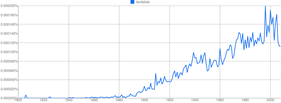
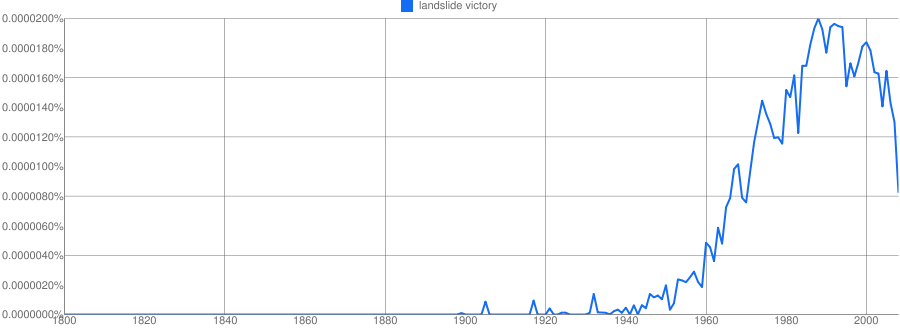
The pattern is completely different (and note that the axes scale is also rather different). The use of the word landslide started to increase from 1800 onwards, and appears to have risen essentially monotonically thereafter. There is a slight dip in the period from 1940 to 1950 (the effect of World War 2?), and the data for the term has become more noisy in recent years. This could of course be a reflection of the use of the term in the context of elections (i.e. “landslide victory” and suchlike), but a search for that specific term suggests not:
Finally, compare the term “landslide” with the older term “landslip”:
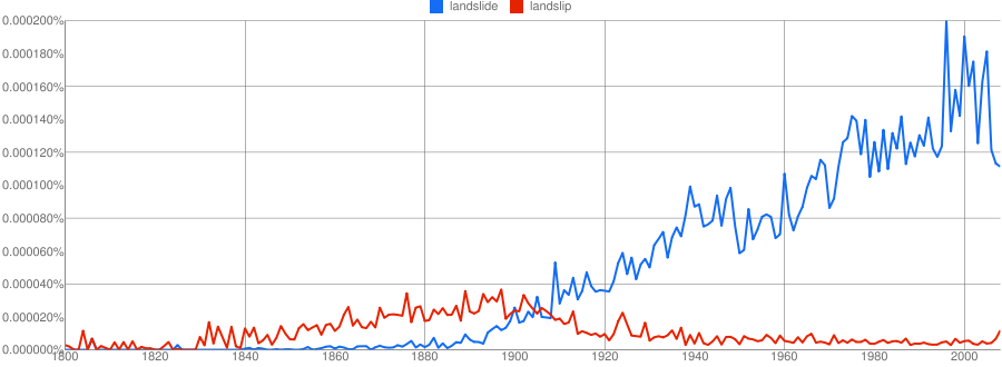
It is clear that the latter term was much more common than landslide through to about 1900, and that as the use of the term “landslide” became more frequent the use of “landslip” reduced markedly.
I’ll come back to Google Ngramsin a subsequent post to look at the use of landslide terminology in more detail. It is a pretty cool tool.
4 January 2011
Attabad – one year on
Today marks the anniversary of the Attabad landslide disaster that has so dominated the lives of the people of Hunza, N. Pakistan for the last year. I do not intend to revisit the event here – I have covered the events of the last 12 months in great detail, but there is a synthesis of the events in the second half of the paper below, which should be downloadable as a pdf:
The reference is:
Petley, D.N., Rosser, N.J., Karim, D., Wali, S., Ali, N., Nasab, N. and Shaban, K. 2010. Non-seismic landslide hazards along the Himalayan Arc. In: Williams, A.L., Pinches, G.M., Chin, C.Y., McMorran, T.J. and Massey, C.I. (eds) Geologically Active. CRC Press, London, pp. 143-154.
Meanwhile, the first anniversary is being marked in Pakistan with a number of events, with (rightly or wrongly) the tone being very much dominated by a sense of continued frustration at the local and national government response. Some coverage is provided in a newsy item the Express Tribune and a more reflective piece in the Daily Times. In Hunza itself today is being described as the “Black Day”, with extensive demonstrations planned, although the Pamir Times reports that the demonstrations have been banned. Other demonstrations are planned in Islamabad, but news these have not yet reached the news wires.
Unfortunately, both the chronic and the acute hazards associated with the lake remain. The same Pamir Times article states that boat movements on the lake have been banned for a month, presumably because of the ice, effectively isolating the upstream population once again. Meanwhile, the threat of an outburst flood remains, although we still have no way of knowing how acute this threat actually is at the current time, or in the summer ahead.
31 December 2010
The Attabad landslide continues to cause real hardship in Gojal
On 4th January it will be a year since the Attabad landslide blocked the Hunza Valley, generating Gojal Lake and generating real hardship amongst the local population. Of course we are now in mid-winter and the lake has frozen, adding further to the hardship of the local people. The Pamir Times has been providing coverage of the ongoing tribulations of the local people:
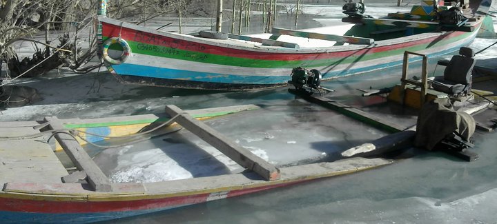
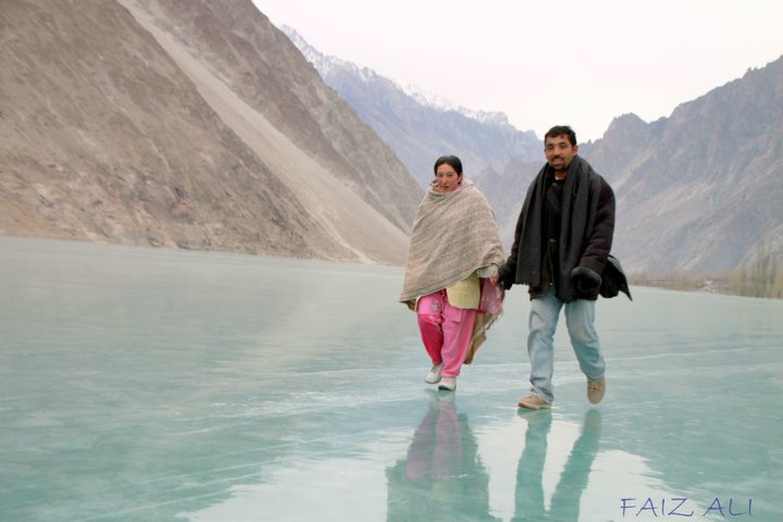
People walking across the surface of the frozen lake.
Needless to say there are very real perils associated with walking on the ice.
23 December 2010
Reports of landslides in California and Colombia
News reports coming out of Colombia this morning suggest that there has been yet another large landslide in that battered country. Colombia Reports is carrying a story that a landslide occurred yesterday in Santander Province in the north of the country. The landslide is reported to have struck a small hamlet between Rionegro and El Playon, destroying the a number of houses and reportedly burying 20 people. There’s not much news on this at the moment; hopefully more will emerge during the day.
Meanwhile, on the day that I finally left California yet another “Pineapple Express” rainstorm blew in, triggering floods and landslides across a wide area. I have been trying to collate a list of reported landslides:
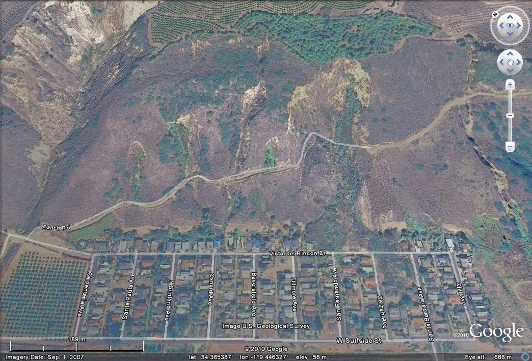
- La Conchita: This is probably the most infamous landslide site in recent years in the US, having been the site of two very large landslides in 1995 and then 2005. A further slide occurred here yesterday, not as large as the earlier events, but still substantial. The Daily Sound reports that the landslide was shallow but had a surface area of 12,000 square feet (about 1,100 square metres), whilst the Los Angeles Times reports that a geologist brought in to investigate the site has stated that the landslide is likely to move further. The Google Earth image below, taken before the slide yesterday, demonstrates clearly why there is such concern about this site:
- Green Valley Lake in San Bernadino has reportedly suffered from mudslides that have blocked the access roads, effectively isolating the community.
- Another landslide reportedly blocked a feeder road for Interstate Highway 10 at the transition to State Route 57 in the Pomona area, blocking three lanes of the road.
- The town of Highland in San Bernadino County has reportedly been hit by one or more mudslides, damaging 20 houses and burying many cars.
There are many others I’m sure. Please add more in comments and I’ll try to update the page.
22 December 2010
Book review – The Planet in a Pebble
 A couple of months I was approached by the publisher of this book, Oxford University Press, to ask if I would like a review copy and was intrigued. The premise of the book is remarkable – that it is possible to write an engaging popular science book based around the geology of a single pebble. And not an obviously fascinating pebble either – this is a piece of apparently dull, grey Silurian slate from Wales. This is the sort of piece of rock that most geologists would ignore on a stony beach – and indeed the publisher also appears to have had misgivings about the subject as the cover (pictured to the right) shows a pebble that is most certainly not Silurian slate. A slate pebble looks like the one pictured below. Ironically, this can also be a beautiful piece of rock, so I cannot understand why the publisher has used such a misleading (to the geologist at least) image.
So I started wondering how such a book came about. Was it a drunken conversation late one night on a field trip in deepest Wales (i.e. I imagine a cottage in the hills outside Lampeter, with a coal fire burning), in which the author and another geologist got into a bragging contest in which they tried to out-compete each other for who could write a successful popular geology book on the most obscure topic? Probably not, but if so, the author Jan Zalasiewicz, certainly set himself a tough task!
So, does it work as a popular science book? The answer is a remarkable and resounding yes. The book is fascinating and engaging, stretching from the earliest foundations of time, in which the matter that now forms the pebble was created, to modern day beach environments. Along the way the book describes the nature of modern geology, and in particular the detailed forensic investigations that are needed to piece together the history of our planet. In so doing, the book overturns the popular myth that geologists are essentially visual scientists, doing little more than interpreting features based on observation and simple logical rules. The great strength of the book is in the writing, which is at times beautiful, always engaging, and well-paced. There is no sense that the book ever stalls – so often a problem in popular science writing – and the author manages to express his own love and fascination for the discipline. I also appreciate the emphasis that the author placed on describing what we don’t know, as well as what we do. We still have so much to learn, and it is important to communicate that fact.
 That said, the book is not perfect, although the issues are perhaps niggles rather than major causes for concern. First, the author is correct in stating that humans love a story, but we also need visual information in order to understand properly. The book is under-illustrated, and those illustrations that are present are really rather weak and basic in comparison with the prose. Perhaps the idea is to produce a fully illustrated coffee table version in due course (now that would be a wonderful tome) but for now the book is let down a little by this weakness. The plates, in colour which is good, are frustrating in that the captions are at the start of the book. That meant that when I came to the crucial passages I found myself juggling between three different parts of the book, a most frustrating experience, if one that is good for developing hand-eye coordination skills! In addition, the photographs mostly lack a scale bar or any other visual clue as to size – poor practice that is always criticised at undergraduate level.
Second, the end of the book, which details the period in which the pebble reaches the surface and encounters modern environments, feels rushed and somewhat sketchy. Given that this is the environment in which we live, this is a shame. It probably reflects the author’s own geological background, which is understandable, but it leaves a section that really feels weak in comparison to the rest. And finally, in a couple of places the description of modern processes really feels a bit under-researched. For example, we now know that the generation of fractures in rock masses by ice comes not from freeze-thaw but from segregation, and the idea that waves cause cliff disintegration through the generation of air pressures in fractures also has the feel of high school science.
But these are minor criticisms. I would strongly recommend the book – if in the unlikely event that it was written as a bet then the author has undoubtedly won the prize. I would buy it as a Christmas present, but would want to be sure that the recipient is au fait with at least basic science. Jan Zalasiewicz undoubtedly has a talent for this type of writing, and I am sure many more books will follow. I would not hesitate to buy the next one, even if it is on an equally obscure topic.
Comments from anyone else who has read it are welcome – do you share my views?
21 December 2010
Community-based landslide warning systems
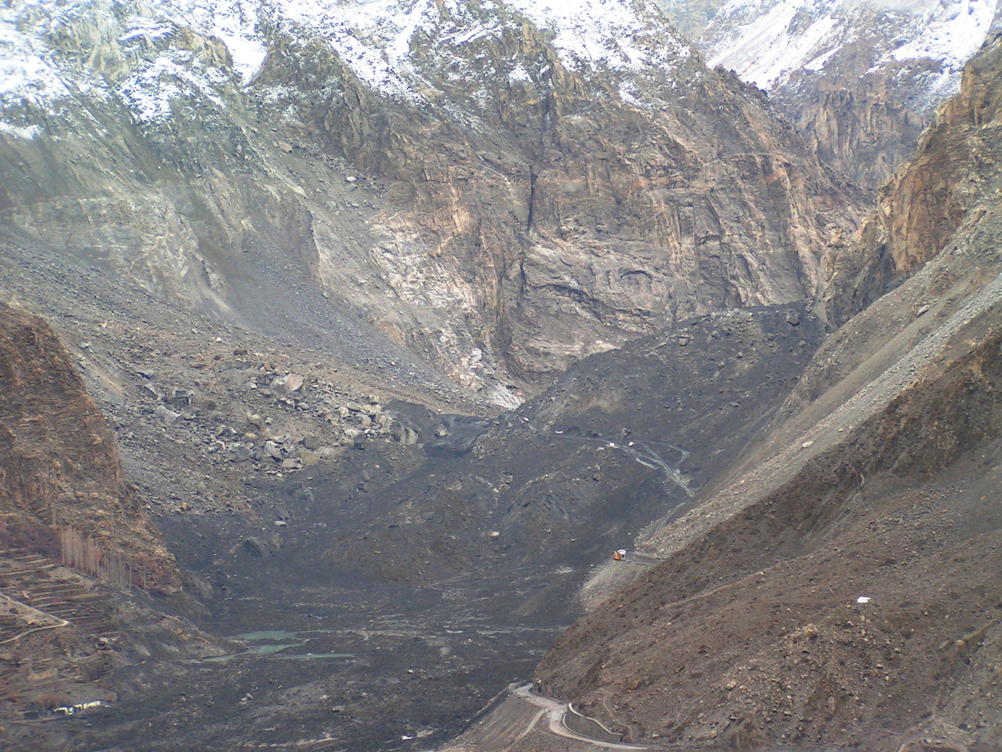
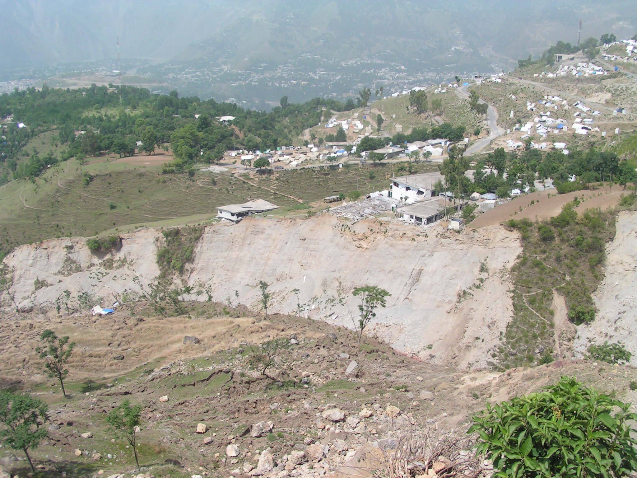
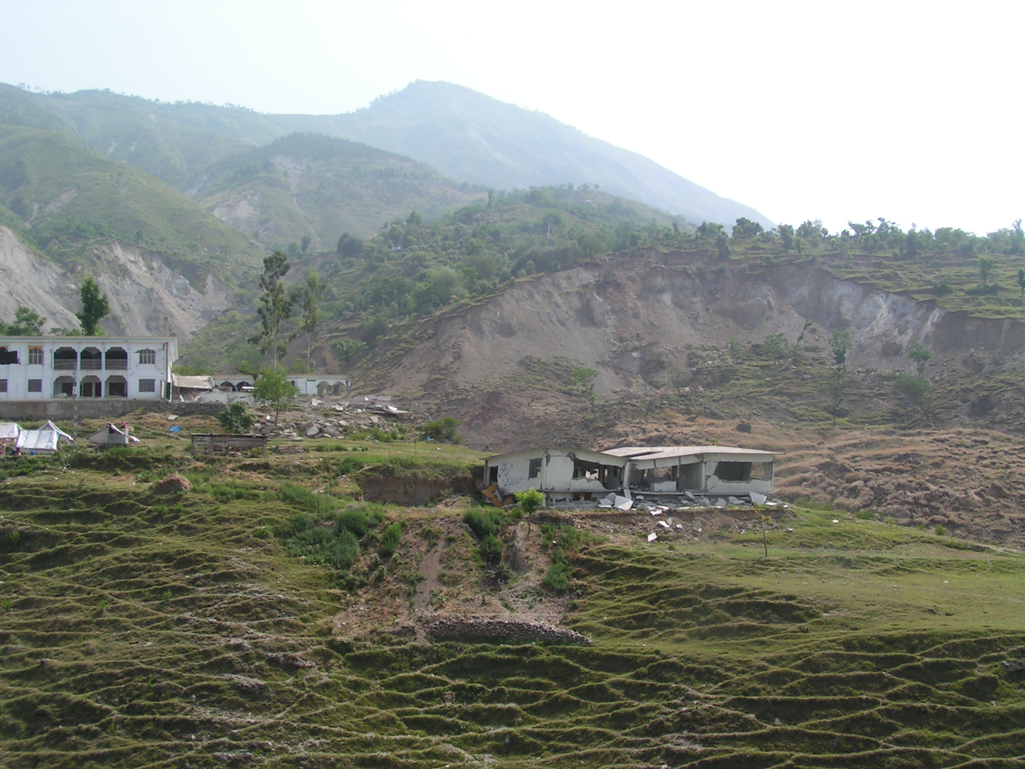 An increasingly important area of work in landslides is the development of tools to generate warnings to potentially-affected communities. Whilst technologically-led examples have been available for a couple of decades now, and have proven to be quite effective, the growing emphasis is on low tech approaches that can be operated by and within communities. This is entirely pragmatic – we know that most of the severe losses, whether measured in terms of lives lost or in proportion of per capita GDP, occur in less developed countries, particularly in Asia and Latin America. Unfortunately, the problems are so widespread, and in many cases so large that engineering-led mitigation is impossible, even if sufficient resource was available (and usually of course it is not). A good example appeared in the Pakistan media today, with reports of multiple locations across northern Pakistan in which active landsliding is affecting rural communities. Undoubtedly, communities in Pakistan are very sensitive to these issues at the moment, but the threats posed by landslides in these upland areas, especially in the context of climate change, are very real. (By way of illustration the two photos in this post are both communities affected by landslides in Kashmir, Pakistan).
A stock response to these threats is to suggest relocation of the population, but this is rarely a satisfactory approach. As I have noted before, poor people balance the risks in their lives in a rather sophisticated way. The immediate risks that people face are associated with access to clean water, sanitation, food, health care and education. Relocation may serve to reduce the risks associated with the landslide, but more often than not increases these more immediate risks, leaving the people worse off.
 Thus, a pragmatic solution is to try to develop warning systems. Of course these must be as reliable as possible, but they must also be based upon a technology that will work in the setting on which they are located. Critically, the warning system needs to be operated by the local population for two key reasons. First, a locally-run warning system is most likely to actually operate in the difficult conditions e.g. (heavy rainfall) that occur during a potential landslide. Second, local buy-in means that the system is more likely to be trusted and, in particular, it reduces the chances of the population growing weary of the inevitable false alarms. This requires that the system is essentially simple and understandable, and that a huge effort must be made to work with the local community to achieve buy-in.
A nice example of such an approach is provided in a media report from the Philippines today. Here, a World Bank funded project, undertaken with the Center for Initiatives and Researches on Climate Change Adaptation (CIRCA) and the University of the Philippines-Los Baños, has sought to develop a low tech community warning system for the town of Manito in Albay. The system is based upon the principle that a rainfall threshold can be identified at which point landslides start to become likely – this is the same basis for the sophisticated Hong Kong warning system. Recycled plastic bottles are used to measure rainfall, and manually-operated bells are used to provide the warning. Underpinning this is a training programme to ensure that local communities both understand the warning system and know how to react when the alert occurs. In addition, the education programme is designed to build environmental awareness within the community, thus addressing one of the chronic problems that increases landslide occurrence in rural villages.
I hope that we will see many similar initiaves over the next few years in rural communities, underpinned with sharing of successes and failures such that we can learn from each other. The combination of population growth, resource pressures and of course climate change is going to make this essential. And, just in case you believe the reports in the right wing press that the current high profile cold weather in Europe and parts of the US is an indication that climate change is at an end, the following two NASA maps are a remarkable wake-up call. The first map shows temperature for the last 12 months (i.e. December 2009 to November 2010, which of course includes the cold weather in Europe in the first part of 2010): measured against the longer term mean. Clearly red is above average and blue is below:
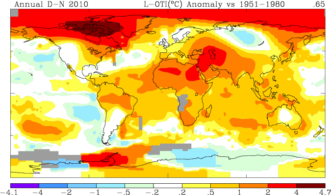
The second is the anomaly for November 2010:

Not many reasons to be cheerful there.
19 December 2010
The outcome of a study of the Kolontar Tailings Dam failure
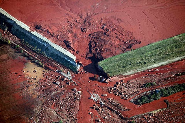
Regular readers will remember that I covered in a number of posts the tailings dam failure at Kolontar in Hungary, which flooded a town with bauxite waste with fatal consequences. At the time we tried to “crowd source” an interpretation of what had happened, and as a result we speculated that the failure might have resulted from a foundation failure of the dam caused by high pore pressures, which led to the dam lifting off its foundations, generating a rupture at the corner of the structure where the stresses were concentrated (image from Greenpeace):
Thanks to Caner Zanbak, Environmental Advisor to the Turkish Chemical Manufacturers Association, for making available a pdf of a presentation outlining the results of an investigation that he undertook of the failure. The presentation can be downloaded as a zip file below – note that the file contains only the pdf:
Caner has indicated in his presentation that the information in the presentation can be reproduced with acknowledgement. So what did he find?
Well, first the dam is built from fly ash, which behaves like a low quality concrete. Second, was constructed without proper foundations or a permeability barrier. Third, it notes, as we did here, that there were clear signs of seepage from beneath the dam in images taken in June 2010. Thus the author concludes that
“The dike failure was probably:
• Triggered by a shear failure in the dike at the seepage point located about 300 metres east of the northwestern corner of the impoundment, due to increased pore water pressures;
• Caused by separation of the north dike at the northwestern corner of the impoundment, and tensile fracturing in the easterly-displaced north dike segment; and
• was propagated by incremental eastern movement of the dike segment (west of the shear zone) where the fractured blocks in the northwestern corner of the dike were pushed out by the water in the impoundment causing the ultimate structural failure.”
The presentation finishes with a “moral of the story: “No leak/seepage is insignificant for retaining structures”, Good advice.
Thanks again to Caner for making this available. It not only helped with the understanding of this event, it also gave me something to look at whilst I kill the three days wait for my flight, thanks to the cancelation of my journey yesterday due to the snow in London.
 Dave Petley is the Vice-Chancellor of the University of Hull in the United Kingdom. His blog provides commentary and analysis of landslide events occurring worldwide, including the landslides themselves, latest research, and conferences and meetings.
Recent Comments