
30 May 2018
Seismometer readings could offer debris flow early warning
Posted by llester
Researchers decipher readings from January’s Montecito, California landslide to determine details of disaster’s scale and location
By Robert Perkins
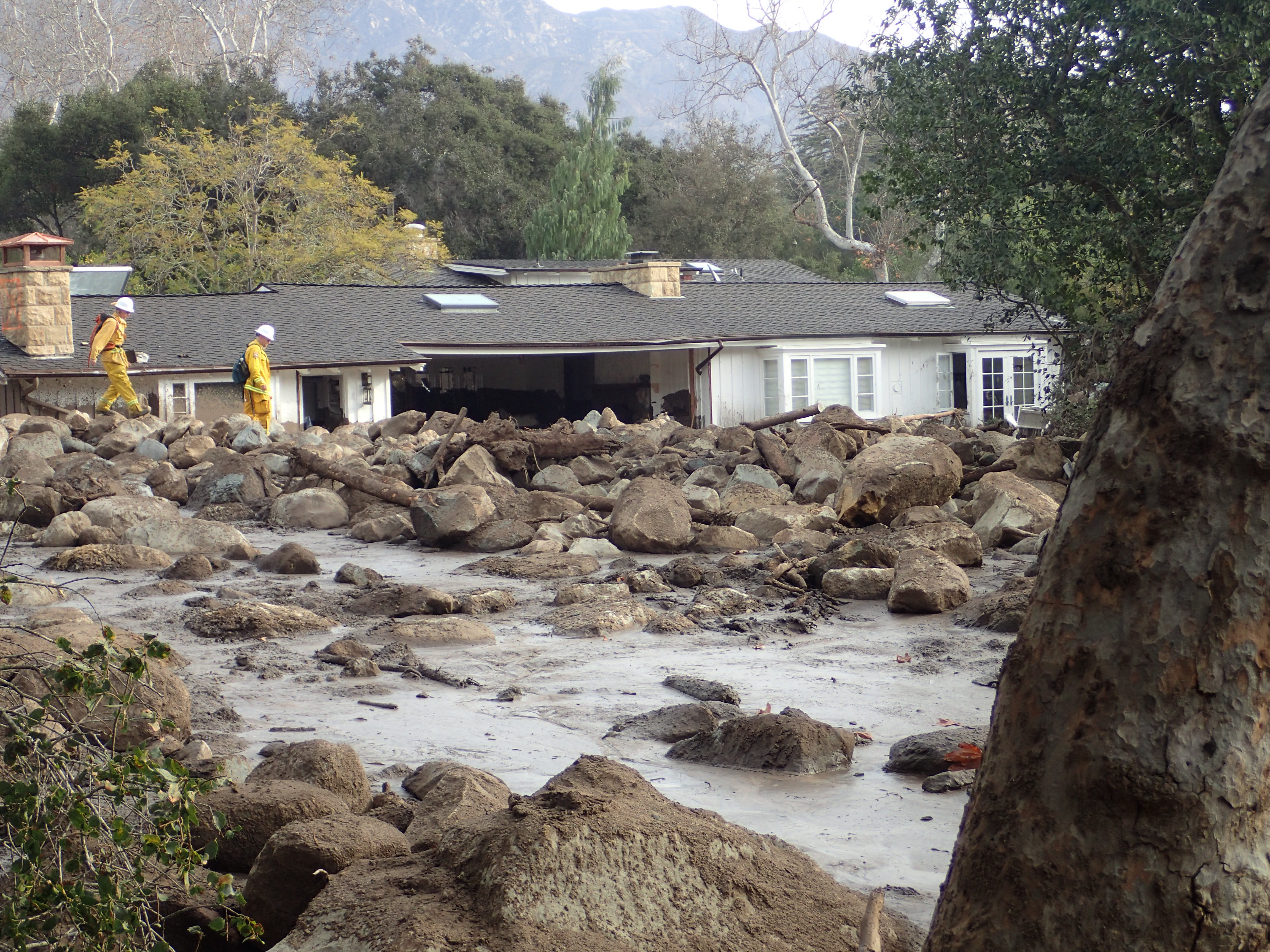
Damage from the January 2018 debris flow in Montecito, California.
Credit: USGS
First came the fire, then the rain—and finally, the devastating mud. In the wake of the largest wildfire in California’s history, the December 2017 Thomas Fire, a powerful storm dumped about 13 centimeters (5 inches) of rain on the denuded hillsides of Santa Barbara County, triggering debris flows on January 9 that killed 21 people and destroyed hundreds of homes in the Montecito and San Ysidro Creek areas.
Seismologists at Caltech noticed that the rumble and roar of the mudslide was detected by a seismometer about 1.5 kilometers (0.9 miles) away from the worst of the damage. They found that the seismogram generated by the event reveals information about debris-flow speed, the width of the flow and the size of boulders it carried, and the location of the event—results suggesting that the current generation of seismometers in the field could be used to provide an early warning of an incoming debris flow to residents in mudslide-prone areas.
Their study, which was published in Geophysical Research Letters, a journal of the American Geophysical Union, shows that seismometer readings could potentially have offered some of the residents of Montecito between 5 and 10 minutes of warning on January 9.
“The motion of the ground can indicate a lot of things, from the detonation of a warhead to the motion of a glacier. The trick is determining what the signal means,” said Victor Tsai, a geophysicist at Caltech and an author of the study. Tsai has long been interested in exploring what information can be gathered from seismometers beyond the usual earthquake signals they were designed to detect. He had already started working on a model that predicted what a mudslide should look like on a seismometer, based on existing models of sediment transported by water.
Caltech graduate student Voon Hui Lai gathered data from the three seismometers located within a few kilometers of the mudslide to search for the signal predicted by Tsai’s model. Due to proximity and technical issues, two of the seismometers did not robustly record the slide. The third, however, did. “It wasn’t immediately obvious, but after a while, we found it,” Lai said.
The signal, a rumbling lasting for nearly 20 minutes, showed up in the 5–10 hertz frequency band, which is at the lower threshold of human hearing. The team was able to determine that the signal was indeed the mudslide based on its timing and by ruling out other potential sources. It almost perfectly matched the predictions made by Tsai’s model. Tsai and Lai were further able to show how the signal could be used to estimate key elements of a debris flow (size, speed and intensity) based on how they influence the shaking of the ground.
The signal indicated that the debris flow “snout” (where the largest-sized boulders are) covered about a 50 meter by 50 meter (54 by 54 yard) area; that the boulders carried by the flow reached up to around 1.3 meters (1.4 yards) in diameter; and that the flow speed was about 2.4 meters (2.6 yards) per second.
“Debris flows move much slower than earthquakes, so we could potentially develop an early warning system that would offer important warnings for residents and first responders,” Tsai said, now that scientists know what to look for and have a model for what the seismogram is indicating.
“Like earthquakes, debris flows occur infrequently and are dangerous to observe directly,” said co-author Michael Lamb, a geologist at Caltech. “By measuring ground shaking at a safe distance, our study shows that seismology has great potential to improve our understanding of when, where, and why debris flows happen.”
The researchers plan to keep testing and fine-tuning the model using controlled experiments that yield more precise measurements.
—Robert Perkins is a content and media strategist at the California Institute of Technology. This post originally appeared as a press release on the California Institute of Technology website.
*Editor’s note: this blog post originally placed the mudslide following the Thomas Fire in the wrong county. The correct location is Santa Barbara County.


Interesting that the seismometer could pick up sound signals of the Earth’s vibrations caused by mud flows. Of course the seismometer can pick up earthquake signals from a great distance away. It sounds like that distance for mud flows would need a closer proximity to a seismometer station. Is the seismometer something that has to be permanently in the ground or could you have mobile units. This way you could place them in strategic locations around burned areas when weather conditions are more prevalent to mud flows. With earthquake signals being so fast, there isn’t much time for a given warning to go out for preparation. However, since mud flows seem to move at a slow rate of speed, it could give a little more time for exiting from potential hazard areas in time.