
30 September 2015
Gulf Stream ring water intrudes onto continental shelf like “Pinocchio’s Nose”
Posted by Nanci Bompey
By Stephanie Murphy

Satellite imagery shows the exchange of warm core ring water (red) with the colder continental shelf waters (blue). Satellite imagery, however, could not help scientists determine the underlying process for the warm water intrusion; instead they used data from ocean robots or “gliders” recently installed off the coast of Massachusetts. The scientists have dubbed the events “Pinocchio’s Nose Intrusions” (PNI) because the warm intruding water continues to “grow” for hundreds of miles, moving in the opposite direction from the northeastward movement of the Gulf Stream.
Credit: Jack Cook, Woods Hole Oceanographic Institution
Ocean robots installed off the coast of Massachusetts have helped scientists understand a previously unknown process by which warm Gulf Stream water and colder waters of the continental shelf exchange. The process occurs when offshore waters, originating in the tropics, intrude onto the Mid-Atlantic Bight shelf and meet the waters originating in regions near the Arctic. This process can greatly affect shelf circulation, biogeochemistry and fisheries.
In 2006, scientists using satellite imagery observed an elongated body of warm water from a Gulf Stream warm-core ring intruding along the shelf edge, extending hundreds of miles from Massachusetts towards Cape Hatteras, NC.
“A lot of people were surprised by this,” said Weifeng ‘Gordon’ Zhang, associate scientist at Woods Hole Oceanographic Institution (WHOI), and lead author of the study published today in Geophysical Research Letters, a journal of the American Geophysical Union. “Normally, the Gulf Stream water, which is very warm and buoyant, doesn’t come in direct contact with the water on the continental shelf, which is much colder. There is a cascade of potential implications that need further study.”
Until now, scientists had been unable to study the phenomenon because satellites can only sense the ocean surface, and no data about the structure of the intrusion water below the surface were available. However, in April 2014, water column data in this area became available from preliminary deployments from the National Science Foundation-funded Ocean Observatories Initiative (OOI). Specifically, autonomous vehicles called “gliders” that collect data along a pre-defined path in the ocean, were deployed at the OOI Pioneer Array site south of Cape Cod. Zhang and his colleagues used preliminary glider data, collected from April through June 2014 and publicly available on the OOI website, to generate the first profile of the complex, layered masses of water at this vital point in the ocean.
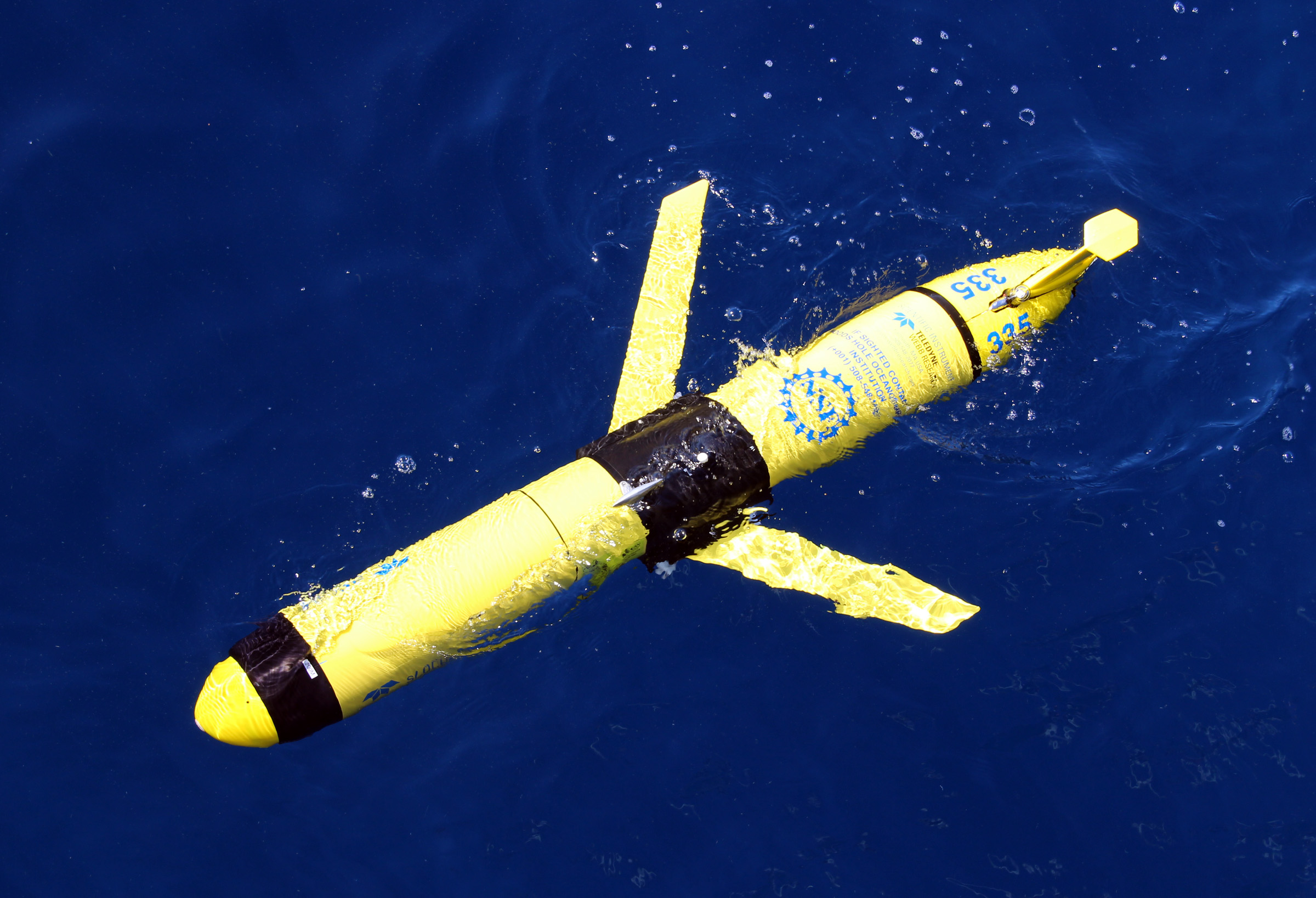
Autonomous vehicles called “gliders” collect data by swimming in a saw-tooth pattern along a pre-defined path in the ocean. The gliders were deployed at the OOI Pioneer Array site south of Cape Cod. Thanks to the data collected by the OOI Pioneer Array gliders before and after the PNI formed, the scientists determined these intrusions are nearly 100 meters deep, extending almost to the seafloor.
Credit: Al Plueddemann, Woods Hole Oceanographic Institution
“The edge of the continental shelf is a key location where dense, nutrient rich water ‘upwells’ to the surface, stimulating growth at the base of the food web,” said co-author Glen Gawarkiewicz, a senior scientist at WHOI. “This water is normally sandwiched between colder, fresher water on the shelf and warmer Gulf Stream waters offshore. Understanding changes in this region has important societal and economic implications.”
Satellite imagery shows five similar-looking intrusion events have occurred between 2007-2014 in the winter and spring seasons. Zhang and Gawarkiewicz have dubbed the events “Pinocchio’s Nose Intrusions” (PNI) because the warm water intrudes onto the shelf and continues to “grow” for hundreds of miles, moving in the opposite direction from the northeastward movement of the Gulf Stream.
Until this new research was conducted, one proposed explanation was that the warm waters were swept up in the shelf break jet, a current that moves toward the southwest direction along the shelf edge. Zhang calls this “the deception or lie” of the Pinocchio’s Nose Intrusion. “If the intrusion was caused by the shelfbreak jet,” said Zhang, “this feature would most likely be a very thin, superficial feature on the surface.” In contrast, thanks to the data collected by the OOI Pioneer Array gliders before and after the PNI formed, the scientists determined these intrusions are nearly 100 meters deep, extending almost to the seafloor.

The Pioneer Array is a coastal observatory that is part of the NSF-funded Ocean Observatories Initiative (OOI). It is moveable array of surface moorings, moored profilers and autonomous vehicles, including gliders, deployed along the “continental shelf-break” off the coast of southern New England, the boundary where coastal waters meet the open ocean. It is a dynamic intersection where ocean currents meet in weather-like “fronts,” and where the nutrients, pollutants, minerals, creatures, and waters of the coast are exchanged with the deep ocean. Zhang and his colleagues used preliminary glider data, collected from April through June 2014 and publicly available on the OOI website, to generate the first profile of the complex, layered masses of water at this vital point in the ocean.
Credit: Jack Cook, Woods Hole Oceanographic Institution
Rotating warm core rings form in the deep ocean and eventually pinch off from the Gulf Stream, heading in a northwest direction onto the shallower continental slope. The outer limbs of the rings hit the slope first, and are squeezed by the rising sea floor. Once reaching the shelf, they follow the shelf edge extending to the southwest forming the long nose shape. Eventually, the extension stops, and thin filaments coming out of the north side of the nose penetrate further onto the shelf.
The OOI Pioneer Array data also allowed scientists to understand the complexities of what is driving the density of the various water masses at this unique location. Under normal conditions, the density in the region is controlled by the salinity. The shelf water is fresher than offshore water and therefore more buoyant than saltier offshore water. However, during a PNI event, the shelf water is less buoyant than the offshore water because of a huge temperature difference—approximately 25-30 degrees Fahrenheit—between the shelf waters and the intrusion waters.
“Because the Gulf Stream water is so outrageously warm, density now is controlled by the temperature, and the intrusion water is more buoyant, despite being saltier,” said Zhang.
The changes in temperature, density and circulation all have major implications for the fisheries in the area.
“I showed the glider data to a group of commercial fisherman back in April, in Rhode Island, and they were very surprised,” said Gawarkiewicz. “They couldn’t believe the temperature can change by that much, that quickly.”
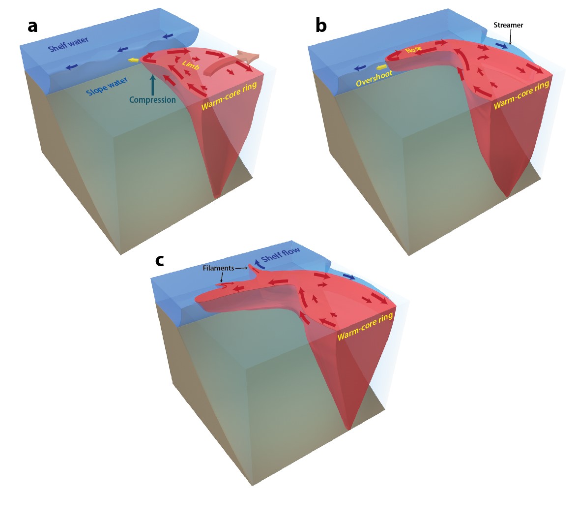
Rotating warm core rings form in the deep ocean and eventually pinch off from the Gulf Stream, heading in a northwest direction onto the shallower continental slope. The outer limbs of the rings hit the slope first, and are squeezed by the rising sea floor. Once reaching the shelf, they follow the shelf edge extending to the southwest forming the long nose shape. Eventually, the extension stops, and thin filaments coming out of the north side of the nose penetrate further onto the shelf.
Credit: Jack Cook, Woods Hole Oceanographic Institution
The scientists believe the PNI process might assist in the transport of young fish, like American eel, across the shelfbreak barrier and onto the shelf, where they can swim toward coastal estuaries. For American eels, this is an important step of their reproductive migration journey and crucial for their survival. The baby eels have to make it from the spawning ground in the tropics to their estuarine and freshwater habitats on the US northeast coast in the first year of their life. The direct intrusion of the Gulf Stream water onto the shelf can help them reach their destination without being swept away, and may increase their survival rate. But for other species, the intrusion might bring in the low nutrient Gulf Stream surface water and suppress the upwelling of cold, dense, nutrient-rich water, and thereby reduce biological productivity in a region that is otherwise known for its fertile fishing grounds.
“I just find it extraordinary that the Pioneer Array gliders were out for a month, and we have already identified a new shelf break exchange process,” said Gawarkiewicz. “It just goes to show how much more we have to learn in the shelf-wide ecosystem. And that’s why the Ocean Observatories Initiative is so important. We wouldn’t have been able to do this without their data.”
— Stephanie Murphy is the Manager of Public Information & Internal Communications at WHOI. This post originally appeared as a press release on the WHOI website.


