16 December 2014
Scientists use drones to monitor surf zone
Posted by kwheeling
By Leigh Cooper

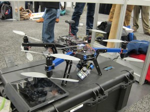
A drone the team will be using in the future. The team uses the drones to track pollutants, such as the oil released during the Deep Water Horizon oil spill in 2010.
Credit: Leigh Cooper
When ocean scientists visit the beach they pack more than sunscreen and a towel – they pack drones. Researchers show in a new study that drones can be used to cheaply and accurately monitor the movement of water in the surf zone in the Gulf of Mexico. The drones provide a new way of documenting the movement of plant and animal plankton, sediments and pollutants, including spilled oil, near the shore.
In the past, ocean scientists have used the EPA-approved dye Rhodamine to track the movement of ocean currents. Working from a boat, researchers spill the neon pink dye into the sea, where it becomes a passenger of the ocean’s currents. By monitoring the dye’s progression, “we look at how particles [like oil or other pollutants] from outside of the surf move into the surf zone,” said Ad Reniers, a marine physicist at Delft University of Technology, during a poster presentation Monday at the American Geophysical Union’s Fall Meeting in San Francisco.
But continuously monitoring the sinuous, rosy curves proves challenging. In the past, scientists recorded the pink plumes from a chartered – and expensive – plane, spotted the dye from nearby high ground, or use pre-placed sensors in the water.
Enter drones. It can take hours for the dye to work its way to the beach, and drones can cheaply and easily record the entire process. “Drones provide an inexpensive and versatile measuring platform that can be used quickly, making them ideal for complex coastal environments,” said Reniers.
“We can track the distance the dye travels and the speed the dye travels into the near-shore,” said Reniers. (Watch a documentary of a flight).
Because the drones’ batteries only last for about 10 minutes before they need to recharge, the team flew two drones in shifts – one landing as the other took off. The team launched the drones over the Gulf of Mexico near Destin, Florida for three weeks in December 2013.

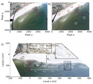
(a) An image from a drone. (b) The squares are the blue tarps, and the circles are the boogie boards. (c) A geo-rectified image.
Credit: Patrick Rynne and Ronald Brouwer
The scientists wanted to generate accurate images of the landscape using the drone technology. They first had to fix image distortion caused by the fisheye lenses in the drones’ GoPro Hero 3+ cameras. Then, the team measured distances in the study area using GPS locations of blue tarps placed on the beach and boogie boards anchored in the ocean. The bright items are easily located on the drone images, and the team corrected the photos to accurately represent the distances between the tarps and boogie boards.
Once the images were rectified, the scientists picked out 100 pictures of the same beachfront and compressed them into one single image. By layering the images together, general water movement trends arose.
The condensed photo identified where waves broke continuously – white fuzzy areas – and the location of rip current channels – clear blue canals squeezed between the white waves. Because waves only break in shallow areas, the scientists could pinpoint the location of sand bars. Along some beaches, the exchange of near-shore water and offshore water differs greatly depending on near-shore topography. The amount of water movement is an important determinant of beach degradation if the team is tracking the spread of offshore pollutants. The photos also provided a safety assessment for swimmers by isolating dangerous rip currents.
Other groups have tried to use drones to map near-shore currents, but they have run into problems with winds. But, the team’s drones (a 3D Robotics Y6 and an Aerialtronics Altura AT6), which can be ordered from robotics companies, meandered from their waypoint by only a few meters in winds just over 20 mph if steered by an experienced pilot.
In the future, the team hopes the technology will be used to measure storm damage, because drones can be launched quickly and easily. “You can see it as rapid response. You can have a quick look and see what’s going on,” said Reniers.
The group also wants to add a lidar sensor, a remote sensing technology that uses reflected laser light to measure distance, to their drones. “It’s very exciting. You could look into the impact of sea level rise with the lidar since you get very intricate topographic information,” said Kyle Cavanaugh, a marine ecologist with the University of California, Los Angeles, who was unaffiliated with the new study.
– Leigh Cooper is a science communication graduate student at UC Santa Cruz.


 GeoSpace is a blog on Earth and space science, managed by AGU’s Public Information staff. The blog features posts by AGU writers and guest contributors on all sorts of relevant science topics, but with a focus on new research and geo and space sciences-related stories that are currently in the news.