24 May 2018
Subglacial valleys and mountain ranges discovered near South Pole
Posted by llester
By Andrea Slowey

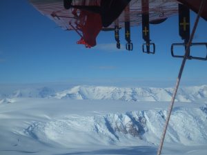
A British Antarctic Survey Twin Otter Aircraft collects ice-penetrating radar data over the Transantarctic Mountains near the South Pole to learn about the physical features of the bedrock underlying the ice. Credit: Tom Jordan, British Antarctic Survey
Researchers have discovered mountain ranges and three huge, deep subglacial valleys from data collected during the first modern aerogeophysical survey of the South Pole region.
The findings are the first to emerge from extensive ice-penetrating radar data collected in Antarctica as part of the European Space Agency’s PolarGAP project and have been published in Geophysical Research Letters, a journal of the American Geophysical Union. The data reveal the bedrock topography, which controls how quickly ice flows between the East and West Antarctic ice sheets.
The team has mapped for the first time three vast, subglacial valleys in West Antarctica. These valleys could be important in future as they help to channel the flow of ice from the center of the continent towards the coast.
If climate change causes the ice sheet to thin, these troughs could increase the speed at which ice flows from the center of Antarctica to the sea, raising global sea levels.
“We now understand that the mountainous region is preventing ice from East Antarctica flowing through West Antarctica to the coast. In addition, we have also discovered three subglacial valleys in West Antarctica which could be important in the future,” said the study’s lead author, Kate Winter of Northumbria University.
“If the ice sheet thins or retreats, these topographically-controlled corridors could facilitate enhanced flow of ice further inland, and could lead to the West Antarctic ice divide moving. This would, in turn, increase the speed and rate at which ice flows out from the center of Antarctica to its edges, leading to an increase in global sea levels.”

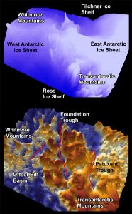
A 3D image of the Patuxent Trough, Foundation Trough, and Offset Rift Basin, three large valleys under the ice near the South Pole, created from the data recorded in the PolarGAP survey. Credit: Tom Jordan, British Antarctic Survey
The largest valley, known as the Foundation Trough, is more than 350 kilometers long (217 miles) and 35 kilometers (22 miles) wide. Its length is equivalent to the distance from London to Manchester, while its width amounts to more than one and a half times the length of New York’s Manhattan Island.
The two other troughs are equally vast. The Patuxent Trough is more than 300 kilometers (186 miles) long and over 15 kilometers (9 miles) wide, while the Offset Rift Basin is 150 kilometers (93 miles) long and 30 kilometers (19 miles) wide.
Although there are extensive satellite data that help image the surface of the Earth and its deep interior, there was a gap around the South Pole area, which is not covered by satellites due the inclination of their orbits. The PolarGAP project was therefore designed to fill in the gap in the satellite data coverage of the South Pole and acquire the missing gravity data.
“As there were gaps in satellite data around the South Pole, no one knew exactly what was there, so we are delighted to be able to release the very first findings to emerge from the PolarGAP project,” Winter said. “The data we have gathered will enable ice sheet modellers to predict what will happen if the ice sheet thins, which will mean we can start to answer the questions we couldn’t answer before.”
Winter worked with researchers from Newcastle University, British Antarctic Survey, the Technical University of Denmark, the Norwegian Polar Institute and the European Space Agency on the paper, “Topographic steering of enhanced ice flow at the bottleneck between East and West Antarctica.”
“Remarkably the South Pole region is one of the least understood frontiers in the whole of Antarctica,” said Fausto Ferraccioli of the British Antarctic Survey, an author of the study and the principal investigator of the PolarGAP project.
“By mapping these deep troughs and mountain ranges we have therefore added a key piece of the puzzle to help understand how the East Antarctic Ice Sheet may have responded to past change and how it may do so in the future. Our new aerogeophysical data will also enable new research into the geological processes that created the mountains and basins before the Antarctic ice sheet itself was born,” Ferraccioli said.

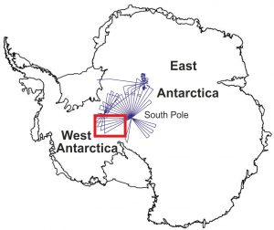
A map of the region surveyed by PolarGAP. The red box marks the location of the 3D figure. Credit, Tom Jordan, British Antarctic Survey.
“Understanding how the East and West Antarctic Ice Sheets interact is fundamental to our understanding of past, present and future global sea level. These new PolarGAP data give us both insights into how the landscape beneath the ice influences present ice flow, and a better understanding of how the parts of the great Antarctic ice sheets near to South Pole can, and cannot, evolve in response to glaciological change around their margins,” said author Neil Ross of Newcastle University.
“There is a need to follow up the extensive aerogeophysical PolarGAP survey with detailed field investigations and numerical modelling of the glaciological processes operating in this frontier region of Antarctica.”
—Andrea Slowey is a public relations and media manager at Northumbria University. This post originally appeared as a press release on the Northumbria University website.


 GeoSpace is a blog on Earth and space science, managed by AGU’s Public Information staff. The blog features posts by AGU writers and guest contributors on all sorts of relevant science topics, but with a focus on new research and geo and space sciences-related stories that are currently in the news.
Interesting. First, this article reminded me to think of the South Pole and Antarctica as a continent and not just as an ice sheet. Second, that there are land features as mountains and valleys, not just a flat land mass. What could cause these land masses to form? Then, I remind myself about Pangaea. When Pangaea was a super continent, Antarctica was in a completely different geological position on the Earth. In this geological position, geological forces would have prevailed to form the present mountains and valleys. To think about how the glacial forces could drastically affect the Antarctica land mass in its present form currently is one thing, but how that effect is on the Earth as a whole in the future is something altogether.