29 December 2016
Scientists test less invasive methods of locating oil in deep sea
Posted by Lauren Lipuma
By Teresa L. Carey
New techniques for finding oil beneath the seafloor could reduce the frequency of seismic testing or exploratory drilling, which is harmful to marine animals, according to new research.
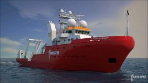
Marine mammals rely on their hearing ability to navigate, find mates and locate feeding grounds. Exploratory drilling and seismic testing can expose these animals to deafening sounds that compromise that ability. But a new technique developed by scientists at Fugro Marine GeoServices, Inc. in Houston, Texas, uses sonar and software to help oil explorers locate sites with a higher likelihood of oil more quickly, reducing the frequency of the more invasive methods. The researchers presented the new technique at the 2016 American Geophysical Union Fall Meeting in San Francisco.
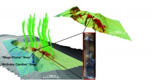
When scientists look for oil, they start by looking for marine seeps, areas where oily fluids and gases ooze from the seafloor, often extending plumes of hydrocarbon-rich gas bubbles high into the water column. Then they drill in the area of the seep to explore for oil.
“There isn’t oil everywhere,” said Garrett Mitchell, a geoscientist at Fugro Marine GeoServices and lead researcher on the project. “We are telling them where to look and reducing their need to drill in many places.”
The new study began with a routine survey exploring the deep sea. Realizing the brand new multi-beam sonar used to map the seafloor was not calibrated right, Mitchell and his team looked into software programs and data gathering techniques to enhance the results.
Just like dolphins use echolocation to locate and identify objects, sonar uses sound to explore the seafloor. A ping is emitted from a ship’s sonar. The echo of that sound energy bouncing off the seafloor provides information on depth and bottom material like rock or mud. Scientists can tune the sonar to also focus on the midwater region, which could show the plumes of an active seep.
“We explore the seafloor with sound, and when it interacts with the seafloor it will give us information,” Mitchell said.
The sonar takes a snapshot of a small area in the deep ocean, but problems interpreting the signal arise because hard materials will reflect sound differently than soft materials, according to Mitchell. Additionally, the location directly below the vessel, called nadir, is one known problem area for sonar. High quality maps are crucial for finding seeps, but software that processes the data varies, often producing slightly different seafloor images.
Mitchell and his team tested a new combination of software and data collection techniques as a solution. They set sail for a previously explored site in the Northern Gulf of Mexico where they tested both the sonar settings and three software packages before heading into unexplored waters. They scanned the seafloor at different angles and used an average of the pixel data to fill in the nadir data gap. They then compared the results to the very high resolution datasets previously collected. The team tested several iterations before finally landing on a software package and data collection technique that created more refined maps of the seafloor.
They found their method also detected the giant plumes characteristic of marine seeps. Scientists could use the new method to better locate seeps in the deep ocean rather than using more invasive methods, reducing the effects of oil exploration on marine life, according to the researchers.
“It is worth it to the oil industry because it is helping us find locations where good oil is seeping through,” Mitchell said.
—Teresa L. Carey is a graduate student in the Science Communication program at UC Santa Cruz. Follow her on Twitter at @teresa_carey.


 GeoSpace is a blog on Earth and space science, managed by AGU’s Public Information staff. The blog features posts by AGU writers and guest contributors on all sorts of relevant science topics, but with a focus on new research and geo and space sciences-related stories that are currently in the news.