15 December 2016
Deposits discovered in Monterey Canyon’s mouth may cause marine landslides, study finds
Posted by dgaristo
By Sukee Bennett
Researchers have discovered a large concentration of sediment deposits at the end of Monterey Canyon, an underwater chasm beneath Monterey Bay, California. The sediment
deposits are relatively young and may be more likely to catalyze underwater landslides than other sections of the canyon, according to the researchers who presented their discovery at the 2016 American Geophysical Union Fall Meeting.
Like shifting tectonic plates, marine landslides—which cause sediments to tumble below the surf and displace water in their wake—are powerful enough to generate large waves or even tsunamis. If this were to happen in the Monterey Bay, an area spanning approximately 80 kilometers (50 miles) from Santa Cruz to Pacific Grove, tens of thousands of people and countless marine animals could be affected.
Scientists have been studying Monterey Bay’s dynamic seafloor for more than half a century. Previous research suggests the underwater landscape has shifted, segmented and grown for millions of years, and the new study unveils more of the canyon’s intricacies.
“This is a very dynamic, complex and interesting area around the head of the canyon,” said Katherine Maier, a research geologist with the United States Geological Survey in Santa Cruz, California and the lead author of the new study.
The bottom of Monterey Canyon sits more than two miles below the surface of the sea, making it akin to an underwater Grand Canyon. But unlike its landlocked cousin, Monterey Canyon is a place where land and sea converge. Its evolution and that of the surrounding region is dependent on both onshore and offshore processes—the flow of rivers, the deposition of sediments and, scientists suspect, the movements of waves.
But the exact history of the canyon’s development over time is not clearly understood.

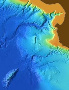
A 3-D map of Monterey Canyon. Researchers have just discovered a large concentration of sediment deposits at the end of the Canyon that may be more likely to catalyze underwater landslides than other sections of the canyon.
Credit: NOAA Photo Library/Flickr.
To find out more about its evolution, USGS scientists explored Monterey Canyon in 2015 using a device called a multi-channel streamer that generates high-resolution seismic imagery. From the imagery, they generated maps of the canyon’s stratified cliffs and channels as part of the California Seafloor Mapping Program, which is working toward mapping out all of California’s state waters and generating publicly accessible data.
Previous research lacked the technology needed to unearth the complexities of the seafloor, but Maier and her team’s access to high-resolution imagery allowed them to stumble upon the sediment deposits near the head of the canyon—the area closest to shore—that were previously overlooked. Using even higher resolution imagery, they analyzed different angles and sections of the canyon, generating pictures of distinct layers of sediment that accumulated over time.
The researchers suspect that the canyon’s sediment deposits formed less than 2.6 million years ago and that the canyon head is possibly only 21,000 years old. On geological timescales, it’s an infant—much younger than the wider sections of canyon farther offshore, Maier said.
“The seafloor we see isn’t necessarily all the same age,” she said.
The youthful section of the canyon directly offshore is less solid and less compacted into solid rock as the canyon’s more ancient depths, meaning it’s relatively unstable and more prone to marine landslides, Maier said. When a large amount of sediment moves, it displaces the water around it. And if the slide is large enough, a large wave or even a tsunami can occur, she added.
Maier and her team are still unsure if landslides along the Monterey Canyon could ever be substantial enough to generate a giant wave, however. While the current study does not address tsunamis directly, the research team plans to investigate this further in the future.
“It’s practically our backyard,” Maier said of the Monterey Canyon. “But we’re still learning new things.”
—Sukee Bennett is a science communication graduate student at the University of California Santa Cruz. Follow her on Twitter at @Sukee_B.


 GeoSpace is a blog on Earth and space science, managed by AGU’s Public Information staff. The blog features posts by AGU writers and guest contributors on all sorts of relevant science topics, but with a focus on new research and geo and space sciences-related stories that are currently in the news.