25 October 2016
Stone walls, railway lines and carbon fibers record Turkey’s westward drift
Posted by Lauren Lipuma
By Laura Krantz

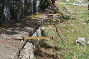
This wall does not have ears, but for 47 years it faithfully recorded the silent slip between the Asian and Turkey plates.
Credit: Roger Bilham.
In February 1944, a magnitude 7.4 earthquake shook a sparsely populated region of central Anatolia in Turkey. Within hours, the steel rails of the Ankara-Istanbul railroad began to distort. By the next day, they had been misaligned by roughly four meters (more than 13 feet) as a result of slip on the North Anatolian Fault, a fault with many similarities to the San Andreas Fault in California. But despite decades of observation, the history of the fault and its movements haven’t added up. Now a new study sets that history straight and shows how the incremental activity along this fault may provide insight into future, larger seismic events. The study was published in the Journal of Geophysical Research: Solid Earth, a journal of the American Geophysical Union.
“Everyone knew this fault was creeping but no one knew how,” said CIRES scientist Roger Bilham. Two years of close observation showed that movement on the fault tends to happen episodically—meaning the fault stays quiet for long periods of time before making smaller, and then larger, sudden slips. Those sudden slip take a few hours but release about the same energy as a magnitude 5 earthquake. “It is so slow,” said Bilham, “That you would be unaware of the slip were you sitting on the fault eating a sandwich.”
Back in 1944, the Turkish railway engineers who spent a week fixing the railroad had no idea the tracks had been built across the boundary between the mighty Eurasian tectonic plate and the Turkey tectonic plate which, at this point, heads relentlessly westward by about two centimeters (roughly ¾ inch) per year. The North Anatolian Fault, like the San Andreas fault, slips both during earthquakes and also silently between them by a process known as “creep”.
For the next six years the North Anatolian fault continued to slip without earthquakes. Train engineers had to slow to walking speed in this area because passengers would otherwise be thrown into each other as the train crossed the fault. By 1950 the jog in the line offset the tracks by two feet, eventually forcing railway engineers to fix it again.
In 1957, a stone wall was inadvertently constructed across the fault, its northern half on the EuroAsian plate and its southern half on the Turkey Plate. In 1969, a party of geologists showed up in Turkey, searching for evidence of slip in the 1944 earthquake. “They were astonished,” said Bilham, “To see that the wall where it crossed the fault had been offset by roughly 10 centimeters (four inches)—a wall that had clearly been constructed 13 years after the 1944 earthquake.” The geologists realized the fault was still creeping and calculated its rate of slip as about 1.2 centimeters (½ inch) per year. Close to 50 years later, as Bilham and Mencin began their research in this area, the wall remains, but now it’s offset by almost 45 centimeters (18 inches) due to a silent fault slip at an average rate of nearly one centimeter (⅓ inch) per year since 1969.
To get a better sense of how the fault was moving, they installed a carbon fiber rod in a PVC tube slantwise across the fault. The carbon rod is anchored on one side of the fault and a transducer at the other measures the displacement of the free end of the rod to a precision of one-tenth the thickness of a human hair. They found that the fault remains stuck for many months, and then slips at a hair’s-breadth each day for a few months, and then experiences a sudden (but silent) jump of up to half an inch.
Calculations show that slip on the fault during these silent earthquakes (which happen every 8-14 months) extend to a depth of 3.2 – 6.4 kilometers (2-3 miles) beneath the Earth’s surface. They also show that the surface fault will slip nearly another meter (three feet) before the next big earthquake on the fault. One distinct possibility is that a future silent earthquake will be the straw that breaks the proverbial camel’s back. That is, one of these silent slip episodes may set off a future magnitude 7.4 earthquake in central Anatolia. With that in mind, the monitoring of the creep process may provide a clue about the imminence of another major earthquake. “This should make no one anxious,” said Bilham. “Calculations—and history—show that the fault should not slip in a magnitude 7.4 earthquake for another 150 years.”
– Laura Krantz is a science writer at CIRES. This post originally appeared on the CIRES website.


 GeoSpace is a blog on Earth and space science, managed by AGU’s Public Information staff. The blog features posts by AGU writers and guest contributors on all sorts of relevant science topics, but with a focus on new research and geo and space sciences-related stories that are currently in the news.
Some other photos along the Gerede segment of the North Anatolian Fault here, including one of the site you feature in the photo, prior to instrumentation: https://blogs.agu.org/mountainbeltway/2010/12/06/gerede/