
13 December 2013
NEPTUNE and VENUS: Sentinel sea observatories of the north Pacific
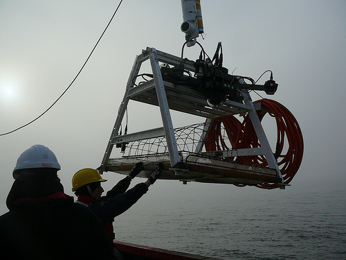
VENUS observatory experiment is lowered into the Strait of Georgia. Credit: Ocean Networks Canada
Wally the robot crawls along the ocean floor, watching the bubbles. And 8,000 miles away, a German scientist sits on a couch with a laptop, watching with him.
Wally the Crawler collects data for NEPTUNE, a group of six seafloor observatories linked by an 800-kilometer telecommunications cable off the coast of Vancouver, Canada. Started in 2009 by Ocean Networks Canada, NEPTUNE is a versatile research enterprise, with its various nodes able to conduct biological, oceanographic, geophysical, and seismological studies.
With stations interspersed at depths ranging from 23 to 2,660 meters, the network tracks the myriad phenomena occurring along the continental shelf and the deep sea. Each observatory sends real-time updates to scientists across the globe, and some sites have live feeds for the public.
Wally, for instance, lives in Barkley Canyon, where a mishmash of creatures has adapted to cope with the tremendous pressure created by 985 meters of ocean sitting on top of them. Wally offers an around-the-clock window into the lives of spider crabs, thornyhead fish, and other oddball fauna living in the basin.
This seafloor drone also monitors the bubbles created by gas hydrates—natural gas molecules trapped in cages of water molecules. Typically made of methane, gas hydrates form mounds in the sediment that fluctuate in size with changes in temperature.
Gas hydrates could serve as a harbinger for climate change, according to geophysicist Martin Scherwath of Ocean Networks Canada.
“Methane is estimated to be 20 times more potent than carbon dioxide as a climate gas,” Scherwath said Wednesday at the American Geophysical Union’s Fall Meeting in San Francisco. “Our observatories are equipped with temperature, salinity, pressure, and oxygen sensors built to last 25 years and to detect subtle changes in the environment.”
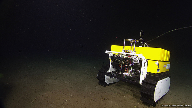
Wally the Crawler voyages across Barkley Canyon. Credit: Ocean Networks Canada
Take for example a surprise discovery made by the network on March 11, 2011, the day of the Tōhoku earthquake in Japan
More than 5,000 kilometers from the epicenter, the waves broke softly over the deep-sea Endeavour observatory. The movement was almost imperceptible to the human eye, but it was detected by Endeavour’s pressure recorders, located over a hydrothermal vent on the Juan de Fuca Ridge, approximately 200 kilometers west of Vancouver.
“In the deep ocean, the height of the tsunami is centimeters, so you wouldn’t really see them from a ship because the ocean swell is on the order of meters,” Scherwath said. “But because these are long period wavelengths, outside the frequency range of normal swells, you can see them quite nicely with our probe.”
The researchers are now building models to predict where the greatest damage will occur when the next tsunami strikes the North Pacific.
Tsunami Sans Quake
Ocean Networks Canada runs another cabled network in the Salish Sea and the Strait of Georgia, which separates Vancouver from its barrier islands.
Dubbed VENUS, the three observatories measure sediments collecting near the mouth of Vancouver’s Fraser River. These sediments pose an unsuspecting threat to the island communities, including the British Columbia capital of Victoria.
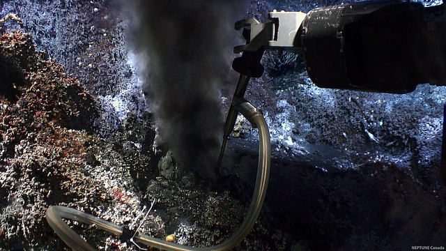
The Endeavour, located 2,000 meters below sea level, makes a recording from a black smoker hydrothermal vent. Researchers at NOAA receive live temperature readings from the site and, when aberrations occur, they can collect biological samples by clicking a button. Credit: Ocean Networks Canada
“As the sedimentation piles on the river delta, it can become relatively unstable and gets easily overloaded, causing regular landslides,” Scherwath said. “If you have a big enough slide plane, it can actually generate a local tsunami.”
Such an event would hit the nearest islands within a few minutes with a wave up to nine meters high.
VENUS uses sonar to build acoustic profiles that estimate the stability of the muddy shelf deposits. Scientists are scanning these profiles of small slides for pressure signatures that may indicate an upcoming power slide.
“We know there is a threat, and we want to know exactly what is happening there,” Scherwath said.
– Nsikan Akpan is a science communication graduate student at UC Santa Cruz


