19 August 2015
New study shows significant tsunami strength for parts of Southern California
Posted by larryohanlon
By Larry O’Hanlon

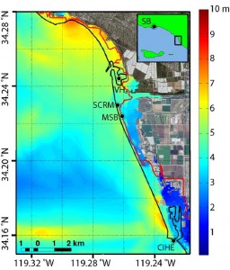
This map shows the simulated peak tsunami amplitude around Ventura, CA, resulting from slip on the Pitas Point and Lower Red Mountain fault system. The solid black line indicates the coastline. The solid red line is the statewide tsunami inundation map coordinated by the California Emergency Management Agency. The inundation from the model is significantly greater in many places than the statewide estimate.
Credit: K.J. Ryan, et al.
A new simulation of tsunamis generated by earthquake faults off the Santa Barbara coast demonstrates a greater potential for tsunami inundation in the cites of Ventura and Oxnard than previously thought.
The simulation looks at ruptures on the subterraneously connected Pitas Point and Lower Red Mountain faults. These 45 and 35 kilometer (31 and 22 mile) long faults, less than 150 meters (500 feet) underwater, are capable of producing tsunamis that would hit the nearby coast.
Low-lying homes and buildings on the coastline directly opposite these faults would naturally be vulnerable to the tsunami. But farther to the east are additional low-lying areas that were not necessarily expected to be in harm’s way if a tsunami were to hit — until now.
“The tsunami rotates and refracts – turns and focuses on the Ventura-Oxnard area,” said Kenny Ryan of the University of California at Riverside and lead author of a new study detailing the simulation. “That’s a really interesting result that we didn’t expect.”
When Ryan and his colleagues compared the inundation areas from their simulated tsunami to those of the State of California, they found that the tsunami would penetrate twice as far inland at some locations than the State’s official tsunami inundation line. The simulation predicted tsunamis which could flood up to 2 kilometers (1.2 miles) inland, according to the new study in Geophysical Research Letters, a journal of the American Geophysical Union.
“Locally this would be very problematic for the area,” said Ryan of the potential tsunami effects on Ventura and Oxnard.
The study’s authors used one interpretation of the latest seismic data about the structure of the two faults, as well as evidence of past ruptures of related faults on land to determine how a rupture might occur on the undersea faults. They then modeled how the resulting changes to the ocean floor would generate a tsunami and how those waves would affect the coastline.
The new study shows that a tsunami generated by an earthquake on the Pitas Point and Lower Red Mountain faults splits in two: one wave moves north toward Santa Barbara and the other moves south toward Santa Cruz Island. As the southern wave hits deeper water it changes direction and heads toward Ventura and Oxnard. The resulting tsunami at Ventura and Oxnard would be up to 7 meters (23 feet) in height and penetrate up to 2 kilometers (1.2 miles) inland.
For all its effects, the tsunami would primarily be only a local hazard, as opposed to the sort of transoceanic tsunami that are caused by extremely large earthquakes in subduction zones – those places where one tectonic plate is being pulled and pushed beneath another – like those south of Sumatra and east of Japan. Unlike transoceanic tsunamis, local tsunamis don’t affect large areas, but because they occur close to the shore, residents usually only have minutes to prepare, he added.
A local tsunami like the one described in the new study may have occurred following the 1812 Santa Barbara earthquake. The 7.0-magnitude event was likely caused by an offshore fault, which damaged Mission San Buenaventura in Ventura and triggered a tsunami throughout the region. News reports from the time described it as a “huge” sea wave.
The new simulation is just one scenario for what could happen if an earthquake were to occur in the Santa Barbara Channel, Ryan said. But it’s not the only possibility. The Earth’s crust off Santa Barbara and Ventura counties is riddled with faults that are caught in what some geologists describe as a “tectonic train wreck” between the Pacific Plate and the North American Plate. Earthquakes on faults in this high-pressure tectonic zone can shove the seafloor upwards, pushing the water up and creating tsunamis that would affect local coastlines. They could also trigger undersea landslides, which would also launch local tsunamis, Ryan explained.
With further development and the addition of several more models, this means California may have to update its tsunami plan for the area, said Ryan. It might even be good to do an in-depth hazard and risk analysis similar to the U.S. Geological Survey’s 2013 Science Application for Risk Reduction (SAFRR) scientific report, which studied a hypothetical tsunami created by a magnitude 9.1 earthquake offshore of the Alaskan peninsula.
“There are a lot of houses and structures in that area (of Oxnard and Ventura),” said Ryan. “We probably would need something like SAFRR to produce a more accurate evaluation of the area.”
– Freelance science journalist Larry O’Hanlon acts as AGU’s blogs manager and social media coordinator.


 GeoSpace is a blog on Earth and space science, managed by AGU’s Public Information staff. The blog features posts by AGU writers and guest contributors on all sorts of relevant science topics, but with a focus on new research and geo and space sciences-related stories that are currently in the news.