
7 December 2011
Volcanic bridges across the abyss
Posted by kramsayer
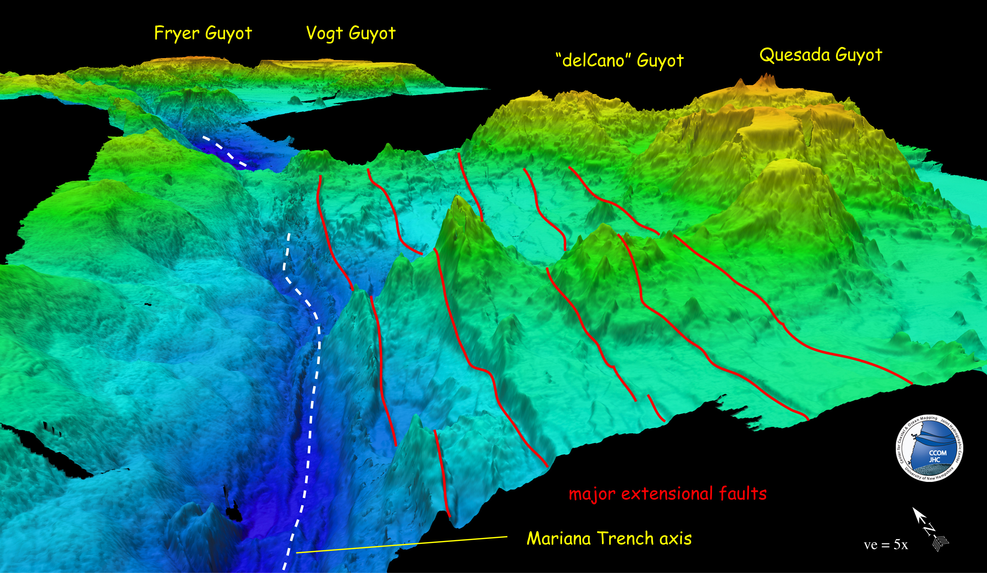
Looking north along the Mariana Trench axis where several “guyots,” or undersea volcanoes, have formed a bridge to the opposite trench wall. (Credit: Center for Coastal Ocean Mapping Joint Hydrographic Center)
Marine geologist Jim Gardner’s job allows him to command large ships, map underwater bridges, and travel the world’s oceans. And he does it all in the name of the Law — The United Nations Commission on the Law of the Sea, that is.
Gardner is tasked with mapping large patches of the seafloor for the U.S. through the Center for Coastal Ocean Mapping Joint Hydrographic Center at the University of New Hampshire.
A 200 nautical mile zone surrounds the United States, starting from three miles off U.S. shores, called the Exclusive Economic Zone (EEZ). Within the EEZ everything between the ocean surface and below the seafloor falls under U.S. jurisdiction – including fisheries or seafloor minerals. Proving that the continental shelf naturally extends past 200 nautical miles would allow the United States control of what is found on the seafloor and beneath it.
Gardner presented his results from mapping a possible natural extension of the EEZ – an underwater “bridge” – during Monday afternoon’s poster session at the American Geophysical Union’s Fall Meeting.
The bridge is across the Mariana Trench, near Guam and the Marianas Islands – both U.S. territories. There, as one plate subducts under another, underwater volcanoes on one side have smashed into the opposite trench wall as they arc into their descent, forming bridges. Gardner has mapped four “bridges” 2,500 m above the trench’s axis, which could act as an EEZ extension from the Pacific island US territories Pacific plate extension.
With the ship at his beck and call, Gardner’s search for additional bridges zigzagged him across the trench multiple times – so he decided to map its entire length for the first time at this resolution. Using the latest state-of-the-art sonar to produce the underwater topographic maps, he measured the time it took for the sonar’s multiple low frequency sound pulses to bounce off the bottom and return to the ship. Gardner went to “wild extremes,” he says, to continuously correct for the speed of sound and fed calculations (50 times a second) from the boat’s motion and alignment to produce accurate seafloor maps. If a significant glitch in the data appeared, he halted the ship and started over.
Surveys took him over the deepest point on the seafloor which the Russians measured in the late 1950s at 11,034 m. As an afterthought, Gardner analyzed his multiple soundings to measure the deepest point and arrived at a precise – albeit shallower – depth of 10,994 m.
Gardner’s penchant for charting the seafloor has also included the Line Islands, Necker Ridge off Hawaii, the entire east coast of the United States, the Gulf of Mexico, and the Gulf of Alaska.
The only place he doesn’t work is the Arctic Ocean. “My rule of thumb is that I don’t work at a latitude higher than I live,” he says.
-Amy West is a science communication graduate student at UC Santa Cruz


[…] senaste djupmätningen är nyligen avslutad och fastställer djupet till 10 994 meter, med en osäkerhet om 40 meter. Det är mer än 2 kilometer djupare än […]