14 December 2010
New eyes on the ocean
Posted by mohi
A global flotilla of diving robots have their eyes trained on the seas. An ocean monitoring program, called Argo, run by the National Oceanic and Atmospheric Association, has currently deployed 3,239 satellite-connected floats. These monitors are constantly diving, free floating and surfacing. They are the marine equivalent to weather stations on land, recording temperature, salinity, dissolved oxygen, and chlorophyll levels. Information is then beamed in real-time to data centers in France and California. And a new breed of floats is about to do more.
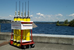
Charles Eriksen, a physical oceanographer at the University of Washington, announced in Monday’s session “The Autonomous Revolution: Transforming Ocean Observation with Mobile Platforms” (OS13H) that these new instruments–deep gliders that will be capable of reaching the full depths of the ocean–will soon be ready to take to the waters.
One of the new deep gliders was deployed off the coast of Puerto Rico last week, exploring a spectacularly deep region of the ocean floor known as the Puerto Rican trench.
The current sea gliders operated by Argos can dive to roughly 2000 meters, before the pressure becomes too much for them. This leaves the bottom two thirds of the ocean unexplored. After eight years of development, the deep gliders, which can reach depths of 6000 meters, are only a month or two away from deployment, Eriksen estimates.
The ocean, the whole of it, is important to monitor because recurrent ocean cycles affect our planet’s weather. Scientists also expect that the planet’s weather, as the Earth warms, will alter ocean currents. Argo data gives us an up-to-date view of the state of the oceans. The new instruments will help scientists to fully see the changes in the ocean’s currents as they occur at depths previously unmonitored.
Part of the value of this array of monitors, aside from their constant stream of data, is that they are very cost effective. A ship-based expedition costs at least $30,000 a day. For the same amount of money, an Argos float can provide a year of data. For modern oceanographers, monitoring satellite transmitted data on an office computer may not be quite as fun as feeling gusts of salty air on their faces, but trading ship time for desk work may be the shape of the future.
–Danielle Venton is a science communication graduate student at UC Santa Cruz


 GeoSpace is a blog on Earth and space science, managed by AGU’s Public Information staff. The blog features posts by AGU writers and guest contributors on all sorts of relevant science topics, but with a focus on new research and geo and space sciences-related stories that are currently in the news.