27 February 2019
Old stone walls record history of Earth’s magnetic wanderings
Posted by llester
By Liza Lester
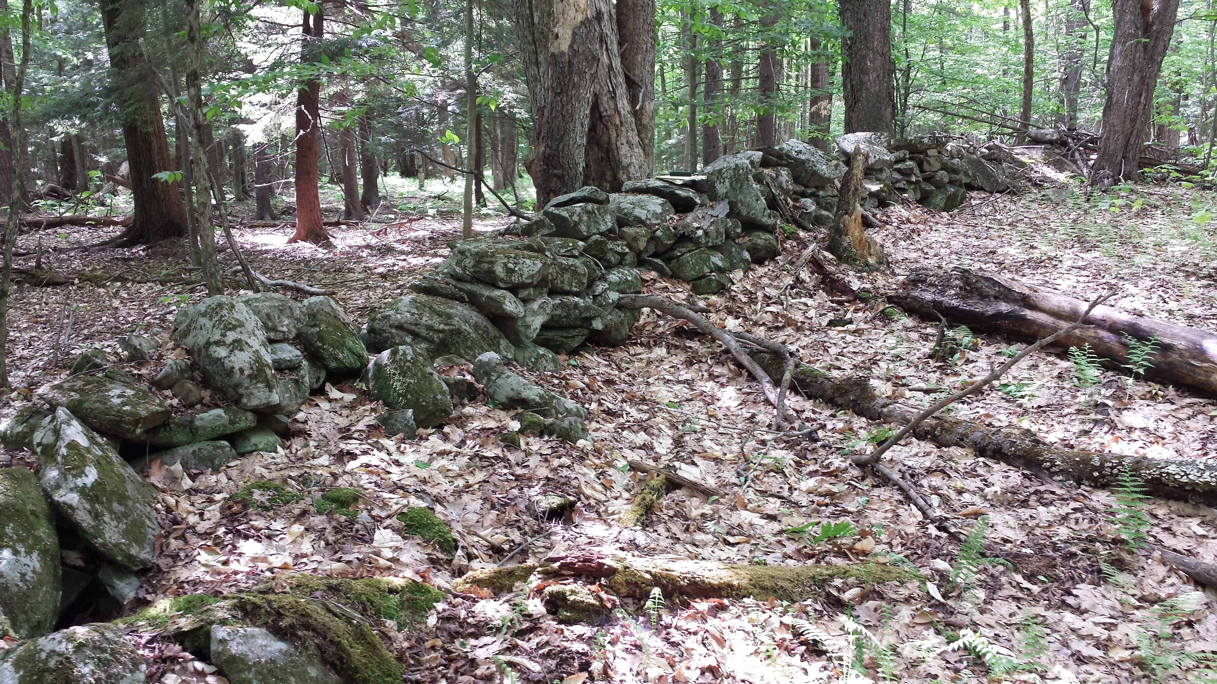
An old stone wall marks a boundary of a long-abandoned farm near Grafton, New York, once part of the colonial Manor of Rensselaerwyck. A section of the 700,000-acre manor west of the Hudson River was was surveyed for rental allotments in 1787.
Credit: John Delano
Under the forests of New York and New England, a hidden tracery of tumbledown stone walls marks the boundaries of early American farms, long abandoned for city jobs and less stony pastures in the West.
These monuments of an agrarian past also mark past locations of Earth’s itinerant magnetic north pole, a record leveraged by geochemist and local history buff John Delano to reconstruct a history of our planet’s magnetic field in eastern North America in a new study published in AGU’s Journal of Geophysical Research: Solid Earth.
“As a little kid growing up in the country in New Hampshire, I was fascinated with stone walls that were in the middle of the woods. Who made them? Why?” said Delano, an emeritus professor at the State University of New York at Albany. “Post-retirement, I had the time to pick that study up and wondered, now with a different skill set: What do they remember? What are they telling us?”
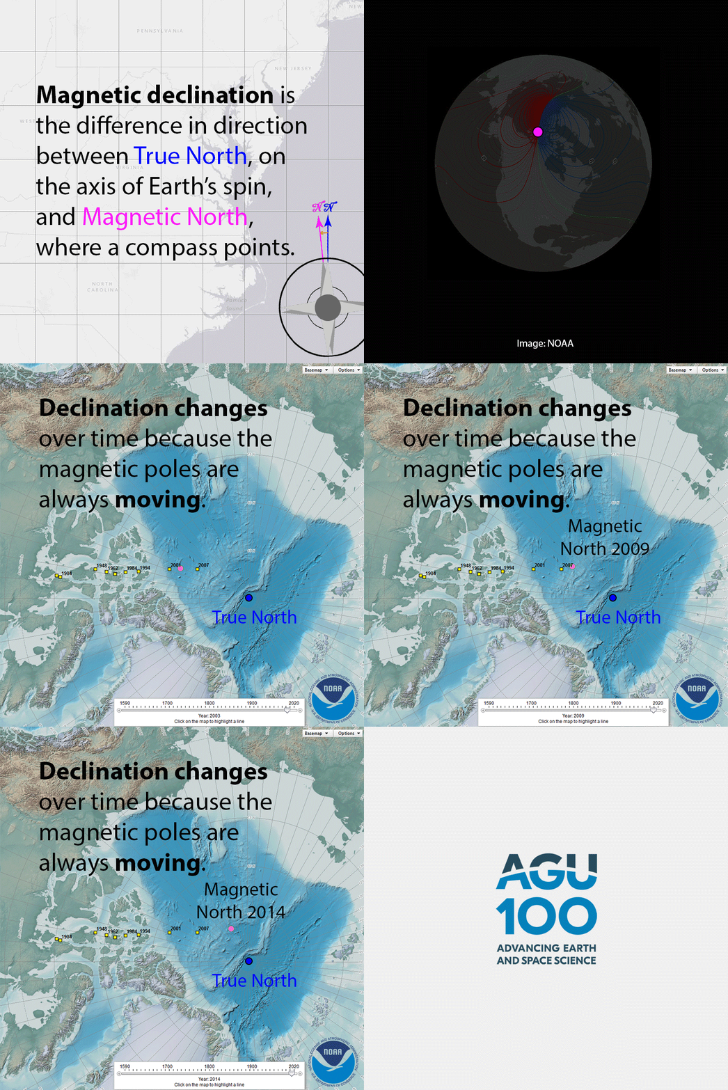 On a visit to his local historical society, Delano had a eureka moment while looking at map from 1790. From the jumble of stone walls on his present-day map, a grid pattern emerged that looked much like the property boundaries of the many 100-acre farms in the late 18th century township.
Delano got his hands on hundreds of original, 18th and 19th century surveys from the New York State archives and overlaid modern aerial images of the stone walls to find the walls that marked the old property boundaries. Using GPS, he measured the walls’ present-day bearings with respect to True North and compared them to compass bearings for the boundary lines, recorded by the 18th and 19th century surveyors.
The discrepancy between Delano’s measurements and the historical compass readings is not the error of the early surveyors, but the magnetic declination at the time of the survey. The difference between True North and magnetic north shifts over time due to changes in Earth’s outer core.
Modeling the wanderings of Earth’s magnetic field can provide clues to the enigmatic motions deep in the Earth that generate it.
“Some geophysicists who are trying to model these complex motions of fluids are helped in their analysis by having a very accurate record of how the declination has moved over time,” Delano said.
Wayward poles
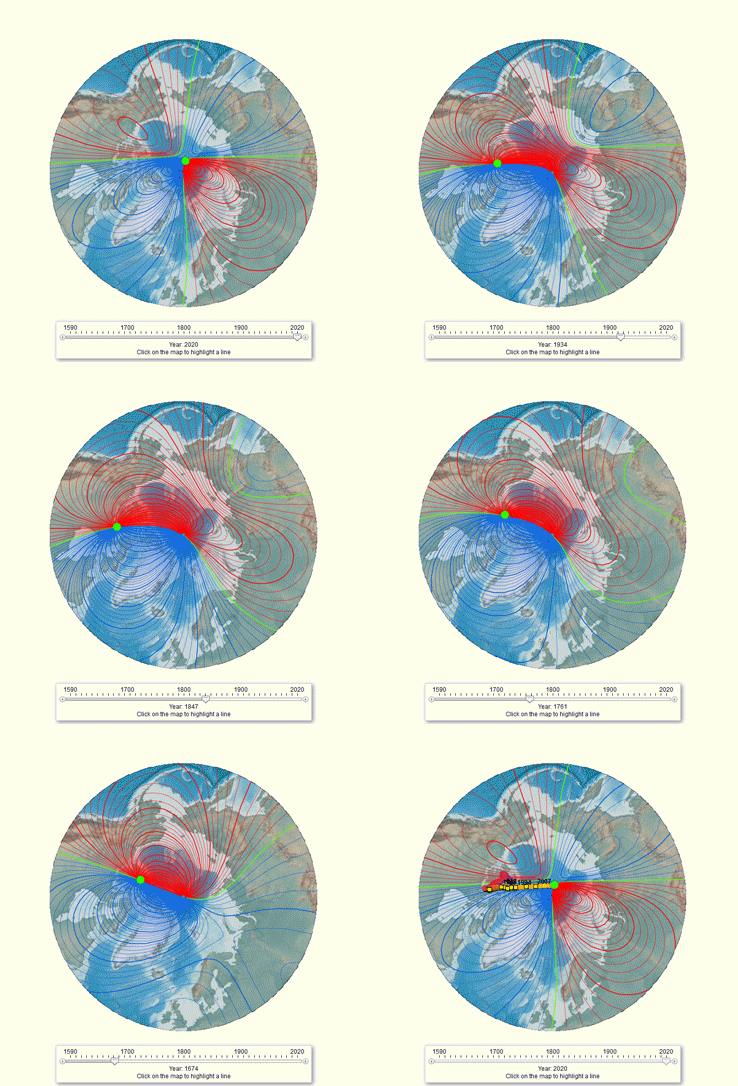
Historical magnetic declination 1590-2020.
Credit: NOAA National Centers for Environmental Information
Geologists and navigators have long known that the north pole found by magnetic compass is not the same as True North, the point at 90 degrees N latitude that sits on the axis of Earth’s spin. The angle of deviation is called magnetic declination, and its degree varies depending on where the compass holder stands on the globe.
This difference matters not just for bushwhackers making their way without a GPS device, but for military and commercial aircraft, ships, submarines and even smartphones, which still use Earth’s magnetic field for orienteering.
Declination information must be updated frequently, because, unlike True North and South, Earth’s magnetic north and south poles are not fixed points. They move by tens of meters (yards) every day at erratic rates and directions. Motions in the fluid, molten metals that surround Earth’s core are believed to generate the magnetic field, although the deep layers of the planet cannot be observed directly. The dynamics of the system are not well understood.
Scientists can only model future positions of the magnetic north and south poles a few years into the future. The magnetic north pole has moved so quickly in the last few years, at 50 kilometers (30 miles) per year, the U.S. National Geophysical Data Center and the British Geological Survey released an early update to the joint World Magnetic Model’s 5-year cycle earlier this month.
Finding north with old stone walls
 Historical data on the movements of the magnetic north pole provide clues to the behavior of Earth’s dynamo. Previous research groups have modeled magnetic declination from 1590 to today, based primarily on extensive sailing ships’ log records of magnetic north and the position of the North Star.
“That’s magnificent work, enormously tedious, with great detail and commitment on their part to do it, but they had little land-based data. And that’s where my work came in,” Delano said. “Using land-based methods, an entirely different approach, how would it match up, or not, with the current geophysical model?”
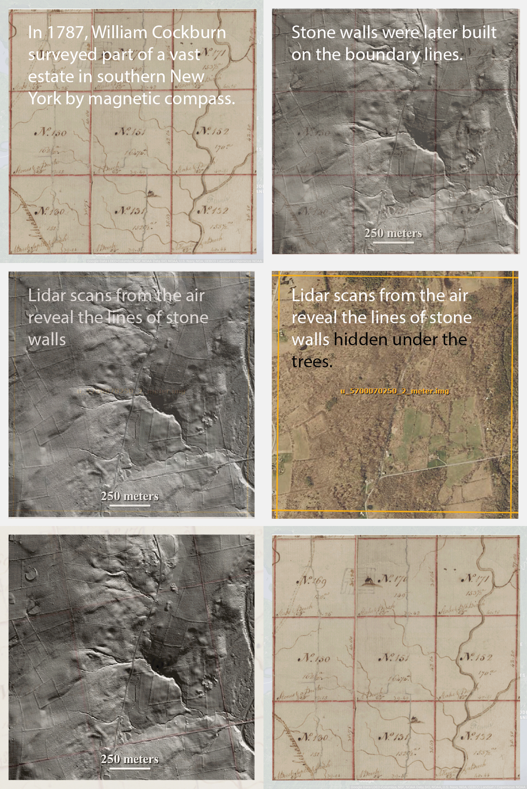
Walking the walls to map them with a hand-held GPS unit proved too time consuming for systematic measurements—Delano spent more than 200 hours in the woods mapping stone walls in a single square mile—so he learned a new technology in his retirement. Although a new forest has long since grown up over the abandoned fields, the old walls are easily visible to the penetrating laser gaze of aerial based “light radar” or lidar. Public lidar scans revealed 1,200 kilometers (750 miles) of boundaries surveyed in 1685-1910 and marked by remnant stone walls.
The glaciers of the most recent ice age left plentiful rock in the soil of New York and New England to trouble farmers. Old world colonists and their descendants moved the stones to the field edges, which often lay on surveyed property boundaries. The rock piles were later built into walls. The wall persisted long after the farms were forgotten, allowing Delano to orient the survey maps of centuries past on the present day landscape and recreate the surveyors’ compass measurements.
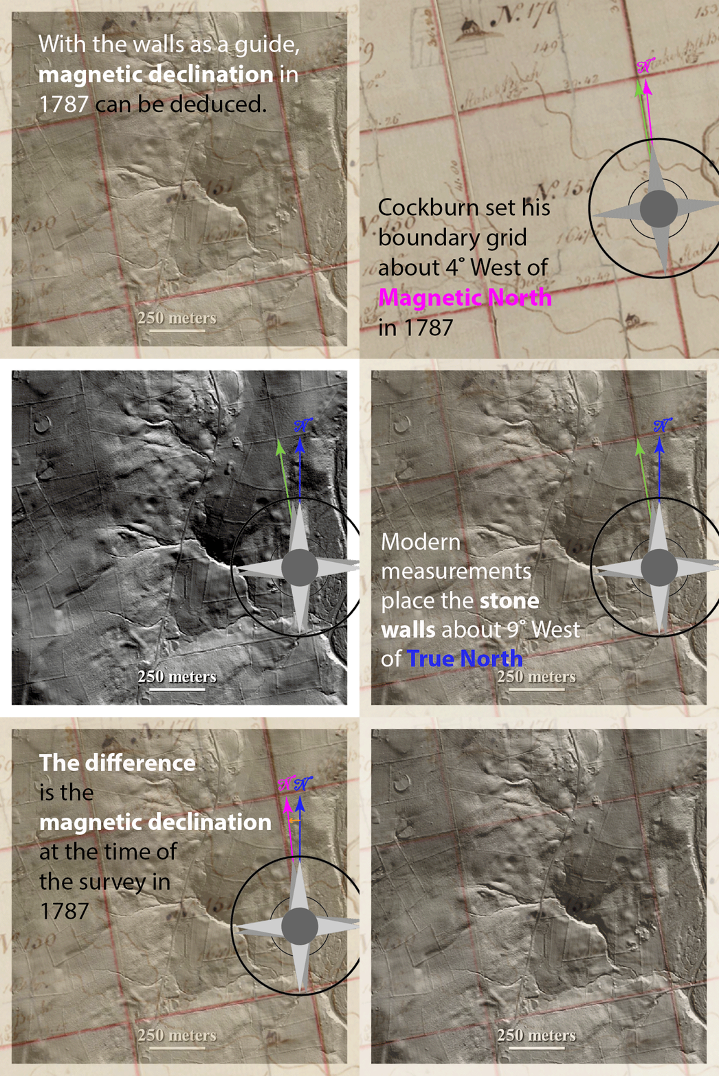 Delano calculated historical declinations for 22 regions in New York and New England by matching old stone walls to original survey maps.
He also used Google Earth Pro to take the bearing of Boundary Street and the original main street in Colonial Williamburg, Virginia, for comparison with compass bearings recorded in 1699.
The results of the new study fit well with historical magnetic declination models with the exception of a 35-year span from about 1775 to 1810, when the evidence of the stone walls places magnetic declinations up to 1.5 degrees east of the existing model values. Magnetic declinations in 1750-1780 were up to 2.0 degrees westward of U.S. Historic Magnetic Declination Estimated values.
“The stone wall study, with only a small difference during a small interval of time, matched up beautifully with the existing geophysical model,” Delano said.
The approach has the potential to be used in Europe, Southeast Asia, and other parts of the world that have old roads, walls and deep records, according to Delano.
“Whatever sample, whatever thing I’m studying, I ask myself, what memory does it contain?” Delano said. “There are stories in the walls.”


 GeoSpace is a blog on Earth and space science, managed by AGU’s Public Information staff. The blog features posts by AGU writers and guest contributors on all sorts of relevant science topics, but with a focus on new research and geo and space sciences-related stories that are currently in the news.
“Motions in the fluid, molten metals that surround Earth’s core are believed to generate the magnetic field, although the deep layers of the planet cannot be observed directly. The dynamics of the system are not well understood.”
Thanks for an honest and clear statement that most of what we “believe” to be the cause is hypothesis. This is too often presented as though it was “settled science” rather than educated guesses.
Fascinating article! Having lived in NY and spent much time roaming the lands of New England, I’ve seen many of those stone walls out where it seemed like nowhere and wondered what they were saying of former times. Of late, I’ve taken an interest in compass navigation. This article has helped me understand the wondering of magnetic north. Now seeing that the internal forces that have always been active within our planet and likewise, climate change has always existed on our planet, are their products related?….