4 January 2017
Snowflake variability has significant impact on remote sensing of snowfall rates
Posted by Lauren Lipuma

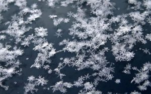
Every snowflake is unique—and that could have a big effect on determining how much snow will fall, according to new research.
Credit: Kevin C Chen (Own work,) CC BY-SA 2.0, via Wikimedia Commons.
By Dan Garisto
Editor’s Note: This post was updated on 5 January 2017. A draft version of this post was erroneously posted on 4 January 2017.
Every snowflake is unique—and that could have a big effect on determining how much snow is falling using remote sensing measurements, according to new research.
Meteorologists measure snowfall rate by sending out radar signals, which bounce off falling snowflakes. By measuring the amount of radar reflectivity, or how much of the radar signal bounces off the snowflakes, scientists can determine the snowfall rate.
The radar reflectivity is affected by different snowflake properties, such as the mass of the snowflakes. Most meteorological models of snowfall factor in the variability of snowflake mass but few include other variabilities, like the variability in aspect ratio, or the ratio between the width and height of the snowflake, and the variability in orientation, or the angle at which the snowflake is oriented relative to the radar and the horizon.
A new study finds that accounting for variability in these properties can lead to differences in derived snowfall rates of more than 50 percent.
“If you had no variability at all, you would assume that every snowflake has the same size, shape, and orientation,” said Mathias Gergely, an atmospheric scientist at the University of Utah in Salt Lake City, and lead author of the new study published in the Journal of Geophysical Research: Atmospheres, a journal of the American Geophysical Union. “You would basically assume that any one snowflake would be representative of all snowflakes in the snowstorm … but as everybody says and knows, every snowflake is unique.”
The new study is one of the first to quantify the impact of variability of aspect ratio and orientation on snowfall rate, according to Gergely. Even snowflakes within the same snowstorm can be dramatically different from each other, so it’s important for researchers to consider their variability both among different snowstorms and within individual snowstorms when analyzing snowfall remote sensing measurements, he said. Snowfall rate governs how much snow accumulates on the ground, so an accurate snowfall rate is important for everything from avalanche mitigation to water resource management, he said.
The authors of the new study used an extensive set of high-resolution snowflake images captured for several snowstorms to get a better look at individual snowflakes. Gergely and his co-author, Timothy Garrett, then used these images to determine how much snowflakes varied in three properties: diameter, aspect ratio and orientation. They then calculated how much radar reflectivity would be affected by the observed variability in these properties.
The new study found variability in snowflake diameter has the largest impact on radar reflectivity, but aspect ratio and orientation are also key: failing to account for a realistic quantification of variability in these two properties could alter radar reflectivity by more than 60 percent. This change could affect measurements of snowfall rates by more than 50 percent, according to the new study.
Modeling that includes a realistic representation of variability of snowflake aspect ratio and orientation could greatly improve radar measurements of snowfall rate compared to merely including the variability of snowflake mass or size, according to Gergely.
“If your question is ‘Does it snow?’ then it is not crucial to include a detailed description of snowflake aspect ratio and orientation in the analysis of snowfall radar observations,” he said. “But if you really want to derive a quantitative snowfall rate [that’s] a reliable estimate of the real snowfall rate, you need to account for the natural variability in these properties.”
—Dan Garisto is a public information intern at AGU.


 GeoSpace is a blog on Earth and space science, managed by AGU’s Public Information staff. The blog features posts by AGU writers and guest contributors on all sorts of relevant science topics, but with a focus on new research and geo and space sciences-related stories that are currently in the news.