
25 July 2016
Study identifies link between cold temperatures in New York, destructive storms in Spain
Posted by Nanci Bompey
By Nanci Bompey
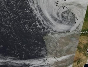
A satellite image of Cyclone Klaus on Jan. 24, 2009 over the Bay of Biscay. A new study shows there is an atmospheric circulation pattern linking severe cold spells in the northeastern United States and strong storms in western Europe.
Credit: Naval European Meteorology and Oceanography Center – US Navy
Over the past few winters, Gabriele Messori and his colleagues have noticed an intriguing weather pattern: bitterly cold days in the eastern United States were often followed by extremely wet and windy weather in Europe.
“We wondered whether this was a coincidence,” said Messori, a research scientist at the Met Office in the United Kingdom. “Most of the scientific efforts have looked at extreme events in a geographic region in isolation. We wanted to try and see if there was any obvious causal relationship between extreme events on the two sides of the Atlantic.”
Messori, then a researcher in the Department of Meteorology at Stockholm University, and his colleagues analyzed more than 100 years of data to show it is not just a coincidence – there is a link between severe cold spells in the northeastern United States and strong storms in western Europe. In a recently published study, they show there’s a common atmospheric circulation pattern linking extreme weather on the two sides of the Atlantic Ocean.
The Atlantic jet stream separates cold Arctic air from the warmer air further south. In a normal pattern, the jet stretches from the eastern United States towards the Nordic Seas.
Extremely cold winter days on the east coast of the United States are caused by an influx of cold air from the Arctic reaching further south than normal. The new research shows there is a different circulation pattern associated with these extremely cold events.
The unusual reach of the cold Arctic air corresponds to a more intense-than-normal jet stream which flattens out and reaches straight across the Atlantic toward continental Europe. This causes intense rain and wind storms several days later in places like Spain and Portugal, according to the new study.
“This link is actually a feature of our atmosphere and climate system,” said Messori, who is the lead author of the new study published in Geophysical Research Letters, a publication of the American Geophysical Union. “This is a robust relationship between different types of extreme weather.”
Messori and his colleagues are working on figuring out exactly why the jet stream intensifies, and flattens out, heading straight across the Atlantic, and how it could be affected by changes in the climate.
Knowing about this atmospheric circulation pattern could improve weather forecasts, Messori said. It could also potentially affect models used by the reinsurance industry to determine the amount of risk associated with a certain event, he said.
“It could help with the predictability of wind storms over Europe,” Messori said of the new study. “If there is a cold spell over the eastern U.S., it is statistically more likely in the coming five or six days that there will be destructive surface winds over Europe.”
— Nanci Bompey is AGU’s public information manager.


