28 May 2015
Alaska Sees Earliest 90 Degree Temperatures On Record
Posted by Dan Satterfield
From climate.NOAA.gov today:
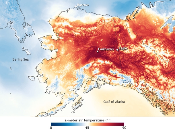
This temperature map of Alaska shows the unusual warmth on May 23, 2015, at 2 p.m. local time in Fairbanks. Based on NOAA’s Real-time Mesoscale Analysis data, it shows air temperatures at 2 meters (6.6 feet) above the ground. Temperatures below 45° are shades of blue, and temperatures above 45° are shades of orange and red.
The warmest temperatures are located inland—away from the moderating influence of the ocean—at the foot of mountain ranges and along rivers. Fairbanks, for example, is on the banks of the Tanana River in a low-lying area between the Alaska Range to the south and the White Mountains to the north-northeast.
The 91° temperature at Eagle smashed that location’s all-time record for May. It was 30.1° hotter than the average daily high temperature in May (59.5°F), and 18.1° warmer than the average high temperature in July, Eagle’s warmest month of the year. So far this month, Eagle has set or tied ten daily high temperature records.

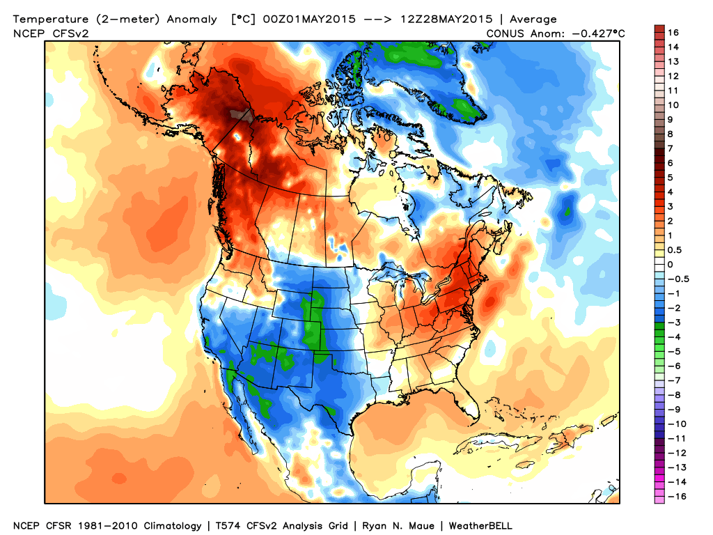
Temperature anomalies for May 2015 through the 27th. The extreme warmth over Alaska is clearly visible. Iamge ctsy. Weatherbell.
The new record edged out the previous “earliest day in the 90s” record, set on May 24, 1960, when Fort Wainwright (near Fairbanks) had a high of 92°F and Circle Hot Springs (northwest of Eagle) had a high of 90°F. The high temperature at Eagle during that heatwave was 83°F.
The stretch of the year between when the snow melts and when vegetation fully leafs out can be especially dangerous for fires in years like this, when early heat is accompanied by extremely low relative humidity. Leaf litter and other dead vegetation dries out rapidly, producing a large supply of fuel for any lightning or human-triggered fires.
According to the May 23 Fuels and Fire Behavior Advisory from the Alaska Interagency Coordination Center, the eastern interior of Alaska had very high fire risk. The same high-pressure system producing the heat and dryness was also likely to produce gusty Chinook (warm, downslope) winds. “With that combination,” the advisory warned, “very rapid spread rates and intense burning of surface fuels will cause torching and crown fire.”
Conditions were predicted to remain especially dangerous for at least the rest of the month.


 Dan Satterfield has worked as an on air meteorologist for 32 years in Oklahoma, Florida and Alabama. Forecasting weather is Dan's job, but all of Earth Science is his passion. This journal is where Dan writes about things he has too little time for on air. Dan blogs about peer-reviewed Earth science for Junior High level audiences and up.