13 September 2013
Floods Wreak Havoc Along Colorado Front Range
Posted by Dan Satterfield
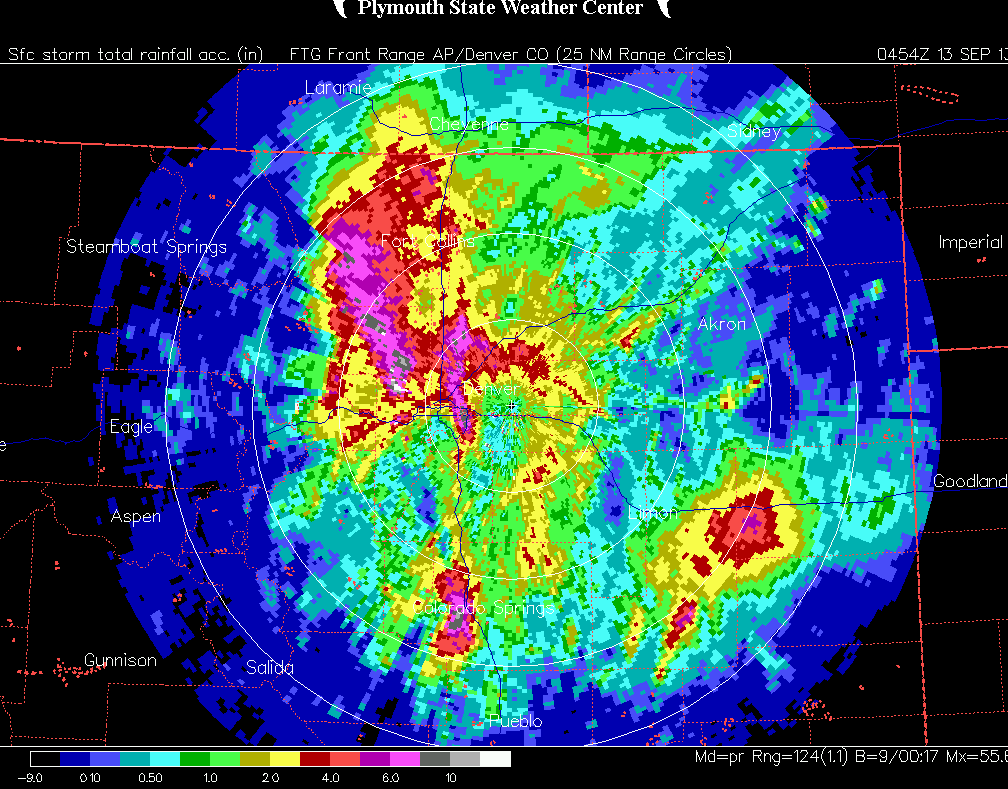
Radar rainfall estimate from the Denver NEXRAD indicates over ten inches of rainfall. Image from Plymouth State Univ. NEXRAD Archive.
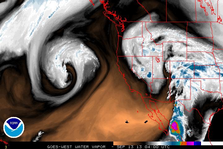
The flooding continues in Colorado tonight, and model guidance indicates there is more to come through the night. A plume of tropical moisture can be seen clearly on the GOES water vapor images, and this plume is bringing a lot of moisture straight out if the Tropical Pacific into Colorado. Up-slope winds are blowing from the Kansas prairies, where there is a load of warm moist air from the Gulf as well. As this air rises into the mountains it cools (at a rate of between 5 -10C per 1000 meters vertical), and the water falls out as heavy rains and in thunderstorms.
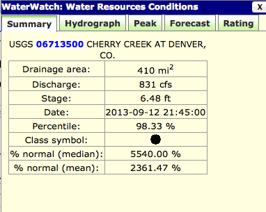
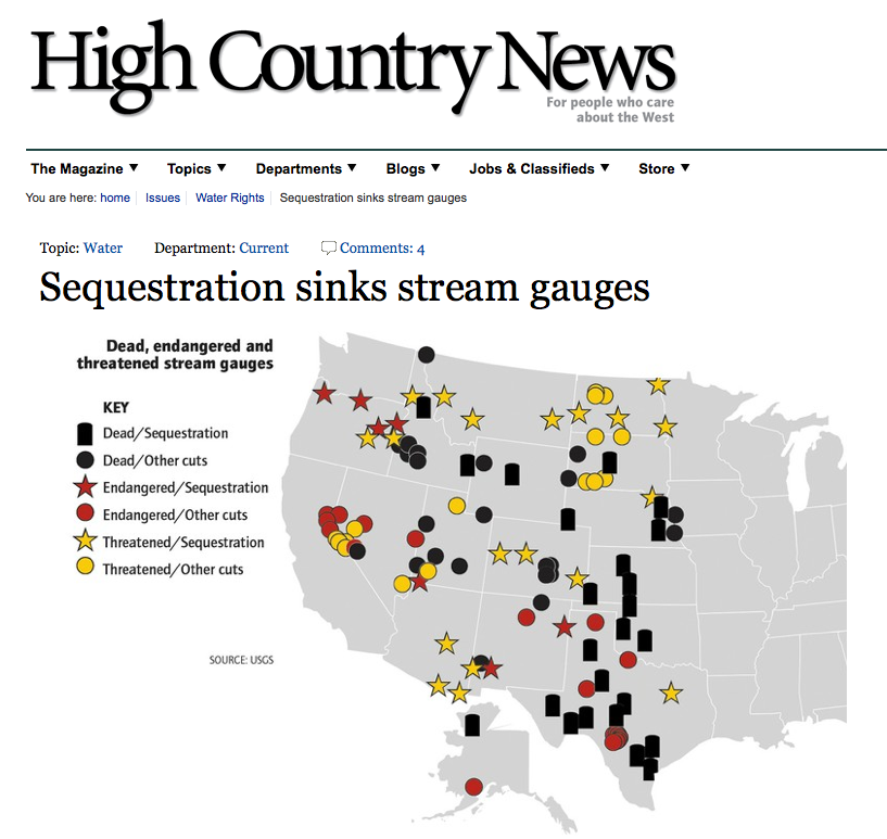
I looked up some of the real time data from the USGS stream gauges, but before I share the data, look what I read:
USGS to Discontinue Streamgages Due to Sequestration: The U.S.Geological Survey (USGS) will discontinue operation of up to 375 streamgages nationwide due to budget cuts as a result of sequestration. Additional streamgages may be affected if partners reduce their funding to support USGS streamgages. The USGS is working to identify which streamgages will be impacted and will post this information as it becomes available. Streamgages are used nationwide to predict and address drought and flood conditions by monitoring water availability.. When budget fluctuations occur, the network is impacted.
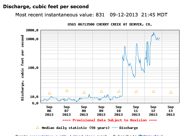 The High Country news had a story on the coming loss of the stream gauges several weeks ago…
My friend Bob Henson at the National Centers For Atmospheric Research in Boulder says the city is cut off from the outside world tonight. Rainfall today was just a half an inch shy of the ALL TIME MONTHLY record.
Just receiving news as I type this that an emergency warning has been sent out in Boulder. This is from ABC 7 News in Denver:
— City of Boulder flood alert —
A large surge of water, mud, rocks and debris, including cars, about 30 feet deep is heading down Fourmile Creek, according to an 11:10 p.m. call to Boulder County by a resident of Emerson Gulch. The flow is expected to reach Boulder Creek at about midnight.
Emerson Gulch is in the midst of the Fourmile Canyon fire burn area which was denuded of grass, trees and brush.
City of Boulder issues two emergency alerts due to rising water levels along Boulder Creek
The City of Boulder, moments ago, sounded flood sirens and sent out Everbridge notifications to a total of about 8,000 telephone numbers in two separate areas along Boulder Creek.
The first message urged individuals from the mouth of Boulder Canyon to Broadway as west and east boundaries, and within Pearl and Marine streets as north and south boundaries, to move to higher ground immediately without crossing the creek. The one exception in this area is a senior living facility at 10th and Arapahoe that is being assisted with sheltering in place on upper levels. This alert was sent to 3,495 telephone numbers.
City models show that higher ground with little or no expectation of impact on the north side of the creek means that individuals in that area should head for Spruce Street or farther north. Higher ground with little or no expectation of impact on the south side of the creek means that individuals in that area should head for all points south of Marine Street.
The second alert instructed individuals in areas along the Boulder Creek corridor east of Broadway to 75th Street to shelter in place but move to upper floors, if possible. If this is not possible, these individuals should seek higher ground, at least 12 feet above creek level, without crossing the creek. This alert was sent to 4,034 phone numbers.
Both messages were prompted by rapidly rising creek levels, water that is backing up at the mouth of the canyon due to debris, mud and water coming off the mountainsides in the canyon and current weather patterns.
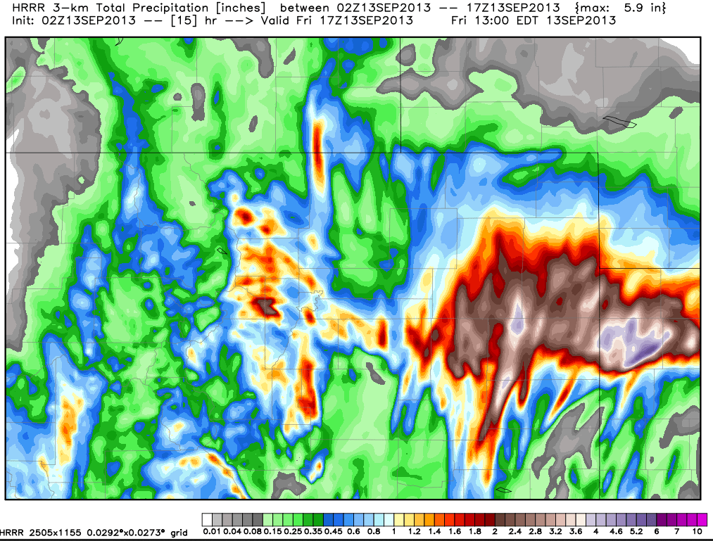
Below is the rainfall forecast from the experimental High Resolution Rapid Refresh (HRRR) model. It shows Colorado front range areas seeing overnight rainfall of over 4 inches. Scary to say the least. To all my friends in Colorado, and especially in Boulder. Be safe.


 Dan Satterfield has worked as an on air meteorologist for 32 years in Oklahoma, Florida and Alabama. Forecasting weather is Dan's job, but all of Earth Science is his passion. This journal is where Dan writes about things he has too little time for on air. Dan blogs about peer-reviewed Earth science for Junior High level audiences and up.