19 March 2012
Nation’s Icebox Is Defrosting Early
Posted by Dan Satterfield
The incredible heat has continued this weekend across much of nation to the east side of the Rocky Mountains. International Falls, which calls itself the nation’s icebox (much to Canadians amusement) has shattered record after record. On St. Patrick’s day they broke their old record high by an astounding 22 degrees!

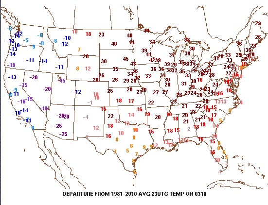
The numbers here indicate how far above (below) the current temperature was from the long-term 30 year average at 7PM EDT. on Sunday, 18 March. Image ctsy. PSU E-WALL.
Minneapolis has also broken a ton of records, and they are not alone. Chicago today hit 80 degrees for the 4th time in March, which is also a new record. So far this month, there have been about 9 record highs for every record low and it looks like this week will see even more records fall. The records will likely shift to the east coast as a strong upper level ridge builds over the region. A deep trough is moving into the west this evening, and tornadic thunderstorms are possible over the Texas Panhandle and Oklahoma.
The reason for the heat is a strong high pressure ridge that has been stuck over the central portions North America for weeks now. There are some hints that this high might weaken some, but there are other signs that it will return shortly afterwards and more records will fall through the end of the month.
As dark fell Sunday, portions of the northern plains were running 45 degrees above their average temp. for the time of day!
Here on the Delmarva Peninsula, this strong upper ridge is combining with the normally chilly March ocean temperatures to produce some amazing temperature contrasts. The high in Salisbury, MD was 65 on Sunday with sunshine, while just 30 miles away at Ocean City, there was low cloud and fog with a maximum of only 54! At 4 PM it was 19 degrees colder in Ocean City vs. Salisbury.

Dan's pic of the Wicomico River in Salisbury at 4 PM. Just 30 miles away, it was 19 degrees colder with fog on the beaches.
Anytime we get a slew of records, I get asked how this relates to climate and if this is a result of the increasing greenhouse gases. Heat waves are normal events, but the fact that the planet is warmer cannot be ignored. I wrote a piece for ATMOS-NEWS at the National Center for Atmospheric Research in February. I did a blog post on it as well here. The weather on steroids video is an excellent illustration of this subject.


 Dan Satterfield has worked as an on air meteorologist for 32 years in Oklahoma, Florida and Alabama. Forecasting weather is Dan's job, but all of Earth Science is his passion. This journal is where Dan writes about things he has too little time for on air. Dan blogs about peer-reviewed Earth science for Junior High level audiences and up.