13 December 2009
Cocktail party facts about weather and climate models.
Posted by Dan Satterfield
NASA has released this model of Earth’s weather from 9 days in last August. The model was run at a resolution of 7 km. This is a very high resolution for a global model. You can see a bigger picture of the model run HERE. It’s a stunning example of how well we can reproduce our atmosphere inside a computer!
The highest resolution weather model I look at on a daily basis for forecasting is the WRF model. (Weather Research and Forecast model). It runs in a window over North America and is not global. We get 4 runs per day at a resolution of 12km. The forecast goes out 84 hours.
So why not run them all at 7 km? Better yet make it a resolution of 4 km! Wouldn’t that give a better forecast?
Yes it would. Up to a point. (see chaos theory if you want to know why at some point you get diminishing returns no matter what)
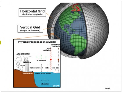
The problem with increasing the resolution means you have millions of extra cubes of data that you have to do the math for. This increases the run time of the model. A weather model used to predict the weather for the next 3 days is not much use if it takes a week to get the output!
 You can imagine it this way. Put 20 layers of sugar cubes on top of a map of the united states. The computer has to keep track of the weather in each of these cubes and using complex equations, it moves weather between cubes.
Now do it again with cubes that are half the size. You will see that it takes far more than twice as many cubes. You also have to use a shorter step in time and this more than doubles the run time!
One of the major problems with forecasting with computers is this. You have to tell the model the weather before you run it. Think about this for a second. You have to tell the model the weather in EVERY one of those cubes.
The NOAA WRF model I look at daily has more than 20 layers up to over 20,000 meters! All of them 12 km wide.
We obviously cannot afford to send up a weather balloon every 12 km! If we did, air traffic would have to come to a stand still twice a day for about two hours!
We also do not have surface weather stations every 12 kilometers apart either! So the weather is estimated using various techniques based on the data we do have. It’s amazing how close we come on most days to initializing the model with a very close approximation of the real atmosphere!
The fact that nations share their data makes it possible. Even during the cold war, we shared weather data with the Russians!
Still, the “first guess” we give the models is not perfect and this is one reason why weather models beyond about 5-7 days are not very trustworthy. The longest range model used for forecasting on a daily basis is run out to 10 days.
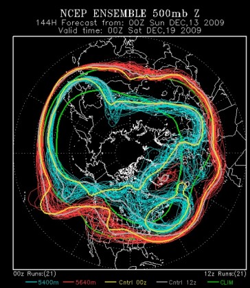
One way around this problem is to run the model several times (with very slight changes to the first guess weather) and take an average forecast. This is called ensemble forecasting and the idea is that the consensus among the models is most likely to be correct.
Research shows this to be true and there has been some very promising research on forecasting hurricane tracks using ensemble methods.

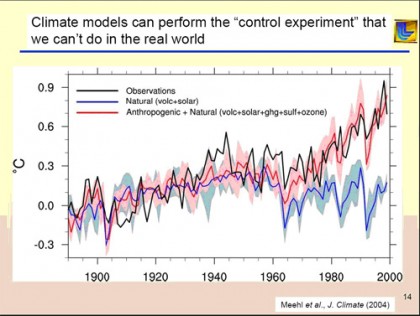
Climate models due a very good job of reproducing past temperature changes. This is why scientists are so concerned about what they are forecasting over the next 100 years.
Models used by the IPCC have a resolution of around 100 km but they are run for hundreds of years back in the past or into the future. Ensemble forecasting is also used to a great degree.
How good are these models? The graphic on the right shows a comparison of the climate model run with the actual air temperature over the past 150 years. When you want to know just the average climate, you don’t need to have the high resolution.
We don’t need to know what time it starts raining on June 4th 2098. We DO want to know how much it rains that year in a given region! This is the difference between weather and climate models.
When you put in the increasing greenhouse gases, it tracks very closely with what has happened. This is one of the major ways we know that it’s the CO2 and NOT natural changes. (Someone needs to explain this to the former Alaska governor who obviously doesn’t know it.)
The lesson to take away here is that asking a meteorologist for a forecast beyond 7 days is a waste of time. I can sometimes give a general trend out to 10 days but beyond that is simply not reliable. If you want to know the approximate time it will clear or the rain will stop, then 36 hours is really pushing it in most cases.
An error of less than plus or minus 5 degrees F. on a 5 day forecast makes me happy. Less than three degrees is excellent.
I should have charged double!
(Note I changed the name of this post slightly after publishing it initially- I just liked the new name better!)


 Dan Satterfield has worked as an on air meteorologist for 32 years in Oklahoma, Florida and Alabama. Forecasting weather is Dan's job, but all of Earth Science is his passion. This journal is where Dan writes about things he has too little time for on air. Dan blogs about peer-reviewed Earth science for Junior High level audiences and up.