
1 November 2016
Southeastern U.S. Drought Worsens as Record Heat Arrives
Posted by Dan Satterfield
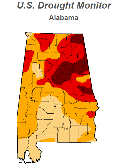
 Around 43% of Alabama is in severe or exceptional drought now. Huntsville (in North Alabama) had their hottest Halloween on record Monday with a high of 88 degrees, and it will likely be just as warm or close to it on Tuesday. The drought is a big local story, but it hasn’t gotten much attention nationally.
That may be about to change.
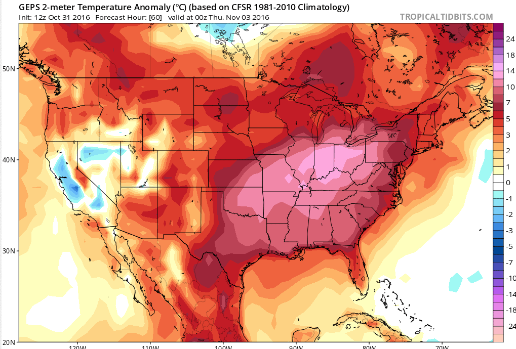
Model guidance is forecasting temperatures of over 25 degrees above normal for much of the week over the Midwest and Plains, into the South!
Records are going to tumble this week from the Southeast into Oklahoma, and up through the Northern Plains, as an intense high pressure dome develops over the region. In the South, this high pressure dome has never gone away from summer, with above normal temps. for the past two months, from Georgia to Texas, and Oklahoma into Kansas.
The image below is what Noccalula Falls near Gadsden, AL normally looks like.
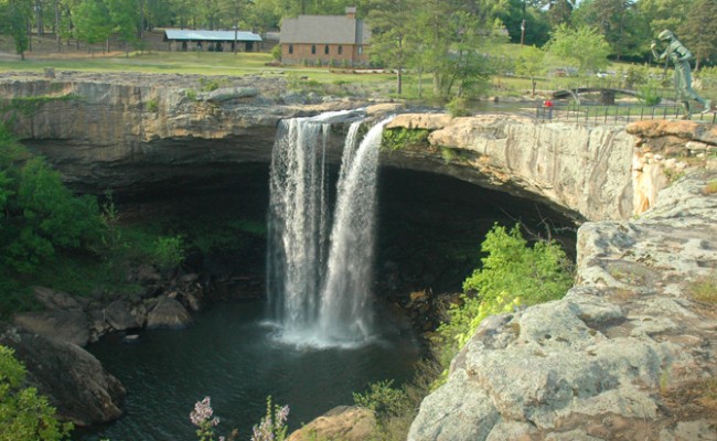
From Greater Gadsden.
The falls have been dry for three weeks now.
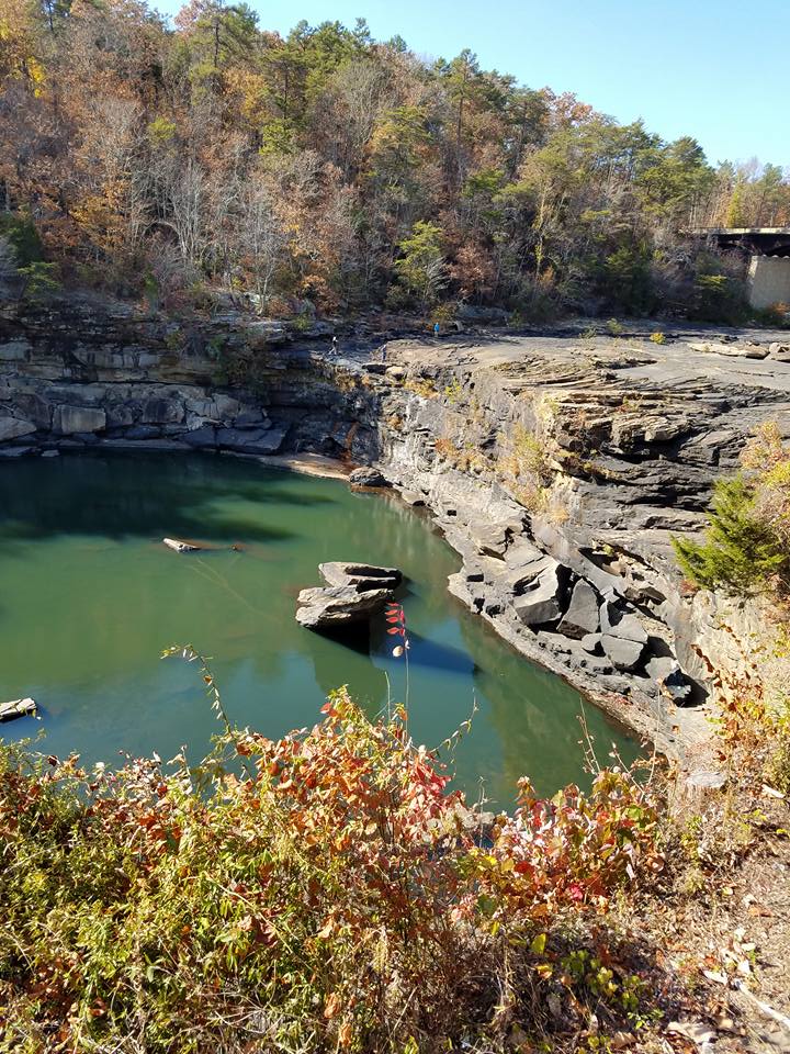
Image ctsy. Kim Briscoe
So, is there any real rain in sight for the Southeast? Look at the numerical guidance below showing rainfall over the next 7 days:
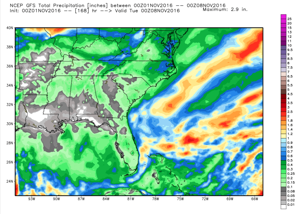
The NOAA GFS model shows only a few tenths of an inch of rain in the next 7 days. The Euro model (which I trust more) says most of the area will get none.
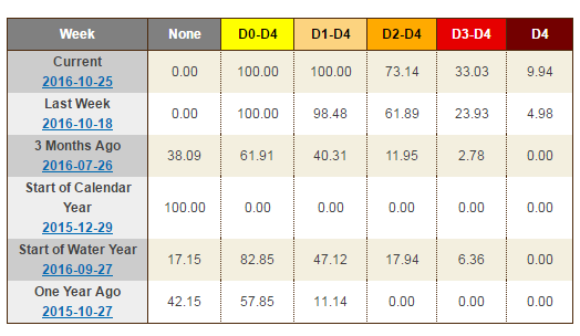
The USDA Drought Monitor summary has more info on how serious this drought is:
The Southeast
On this week’s map, most of the region saw deterioration in conditions as the dry pattern persisted. Georgia Climate Division CD 1 (Northwest), CD 3 (Northeast), and Alabama CD 2 (Northeast) all recorded their driest 60-day periods on record. Streamflow conditions continued to drop across much of the region, and drought-related impacts are being observed in the agricultural sector. Dry conditions have led to delays in the planting of winter wheat in Alabama. According to the USDA National Agricultural Statistical Service, topsoil moisture conditions (percentage rated short to very short) were as follows: Alabama – 78%, Georgia -73%, and Mississippi – 72%. On the map, areas of Moderate Drought (D1), Severe Drought (D2), Extreme Drought (D3), and Exceptional Drought (D4) expanded in both Alabama and Georgia while western portions of South Carolina saw expansion of areas of Moderate Drought (D1), Severe Drought (D2), and Extreme Drought (D3). In Upstate South Carolina, crop losses (hay) are being reported by the USDA Farm Service Agency.
Now, perhaps some good news. A major pattern change may be coming in about ten days. The long-range NOAA/Canadian Ensemble model shows much cooler air coming into the Eastern U.S. This cool down is just two days away for the Northeast, but it looks like it will expand as the Polar vortex splits, and allows chilly air into eastern areas of North America.

This may not help much with the drought in the Southeast, but it will end the amazing warmth. It will also likely bring some rain. There might be more to this story, and that is the subject of some published research in Nature Climate Change today. Could the polar vortex be responding to the dramatic loss of Arctic sea ice?? Meteorologists are talking about the unusual series of cold winters in the Northeast, and there might be a connection.
This blog post is too long already, but Jason Samenow at Capital Weather Gang wrote about just this, on Monday. It’s well worth a read, and the paper in Nature Climate Change is here. There is a lot more to talk about here, and that is the subject of a future blog post about what I think the winter will look like.
 Dan Satterfield has worked as an on air meteorologist for 32 years in Oklahoma, Florida and Alabama. Forecasting weather is Dan's job, but all of Earth Science is his passion. This journal is where Dan writes about things he has too little time for on air. Dan blogs about peer-reviewed Earth science for Junior High level audiences and up.