
5 May 2016
Roaring Inferno in Alberta is What Climate Change Looks Like.
Posted by Dan Satterfield
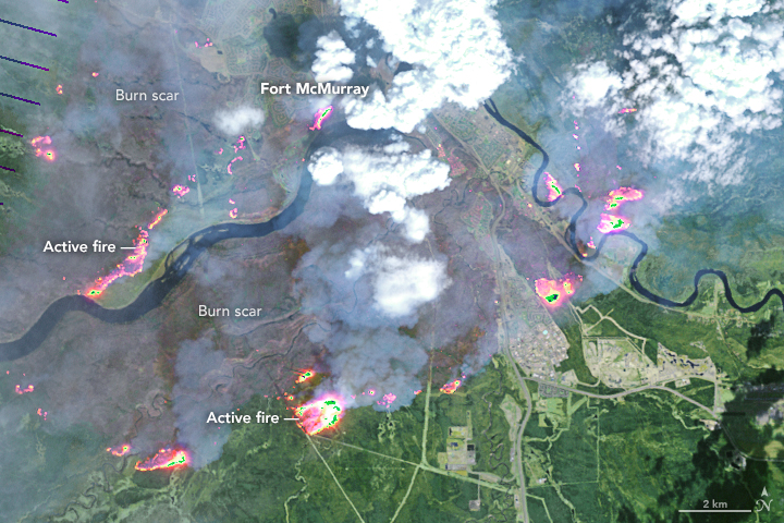
Landsat image of Ft. McMurray wildfire courtesy NASA.
The wildfire in NW Alberta grew much larger overnight and now over 85,000 people are evacuated as fire crews try to save the city. The question about how this is related to climate change is an easy one, a very easy one.
It is related, and the data backs it up.
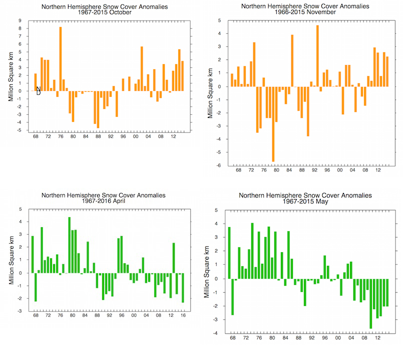
From Rutgers Snow Lab.
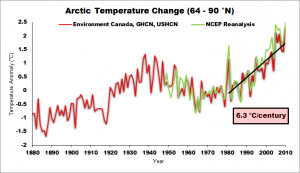
Temps. are rising very rapidly in the Arctic. Image ctsy. John Cook at Skeptical Science.
Jeff Masters (at Weather Underground) has an exc. post on this, and he posted a graph from Rutgers (see above) showing the trend in snow cover over North America in May. Look at the drop over the last few decades. The ground is warmer (and therefore drier) now in May, and this is especially so in the Boreal Forest of Canada where temps. have been rising much faster than they have in the mid latitudes.
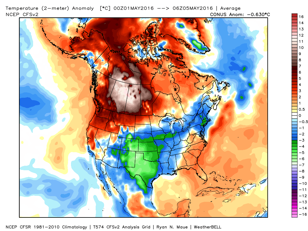
This year the fire season started very early, and temperatures in the region have been at record levels for days, with some areas reaching above 30 C! The map below shows how the first 5 days of May compare to the long-term average, and you can see that much of Alberta is running over 12 degrees Celsius above average!
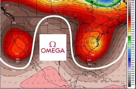 We can even drill down more, because this current weather pattern is due to what we meteorologists call an “Omega Block”. These atmospheric blocks tend to bring extreme weather to some areas for many days, like here in Maryland today, where the temps. did not reach 13 C, while it was 21 C in London! The high at Dover, Delaware Thursday was 20 degrees below average for the date, and this is what happens when you are under the cold part of an omega block. Alberta is in the warm zone of the block, and this has played a significant role in the wildfires there.
New research out this week, continues to show that these type of atmospheric blocks are becoming more common, and the loss of Arctic Sea ice may be playing a role. I’ve mentioned this in several previous posts, and Sean Sublette has more on it at WX Shift. if you think about the physics, it does make sense. Ice free oceans are warmer, and this can lead to high pressure systems in the upper atmosphere. While there is still a lot of uncertainty over the change in blocking patterns, there’s little doubt that the region around Ft. McMurray is getting much warmer, with conditions favorable to wildfire increasing as the snow goes away earlier.
 In the meantime, NW Alberta burns and the short-term weather forecast is not good. The winds will increase on Saturday, and little or no rain is likely until perhaps Sunday, when a decent cool front will come through. It looks like next week will be much cooler, as the omega blocking pattern breaks up.
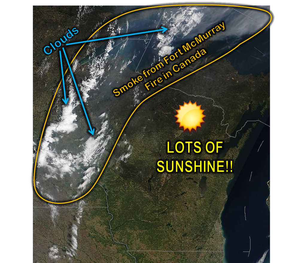
The smoke from this wildfire has been clearly visible on satellite imagery, and the NWS in Green bay Wisconsin posted an image on Twitter showing it as well. It’s likely that we’ll see more of this across Canada, and into the U.S., over the next few days.
(See below)
Some incredible pictures of the inferno, and some background, are below in a report from the CBC.
Note: I updated this post at 10:32PM EDT with the addition of a link to WX Shift.
 Dan Satterfield has worked as an on air meteorologist for 32 years in Oklahoma, Florida and Alabama. Forecasting weather is Dan's job, but all of Earth Science is his passion. This journal is where Dan writes about things he has too little time for on air. Dan blogs about peer-reviewed Earth science for Junior High level audiences and up.