
23 February 2016
Stunning One Minute Rapid-Scan GOES 14 Images
Posted by Dan Satterfield
This is the current image from the GOES-14 satellite that is in storage. It is turned on for high impact weather events because it can send one minute images. The tornado outbreak expected on the Gulf Coast today certainly ranks as a high impact event, and we should have this data through the evening. When GOES R launches we will see even higher resolution images at 30 second intervals along with lighting data!
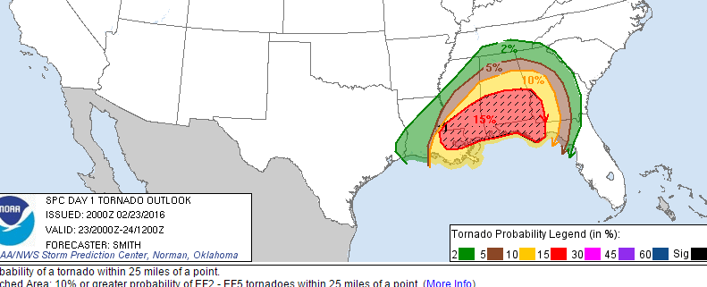
From NOAA SPC.
To see a loop of the once per minute images coming from the GOES-14 this afternoon, check out this link from the University of Wisconsin. Another link is here courtesy CIRA at Colorado State.This will give you a glimpse of the future that will arrive with GOES R. It looks quite possible that there will be a deadly tornado or two in Alabama, and/or along the Florida Gulf Coast, near Pensacola later this evening, or overnight. This storm system will bring strong winds to much of the Eastern U.S. over the next two days, as an intense low tracks into the Midwest.
 Dan Satterfield has worked as an on air meteorologist for 32 years in Oklahoma, Florida and Alabama. Forecasting weather is Dan's job, but all of Earth Science is his passion. This journal is where Dan writes about things he has too little time for on air. Dan blogs about peer-reviewed Earth science for Junior High level audiences and up.