14 August 2012
El Nino Likely This Winter- Just what that means for the winter is much more complicated!
Posted by Dan Satterfield
You’re likely to hear a lot about El Nino in the coming months, and your local TV weather guru may show graphics indicating that you will have a warmer/colder/drier/snowy winter as a result. Don’t believe it, (at least hook, line and sinker) because it may very well turn out to be wrong. There are a lot of factors that will play a role on the upcoming winter in the Northern Hemisphere, and El Nino is just one of many!
What El Nino Really Is
El Nino is an ocean-atmosphere pattern that naturally develops every few years, and It’s characterized by a warming of the ocean water in the equatorial Pacific. This warming is caused by a change in the strength and direction of the winds in the Pacific. The winds usually blow from east to west and push the warm surface water back toward Asia. This brings up cold water from the deep along the coast of South America, while the warm water in the western Pacific actually piles up making sea level 20-30 centimeters higher there than on the coast of South America!
NASA has a great video about El Nino here ( a bit old but still spot on)
< >
When the winds weaken, that water starts sloshing eastward and eventually the waters off the coast of South America become much, warmer. This warm water warms the atmosphere and this causes a significant shift in the storm tracks around the World. Since El Nino’s tend to peak in the winter months, this shift in the storm track, can make it possible to say at least something about how the winter will go compared to normal.
SOMETIMES!
By The Numbers
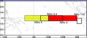
To officially be called an El Nino, there is a specific set of rules that must be met, and these rules revolve around an area of the Pacific called the Nino 3.4 region. Here’s the way it works:
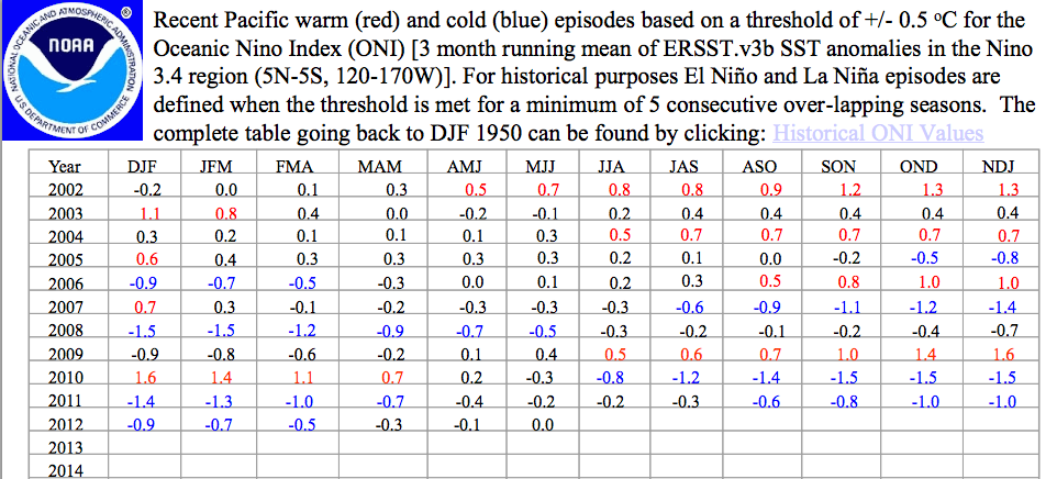
1. You take the sea surface temperature (SST) average in the Nino 3.4 region for a month and compare it with the temperature there in the previous two months. 2. If the average is above normal by 0.5 degrees Celsius when you average the present month and the previous two months, you have an El Nino.
To be a full-fledged bouncing baby El Nino, this anomaly must continue for 5 overlapping consecutive 3 month periods. The average temperature over the past 3 months for the Nino 3.4 region has a name. It’s called the ONI or Oceanic Nino Index ( Hey NASA has nothing on we weather geeks!). The image below is the ONI index up to this most recent month:
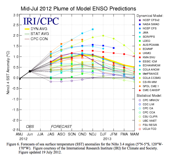
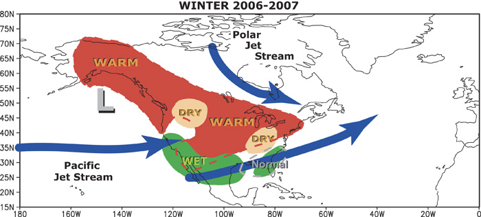
The dynamical models (and some of the statistical models, see the image at the top fo this post) are predicting that we will enter a full-fledged El Nino by autumn, and that it will continue through the boreal winter. The next question is whether it will be a weak,moderate, or perhaps even a super El Nino (like the big event in 1998) is on the way, and that makes a big difference on the kind of weather we will see from this event. That said, the map below shows what an average El Nino does. THIS IS THE MAP I WARNED YOU TO TAKE WITH A GRAIN OF SALT at the beginning of this post!
Something to remember here is that people do not remember the climate of the last winter; They remember the WEATHER of the past winter. Chicago usually has a mild winter in El Nino years, when you average it all out. However, if they have 3 blizzards surrounding slightly warmer weather than normal, the average guy on the street is going to insist that the forecast of a milder than normal winter was baloney! I’m especially sensitive to these kind of issues, because I have forecasted weather on TV for 32 years, and have had plenty of accurate forecasts that viewers saw much differently!
An interesting paper in the June issue of the AMS Journal of Climate by Siegfried Schubert ,Yehui Chang and Max Suarez from NASA’s Goddard Space Flight Center took a look at the SNOWMAGEDDON winter of 2010 and concluded that the combination of a weak El Nino and a negative pattern in the North Atlantic Oscillation were instrumental in the heavy snow events. The negative NAO, caused unusually cold weather to combine with the stormy weather of El Nino, and bring snow instead of rain.
This winter could bring a repeat of such and event, but if the NAO is more positive, then it may be a winter of cold, windy rain storms instead of blizzards. The point here is that every El Nino is different, and other atmospheric and ocean oscillations will play a role. In general, it will probably turn out mild in the northern plains and there will be an active storm track along the gulf coast. There is also some indication that a weak to moderate El Nino produces more snow than a strong one over the East Coast. Another good read with a bibliography of excellent sources at the end of it is here. My friend Bob Henson at NCAR has some interesting info for those of you in Colorado on this subject as well.
The same reasoning applies to years when a La Nina is present, and I wrote about this last year along with more info on other ocean-atmosphere patterns.
UPDATE AUG 15: The maps (I warned you above to be wary of) have already started appearing. Jason Samenow at Capital Weather Gang has a great post about it as well. Check out how much the snowfall varies during El Nino years in the Washington area.



 Dan Satterfield has worked as an on air meteorologist for 32 years in Oklahoma, Florida and Alabama. Forecasting weather is Dan's job, but all of Earth Science is his passion. This journal is where Dan writes about things he has too little time for on air. Dan blogs about peer-reviewed Earth science for Junior High level audiences and up.
My dear old mom just asked what kind of winter we will have. I mentioned there may be an El Nino coming in, and she replied along the lines of, “Well it won’t be as cold, but we’re going to get snowed in again”.
In general, she’s right (but haven’t checked this myself with weather data so confirmation bias alert). We don’t have the -40 C days, although it may for a day or two go just below -30 C. But we often have so much wet heavy snow I can’t shovel it out of her driveway so have to find a snowblower. In an El Nino year I need a snowblower several times during the winter. In a normal winter I won’t need a snowblower at all (or just once).
I remember this because I greatly dislike using noisy machines and much prefer to shovel quietly and take time to listen to the woods while I shovel. (I also remember it because I have to get up very early and head off to my mom’s to shovel her out so she’s not trapped for the day).
I still have many questions. One being, would anyone have ANY clue if its gonna be cold here in Florida?! Last between quotes “winter”, was the hottest i ever experienced! So hot that i wouldn’t have felt uncomfortable walking outside shirtless! I’m fed up with this! One hot winter to later come accross an even hotter summer! PLEASE make my day and tell me there’ll be a colder winter this year down here!
my question still hasn’t been answered!!!!!!
what might el nino cause his winter?