10 July 2012
Last 12 Months In U.S. Are Warmest On Record. (A 1 in 1.59 million event)
Posted by Dan Satterfield

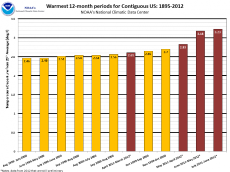
From NOAA NCDC: These are the warmest 12-month periods on record for the contiguous United States. During the June 2011-June 2012 period, each of the 13 months ranked among the warmest third of their historical distribution for the first time in the 1895-present record. The odds of this occurring randomly is 1 in 1,594,323. The July 2011-June 2012 12-month period surpassed the June 2011-May 2012 period as the warmest consecutive 12-months that the contiguous U.S. has experienced.
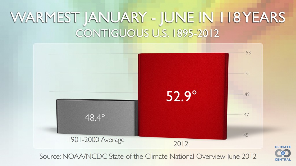
The NCDC released the June temperature data today and while it was the 14th warmest on record, added to the 5 months before it make the first six months of the year the warmest on record. Not only that, but it is also the warmest 12 consecutive months on record. We still had a La Nina back in the fall so the warmth of the last 12 months worldwide is even more unusual.
Indeed, a developing El Nino may indeed push the global temperature to a new record by the end of this year or next.
The number of all time temperature records broken in June is truly stunning, and if you look at the warmest 12 month periods on record, 12 of them have happened since 2000. In the past year there have been more than 37,000 record high temps. in the U.S. and around 6,000 record lows.
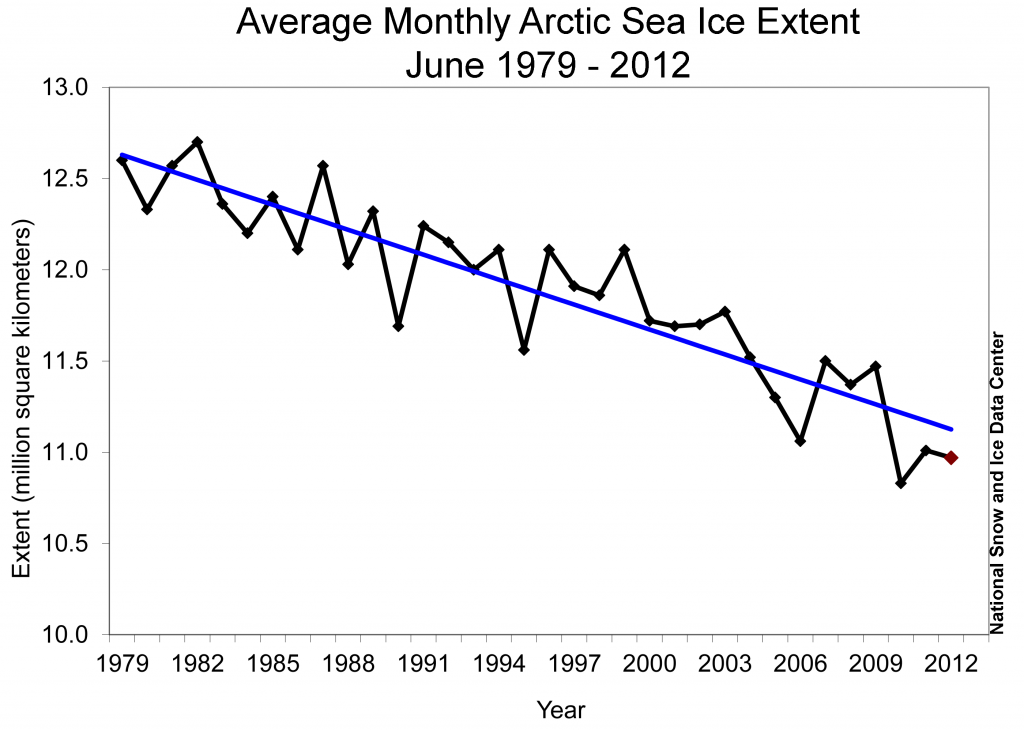
The summer melt season in the Arctic is well underway and the NSIDC had updated the June numbers as well. A new record low seems in reach.
Here is what the ice experts at the National Snow Ice Data Center had to say on the melt so far this year:
Overview of conditions
Arctic sea ice extent for June 2012 averaged 10.97 million square kilometers (4.24 million square miles). This was 1.18 million square kilometers (456,000 square miles) below the 1979 to 2000 average extent. The last three Junes (2010-2012) are the three lowest in the satellite record. June 2012 ice extent was 140,000 square kilometers (54,000 square miles) above the 2010 record low. Ice losses were notable in the Kara Sea, and in the Beaufort Sea, where a largepolynya has formed. Retreat of ice in the Hudson and Baffin bays also contributed to the low June 2012 extent. The only area of the Arctic where sea ice extent is currently above average is along the eastern Greenland coast.
The ice extent recorded for 30 June 2012 of 9.59 million square kilometers (3.70 million square miles) would not normally be expected until July 21, based on 1979-2000 averages. This puts extent decline three weeks ahead of schedule.


 Dan Satterfield has worked as an on air meteorologist for 32 years in Oklahoma, Florida and Alabama. Forecasting weather is Dan's job, but all of Earth Science is his passion. This journal is where Dan writes about things he has too little time for on air. Dan blogs about peer-reviewed Earth science for Junior High level audiences and up.
We miss you in Huntsville.