23 January 2012
Two Dead In Birmingham, Alabama Tornado
Posted by Dan Satterfield

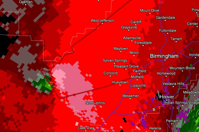
This is a Doppler velocity image showing winds toward the radar (green) and high winds away from the radar in pink. The strong winds (toward and away) so close together indicate an intense rotation. It was rather close to the NOAA radar site so the beam intercepted the storm at just a few thousand feet off the surface.
 An EF 3 tornado (winds near 240 km/hr/150 mph) hit Jefferson County Alabama early Monday morning (see previous post). Two are dead, and the damage is quite severe with over 100 injuries. The tornado hit in the middle of the night, when many people were asleep.
It was a good bet that there would be a deadly tornado somewhere late Sunday into Monday, because the upper level storm system was very energetic. If you draw a line through the trough, it has a backwards slant. Meterorologists call this a negative tilt trough and this tends to make the wind shear in the atmosphere very favourable for strong tornadoes.
Tornados require two main ingredients: wind shear and instability. Most often, a winter time outbreak has low instability and very high wind shear. That was the case in this event, and once agin confirms a forecast rule I was taught 30+ years ago. Always beware of a negative tilt trough.


 Dan Satterfield has worked as an on air meteorologist for 32 years in Oklahoma, Florida and Alabama. Forecasting weather is Dan's job, but all of Earth Science is his passion. This journal is where Dan writes about things he has too little time for on air. Dan blogs about peer-reviewed Earth science for Junior High level audiences and up.
We have a lot to be thankful for bacsuee we did not have any damage where I live but we are praying for you people who lost everything,I do not know how bad it is and hope and pray I never do but we wan’t you to know we are praying God will provide your needs and nothing is impossible with Him.May God bless you.Bonnie Swafford