
4 September 2011
Quick Update on Tropical Storm Lee
Posted by Dan Satterfield
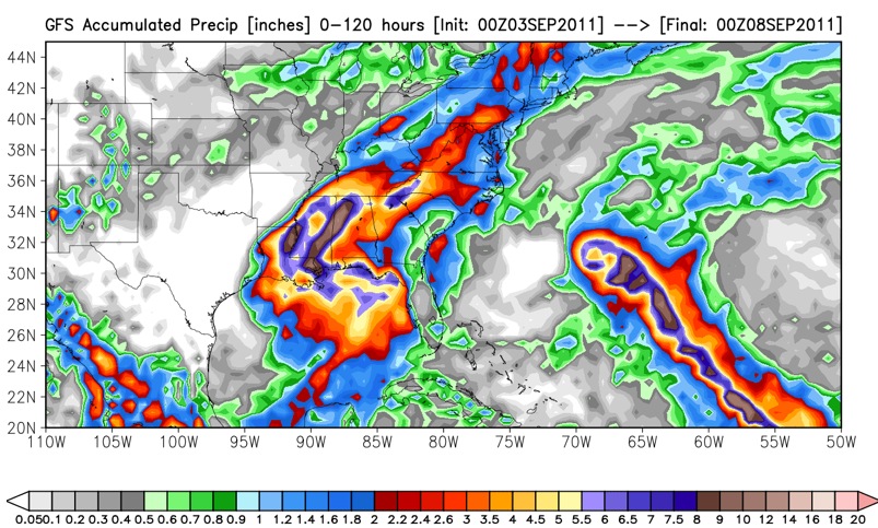
NWP models are still indicating very heavy rains from LA into East TN. Click for full res. Ctsy. Ryan Maue at FSU.
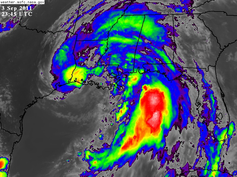
GOES images from NASA still show intense convection on the Gulf and this leads me to believe in the NWP predictions of extreme rainfall.
TS Lee is dumping very heavy rains along the coast tonight and moving very slowly onshore west of Baton Rouge, LA. The heavy rains are forecast to move into central AL on Sunday and then into North AL (my location) by Sunday night. While the winds may never allow Lee to be called a hurricane, the strong Canadian high pressure system moving down from the north may give 40 kt. winds to much of North AL by Monday. The wind is based on the difference in pressure across an area and even of the remains of Lee are not that strong, the pressure gradient between these two systems may be intense.
The track forecasts are in good agreement and take Lee into NE Alabama by late Tuesday, but I am not convinced it will move as fast as they indicate, especially later in the period. If it stalls, this will increase rainfall and could still cause severe flooding. The greatest threat of this happening is in Alabama, the way it looks now.
Scott Bachmeier at the CIMMS satellite blog has some more info on Lee here. A must read for fellow remote sensing fans.
 Dan Satterfield has worked as an on air meteorologist for 32 years in Oklahoma, Florida and Alabama. Forecasting weather is Dan's job, but all of Earth Science is his passion. This journal is where Dan writes about things he has too little time for on air. Dan blogs about peer-reviewed Earth science for Junior High level audiences and up.
THANX, DAN. LOOKS LIKE OUR RETURN TRIP FROM B’HAM TUE WILL BE BY BOAT. SURE HOPE IT WAITS TILL WE GET TO SCOTTSBORO. BUT NATURE WAS STARTED BY GOD FOR A REASON AND WE DON’T ALWAYS UNDERSTAND THE “BALANCE”. SEEMS LIKE THIS PART OF THE COUNTRY IS IMBALANCED RIGHT NOW. WHO ARE WE TO QUESTION GOD’S DESIGN?
MAY GOD BLESS YOU & YOURS . MY PREDICTION IS WE WILL GET HOME SAFE, WET & SOUND. (LOL)
Will there be significant rainfall over Texas and Oklahoma?