
24 August 2011
Quake Waves Travel Across U.S. and Irene Strengthens
Posted by Dan Satterfield
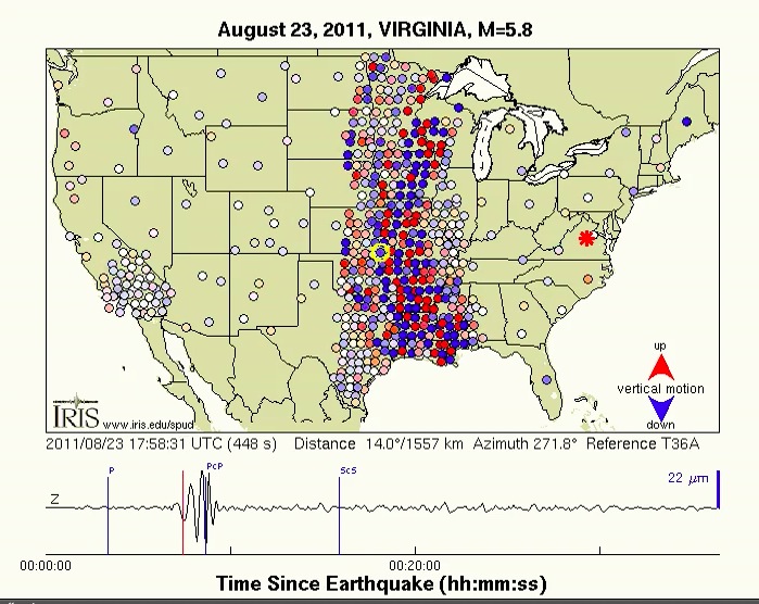
Callan Bentley over at Mountain Gateway here on the AGU Blogosphere has the best post on the net about the quake in VA. I saw the link to this video in the comments section, and it’s well worth a view. It’s from the Iris Transportable Array.
 First the quake and now possibly a hurricane?
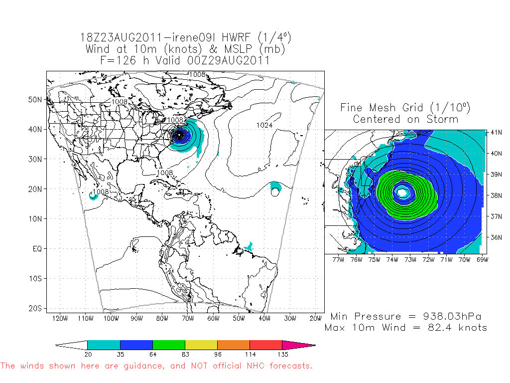
NWP Guidance this evening is indicating that Irene may skirt the Outer Banks and then come ashore in New Jersey. This would put Philly, NYC and Boston on the windiest side of the storm and cause significant damage.
The Hurricane Weather and Research(WRF) Forecast model is indicating an intense storm approaching New Jersey in 5 days. Hurricane hunters have measured a pressure at 969 mb tonight and looking at the thermal IR sat pics here in the weather office, an eye is beginning to form. We may have a category three storm by morning headed to the Bahamas. Keep in mind that NWP models are just guidance and other models are keeping the storm off the coast.
The reason I think this is not likely to be the case, is due to the trough in the upper atmosphere that is turning Irene northward. It will lift out by Thursday and this will allow a northward motion to continue. Hurricanes are steered by the rivers of air in the atmosphere and the worst case scenario is a moderately fast-moving storm going through western NJ. It would affect the highest population center of the U.S. and cover a lot of ground before the winds weaken.
Update 12:23 am EDT: The evening NWP models are shifting a bit further east and it is still possible that the NE will be on the safer western side of Irene. Sometimes the change from run to run is a clue that the actual track will continue to shift eastward.
 Dan Satterfield has worked as an on air meteorologist for 32 years in Oklahoma, Florida and Alabama. Forecasting weather is Dan's job, but all of Earth Science is his passion. This journal is where Dan writes about things he has too little time for on air. Dan blogs about peer-reviewed Earth science for Junior High level audiences and up.
Check that blog title… 🙂
Thnx! I’ve been around too many TV news tease writers 😉
Dan, I hope you and a lot of others are asking what the melting of polar ice will do to tectonic plate movement. It seems to me you can’t shift the weight of all that ice and not get more earthquakes. Hopesomeone is studying this.
Sea ice is just frozen water and so when it melts, there is no mass change, what was ice is now water. It also does not change the height of the sea. Ice on land is different, and much of northern Canada is still rising from the disappearance of the mile of ice that was on top of it in the ice age. The term for this is isostatic rebound. It makes measuring sea level globally rather difficult!