
18 June 2011
An MCC Is The Farmers Friend
Posted by Dan Satterfield
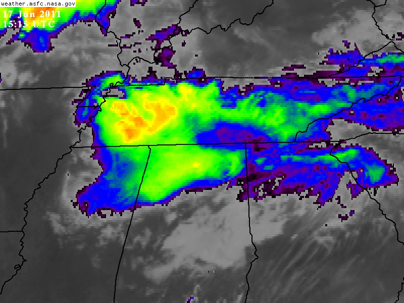
An MCC over North Alabama on Saturday. It produced widespread rains that were very welcome by farmers. Image ctsy. NASA GHCC.
We just ended a pretty serious drought here in the Tennessee Valley, with no rain from late May until Friday June 17. Normally, we would have had about 2.5 inches in this period, and this long without rain in the unusually high heat was especially hard on crops. Twenty days with no rain is not a big deal in winter (when it is cold and evaporation rates are very low), but in summer heat, that kind of dry stretch will dry out the ground very rapidly.

A trailing stratiform MCS over North Georgia Saturday Afternoon June 18,2011. HTX NOAA NEXRAD radar image.
The corn and cotton crops were saved by what forecasters call and MCS, which stands for mesoscale convective system. These were first formally identified in the literature by Maddox back in 1980 who noticed that a large amount of rainfall in the plains during the warm season came from these huge long-lasting clusters of thunderstorms. It is thought that somewhere around 30-70% of summer rains are from these systems in the Plains, and I personally think that here in the Southeast (in the summer) it is well above half.
They truly are the farmers friend because they bring widespread soaking rains that last several hours. Even after they pass, the clouds will linger for much of the day and keep evaporation rates lower, allowing the rain to sink in to the soil. A typical MCC can bring 1-3 inches of rain to an area and sometimes more.
The official definition of an MCS in the AMS Glossary of Meteorology is this:
mesoscale convective system—(Abbreviated MCS.) A cloud system that occurs in connection with an ensemble of thunderstorms and produces a contiguous precipitation area on the order of 100 km or more in horizontal scale in at least one direction. An MCS exhibits deep, moist convective overturning contiguous with or embedded within a mesoscale vertical circulation that is at least partially driven by the convective overturning.
Sometimes meteorologists use the terms MCS and MCC interchangeably but a Mesoscale Convective Complex is a special type of MCS. MCS’s can include squall lines, bow echoes and Mesoscale Convective Complexes.
The AMS Glossary definition of an MCC is different:
 In short, these are huge systems and what is even more interesting is that they like to develop in the late evening, and last 6-12 hours. They will sometimes travel over 400 miles and dump tremendous amounts of rain. They usually will die out around 8-11 am but will leave a bubble of cool air that will reignite again later that evening. Forecasting their movement is also not at all straightforward. Normal thunderstorms will move along with the average wind between 850 and 300 mb. MCC’s get much of their fuel of warm moist air from a low-level jet that develops at night, and they tend to redevelop in the direction it is coming from.
Stephen Corfidi of NOAA’s Storm Prediction Center in Norman, is famous for developing the technique of Corfidi vectors to forecast the movement of these systems and his method works very well (one of his famous papers is here). Wikipedia has a nice article on MCS’s as well with a bunch of links to some exc. papers on the subject.
 Dan Satterfield has worked as an on air meteorologist for 32 years in Oklahoma, Florida and Alabama. Forecasting weather is Dan's job, but all of Earth Science is his passion. This journal is where Dan writes about things he has too little time for on air. Dan blogs about peer-reviewed Earth science for Junior High level audiences and up.
Hi Dan…that MCS on the 17th left 3″ of rain by 6AM at my place on Green Mountain using a weather channel rain gage and then there was another 0.7″ later that morning for a total of 3.7 inches!!! Just thought you’d like to know about that.
Barb
Amazing how much rain they can produce Barb and they tend to come in a cycle when the right pattern sets up. NW winds aloft usually does it for the TN Valley but it varies across the World.