
26 April 2011
Storm Prediction Center Issues Rare “High Risk” of Severe Storms
Posted by Dan Satterfield
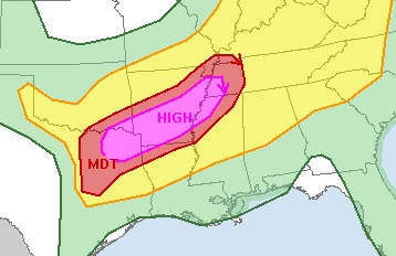
SPC High Risk Area- from NOAA
There are two main ingredients for severe thunderstorms, wind shear and instability. These long lasting thunderstorms called supercells produce almost all of the severe weather that hits the plains and Southeast USA in the spring. If you have large hail or see a tornado, then you are in a supercell.
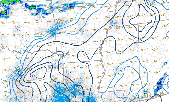
- Meteorologist combine instability and shear into an number called the supercell index. Anything above 5 is significant, and over 10 is a bad day. This image from NOAA SPC at 2 PM Tuesday 26 April. Notice the 20 in NE TX!
Supercells can develop with a lot of one ingredient and a little of another, but the really big tornadoes are usually only seen on days when the instability is very high and the wind shear is also very strong as well. Severe weather forecasters measure instability in different ways but the most popular is a term called CAPE, which stands for Convective Available Potential Instability. It’s really a measure of the potential energy available to be released in the atmosphere.
Wind shear is the change of velocity with height. Notice here, I said velocity and not speed. In physics, velocity is a vector quantity which means that not only is the speed important but the direction is as well. A high risk day will have winds getting stronger with height and changing directions in such a way as to produce storms with separate updrafts and downdrafts. Separating the updrafts and downdrafts leads to long lasting environmental storms that can produce severe weather over a large area for many hours.
It’s going to be a mean night in Texas and southern Arkansas. If you live in these areas, you should know that there will likely be several EF3 or higher tornadoes in the next 12 hours. The Storm Prediction Center, has just issued an even more rare PDS Tornado Watch. PDS stands for Particularly Dangerous Situation.
It is.
Dan
 Dan Satterfield has worked as an on air meteorologist for 32 years in Oklahoma, Florida and Alabama. Forecasting weather is Dan's job, but all of Earth Science is his passion. This journal is where Dan writes about things he has too little time for on air. Dan blogs about peer-reviewed Earth science for Junior High level audiences and up.
So does that mean that Northwest Alabama is in the clear for the rest of the day?
Dan…things are looking very bad for the tenn. Valley on wed. What is you thoughts on north al. Specially north al.
Thank you
Valorie
Is the going to move across north AL?
Main threat for AL and TN is Wednesday.
I wonder what kind of sirens they have in the midwest. Wheelens? 2001s? Thunderbolts? Thunderbeams? ACA Allertors? Mobil Directoes? P-50s? EOWS 612s? EOWS 812s? EOWS 408s? E57s (a german siren)?
Visit my blog, please. http://2001siren.edublogs.org