
7 March 2011
Spotting A Tornado On Your iPhone
Posted by Dan Satterfield
 There are some fabulous apps now for mobile devices (like the iPhone and iPad) that give you real-time radar images. So here is a blog post on how to do some basic interpretation of what you are looking at, and whether or not it is dangerous. In other words, is that blob of red on my iPhone likely to blow me away!
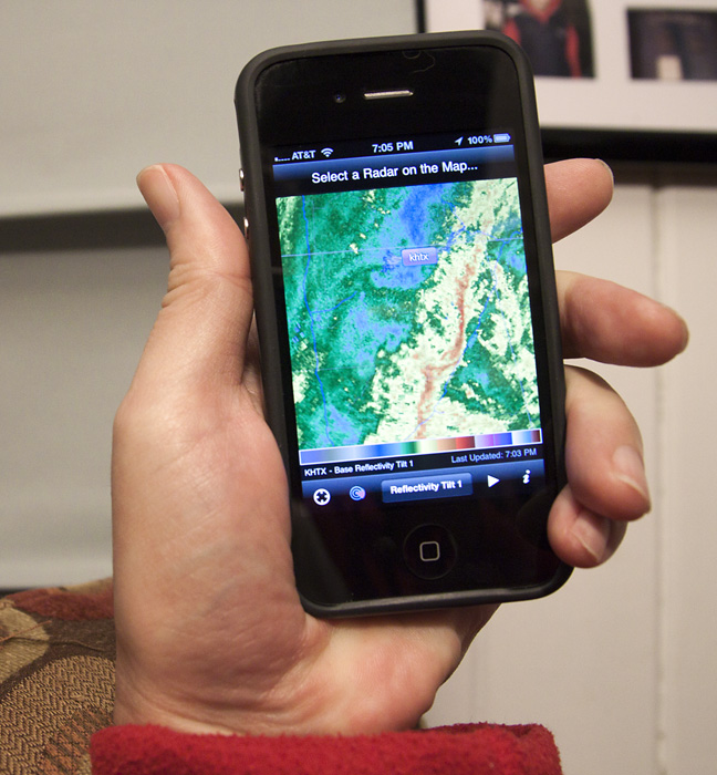
First, what app should you get? After reading this, you should have enough of an understanding to want something really decent, and that means getting Radar Scope. It’s available for iPhone and iPad and is by far the best out there. Every meteorologist I know has it! It’s not expensive and it’s worth every penny, especially if you are outside a lot or travel frequently. ( I have no connection with the makers)
Radar Scope is 410 and you can get it here. It will give you real time data from every NOAA Doppler NEXRAD radar in the U.S. Even those in southern Canada around Toronto or Vancouver can get good coverage from them.
Before I show you some examples of what bad things look like on weather radar, some basic facts:
The NOAA Doppler radars constantly scan at several different elevations. The base reflectivity image on Radar Scope will usually be the 0.5 degree elevation.
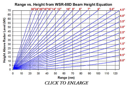
Radar beams travel in straight lines, but the Earth is round (I hope that doesn’t come as a shock). The further a storm is from the radar, the higher the radar beam is seeing it. A storm 150 km away is going to show up on radar, but you will be looking at the storm at an altitude of around 2 km, not near the ground.
This can be important since you are worried (I assume!) about the weather near the ground. The exception is a pilot who cares about avoiding the whole storm (if it’s stronger than a moderate rain shower).
The radar beam gets bigger as it goes out and this means the resolution decreases with distance. Think of a really good flashlight shining a spot on a nearby wall. It makes a much bigger and considerably weaker spot on the house next door. This means you should use the radar nearest to the storm, if you are wanting to know how dangerous it may be.
A tornado is very difficult to see on radar beyond about 100 km. A weak tornado is almost impossible to see beyond that range. However, a large deadly EF 5 will likely show up at 150 km away. One reason is that the radar beam overshoots the key part of the storm, and the other has to do with range limitations on seeing the wind flow inside the storm. If math does not scare you, see the Doppler dillema.

This is one of the Volume Coverage modes of the NOAA Doppler radar. The radar takes about 5 minutes to look at 14 different tilts. This allows forecaster to see much more of a storm.
Radar Scope gives you more than just the reflectivity display you see on TV weathercasts, it actually gives you several products that meteorologists like myself use when tracking storms. You will see tilt 1, tilt 2, etc. on the radar scope menu and this refers to the volume coverage pattern (VCP) the radar is running. Most often tilt 1 is 0.5 degrees and tilt 2 is either 0.9 or 1.5 degree elevation. This can change, and a great summary of all the VCP’s is here.
Now that you have the basics down, how do you interpret what you are seeing?
Let’s start with the colors. Blue and green are usually light rain and yellow and red are heavier. Red could be hail if there are strong storms about. One thing to be careful of here.
Anomalous Propagation.
It’s not some strange disease, but it can make you think heavy storms are developing when there is nothing but clear skies!

None of this is rain. It's called A.P. by meteorologists.
Anomalous Propagation (AP to meteorologists) happens when the density differences in the atmosphere cause the radar beam to be bent toward the ground. This happens frequently on clear, calm nights with strong temperature inversions. I was once awoken by a producer at 3 am telling me I needed to come into work quickly. She thought giant storms were developing!
I patiently explained that there was nothing but clear skies over Central Florida at the time, but you don’t need to make that mistake! If in doubt, look at a radar loop (radar scope has this feature). Storms usually move and AP does not. It also usually looks circular around the radar beam.
Sometimes AP will appear as linear spikes parallel to the radar beam. The example to the right shows both cases. With AP, the best advice is to use some common sense. It usually looks different than rain and thunderstorms.
In Part two, I’ll show you some examples of squall lines and tornadic storms. Some echoes that look dangerous are not, and others that look safe are dangerous. Knowing the difference can give you some piece of mind (or give you impetus to to shelter in a hurry).
 Dan Satterfield has worked as an on air meteorologist for 32 years in Oklahoma, Florida and Alabama. Forecasting weather is Dan's job, but all of Earth Science is his passion. This journal is where Dan writes about things he has too little time for on air. Dan blogs about peer-reviewed Earth science for Junior High level audiences and up.