
10 January 2011
North Alabama Buried in Snow-Again!
Posted by Dan Satterfield

I thought I’d share with you some of the images viewers sent in of the heavy snow event over North Alabama. In Huntsville, this is the third heaviest snowfall on record. Number one is the 17 inches that fell on New Year’s Eve in 1963. January 1988 brought 9.6″ and the total last night was 8.9″ at the Huntsville Airport.
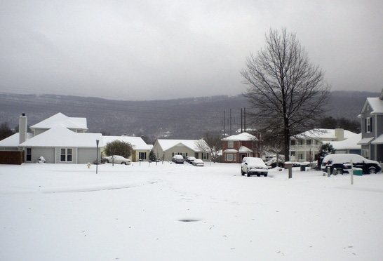
This event comes just 3 weeks after a very rare white Christmas over the region! Two heavy snows like this in one winter are almost unheard of here. It’s now the 3rd snowiest winter on record for North Alabama. Atlanta has been virtually shut down by snow and ice with hundreds of flights cancelled at Hartsfield Airport.
Most snow events in the South have a ratio of liquid water to snow of less than 10 to 1. This one seems to have been more like 11 to 1. The ratio is affected by temperatures aloft.

This is near Fort Payne Alabama.
Here is another shot of the snow. The highest totals seem to be near Florence in NW Alabama where 11 inches fell.
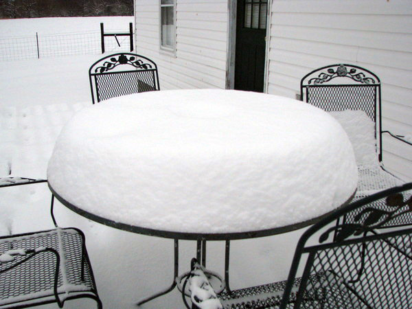
This shows well the depth of the snow.
Wes Junker, a legendary forecaster for NOAA, at the Hydrometeorological Prediction Center (HPC) has some good info on the snow to liquid ratio. This gives you an idea of how difficult forecasting snowfall can be:
Forecasting snow to liquid ratio
Summary
Warm ground and boundary layer temperatures can keep snow-water ratios down
*
a warm layer that approaches zero oC also will usually keep the ratios low.
*
Storms having clouds with a large amounts of supercooled droplets will not have as high a ratio as storms in which most crystal growth is by deposition.
*
Soundings that are almost isothermal with a large portion of the sounding near zero oC will usually have a ratio of 8 or 10 to 1.
*
High winds will keep snow ratios down because snowflakes will fracture and lose their lacy structure
*
Deep cold air promotes higher ratios but if the temperatures are too cold the crystal type may not be conducive to high ratios. .
*
Storm tracks often provide keys to forecasting the snow to water ratio
tracks near oceans have more liquid water in clouds which usually produces lower snow-liquid ratios
Looking at Monte Sano Mountain in Huntsville.
My initial forecast was for 4-9 inches. I revised it up to 7-13 inches during the event.
5 to11 inches was reported in most areas.
UPDATE:
Cool time-lapse video of the snowfall in Madison Al. (Just west of Huntsville):
 Dan Satterfield has worked as an on air meteorologist for 32 years in Oklahoma, Florida and Alabama. Forecasting weather is Dan's job, but all of Earth Science is his passion. This journal is where Dan writes about things he has too little time for on air. Dan blogs about peer-reviewed Earth science for Junior High level audiences and up.
Great job as always Dan! I don’t start listening to weather forecasts until you start talking…….then I listen for Aaron to confirm……. 🙂 This is truly an amazing winter here in N. AL.
well dan do u think this will be all the snow we will recieve or does the rest of the winter look like we will stay cold.
[…] This post was mentioned on Twitter by adamjones and Peggy Long. Peggy Long said: RT @wildweatherdan: North Alabama buried in snow-AGAIN! http://bit.ly/fLEQ0D #weather #snow #photos […]
Great time lapse!!
Thanks Dan..I really enjoyed the time lapse of the snow…I have enjoyed seeing you since I moved here from Birmingham almost a year ago…Did you and Mickey Ferguson work together for a brief period down in Birmingham? I wasn’t sure if you had but I knew you were there for a while before years ago…Keep up the great work!!! Garry B.
Hey Dan, thanks for all your information over the years,and thanks for using one of my pictures. I myself also did a time lapse, but not as good as the one on this page, but i was wondering, in the time lapse i did the snow beyond my deck seem to rise and sink during the event is this from being compress by the weight of the snow accumulating, or do i need to get a better security camera,,lol
[…] Winter near Fort Payne Al, photo courtesy of Dan Satterfield & The American Geophysical Union Blogosphere. […]