
9 January 2011
Deep South Snow
Posted by Dan Satterfield

I do not understand why, but in the South, bread and milk disappear at the mention of snow.
It looks like another big snow is about to hit the Deep South. It’s never easy to forecast snow here and this event is no exception. That said, it’s quite possible that this system will produce an event seen once every couple of decades.
The images below are the snow forecasts from different numerical weather prediction models. Some have the snow northward into TN, and others lighter and further south. Warmer air above the surface is likely to produce significant icing from Birmingham to Atlanta. Heavy snow will be just north of it.
I am leaning heavy but a little further south.
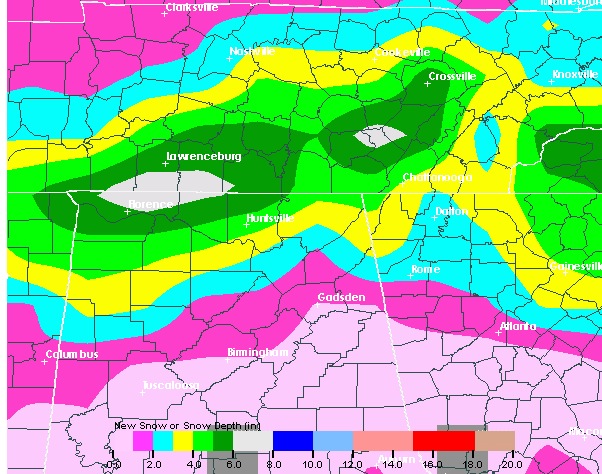
This is the NOAA Global Forecast System model (GFS). Heavy snow north of Huntsville and Atlanta.
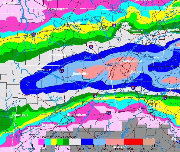
The higher resolution (NAM-WRF) NOAA model has heavier snow, and it's further south. I am leaning toward this one with a compromise to lower amounts of the GFS.
Either way, a lot of kids are not going to school tomorrow! I will produce and post a graphic (if time allows) of where I think we will see the heavy snow band set up. Look for it later this evening.
Snow pics later unless I have a huge busted forecast. I don’t even want to think about that!
 Dan Satterfield has worked as an on air meteorologist for 32 years in Oklahoma, Florida and Alabama. Forecasting weather is Dan's job, but all of Earth Science is his passion. This journal is where Dan writes about things he has too little time for on air. Dan blogs about peer-reviewed Earth science for Junior High level audiences and up.
[…] This post was mentioned on Twitter by Am Geophysical Union. Am Geophysical Union said: Dan's Wild Wild Science Journal: Deep South Snow http://bit.ly/fWgAhx […]