6 August 2010
La Nina is Brewing – It May Be A Strong One
Posted by Dan Satterfield
One of the reasons for the forecasts of a an active hurricane season is the predictions that La Nina would develop this summer. Remember that La Nina is an ocean circulation phase that brings unusually cold water to the surface of the Tropical Pacific.

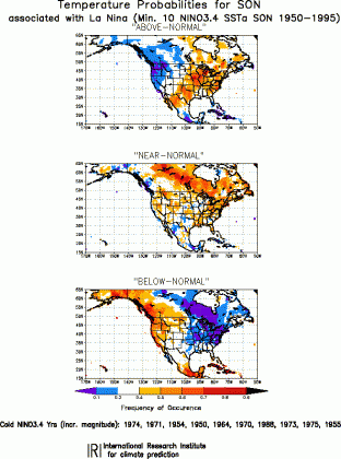
These are the temperature probabilities for a normal/above/below normal autumn (September through Novermber). Click for full resolution image.
Well, it has started and most of the ocean atmosphere models are predicting a moderate to strong event.
This has more impact than just the number of hurricanes. NOAA revised their 2010 hurricane prediction down somewhat today but they are still predicting a 70% chance of 4-6 major hurricanes (Earlier typo said 406- that would be exceptionally bad 😉 ). La Nina is a big factor in that.
The colder tropical waters cause a shift in the jet stream. This makes it possible to make a decent prediction of the fall and winter ahead. Here in the Southeastern USA we tend to have a dry fall with normal to above normal temps. The winter tends to be drier than normal and sometimes a bit on the mild side.
What about where you live?
The chart at the right shows the probabilities for temperatures during a La Nina event. The image is for the period from September through November.
Take a look at the Northeast USA and Eastern Canada. The chart shows that during a La Nina year the odds are VERY low that the autumn will be below normal. The odds are higher that it will be near normal and the odds are higher still that it will be a warm autumn.
This does not mean that it will not be colder than normal. It just means that in the past this happened rarely.
You can see more of these graphics for your part of the world at the IRI website here. Precipitation maps are also available.


 Dan Satterfield has worked as an on air meteorologist for 32 years in Oklahoma, Florida and Alabama. Forecasting weather is Dan's job, but all of Earth Science is his passion. This journal is where Dan writes about things he has too little time for on air. Dan blogs about peer-reviewed Earth science for Junior High level audiences and up.
Dan-typo in paragraph 3 Reads “406 major hurricanes.”
Thanks! Corrected- that should be 4-6 of course.