
4 July 2009
A Picture Worth a Million Dollars (and it cost about that much too!)
Posted by Dan Satterfield
To me the most fascinating part of synoptic forecasting is Satellite Meteorology. I can still remember working in Tulsa at KJRH TV where we had a GOES Unifax machine. Every 15 minutes a high resolution image would spit out. During the day the resolution was 1 km on a visible image. This was good enough to see jet contrails at times.
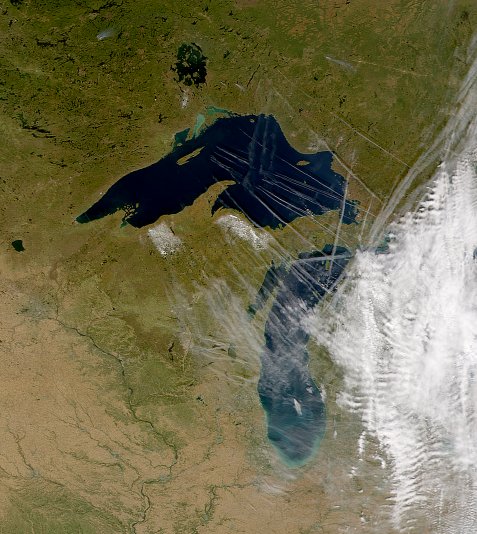
Jet Contrails from the NASA Modis Satellite- It sees true colour. GOES does not. These contrails keep the nights warmer and days slightly cooler over much of America.
One afternoon a large contrail was visible across Northeast Oklahoma and I ran outside the station and there it was! I was looking at the bottom of it, the satellite was seeing the top from 36,000km away. This seems like no big deal now, but in 1978, it was a very big deal!
TV viewers have since grown very accustomed to seeing satellite images on TV weather reports and now even online. What the average person does not know is just how incredibly valuable these images are.
It was once said that if the GOES Satellites could see nothing but hurricanes in the ocean, they would be worth 100 times the money spent to build them and put them in orbit. I certainly agree.
They do however see MUCH more than just hurricanes. Read on learn some of the incredible ways these satellites are making accurate forecasts and early severe weather warnings possible.
First some misconceptions.
1. Satellite images are not in colour. TV Weather graphic equipment remaps the cloud images over colour maps. The next generation of weather satellites GOES R will be able to see almost true colour. It is really not that necessary to forecasting anyhow.
2. These satellites are VERY high. About 1/10th the way to the moon. The reason is that at 36k km they orbit the earth once a day, and since the Earth turns once a day, they appear to hover over the same spot. If one breaks, the Space Shuttle cannot even get one tenth of the way up to fix them.
3. They are called GOES for Geostationary Operational Environmental Satellite. We use two if them in the USA. Goes East and GOES West. They are in orbit over the Equator and cannot see well in the high latitudes because of the curve of the Earth. Alaska, and Northern Canada forecasters use the Polar Orbiting satellites, but only get a few pics a day. The current operational east satellite is GOES 12. GOES 13 and 14 are in orbit, but in storage until needed.
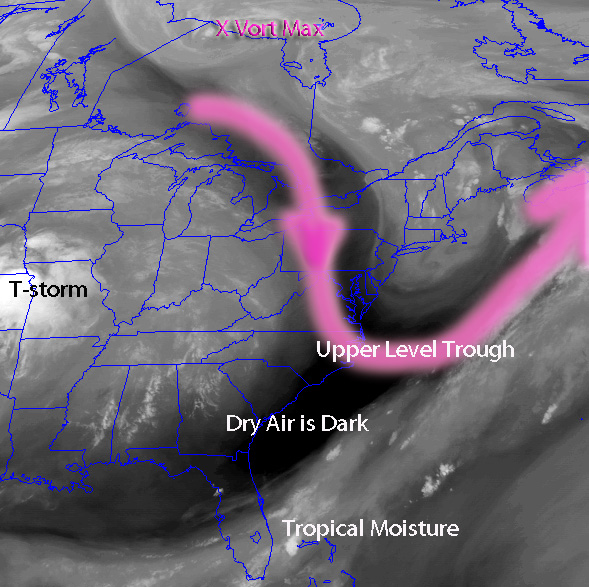
GOES Water Vapor IR imagery Image from July 4 05Z
4. They take mages every 15 minutes and can do an image over a small area every 7 minutes in rapid scan mode.
5. They do not have cameras per say. They have sensors that detect electromagnetic radiation. The visible light that your camera records when you take a picture is electromagnetic radiation. It’s light in the visible part of the spectrum.
X-rays and the radio waves from your favourite FM station are “light” as well. We humans just cannot see that light. So is infra-red radiation that “night goggles” use. You can buy video cameras now that see in the IR wavelengths.
The GOES imaging sensors actually see electromagnetic radiation in 5 different bands. One visible and 4 in the infra red. The GOES also has another sensor called the sounding radiometer. The sounder imager can actually detect temperatures and moisture at different levels in the atmosphere. Even under clear skies.
We can actually take a sounding without launching a weather balloon. (They cost you the tax payer about 100$ a pop too)
Even in daytime we get both the IR and visible images. At night we only get the IR of course. The visible channel can resolve objects bigger than about 1 km square. The IR imager is 4 km. One image you see rarely on TV is the Water Vapor IR images. These images look almost like an atmospheric X-ray and are very valuable to forecasters like me.
IR Image from GOES East Midnight 4 July 2009. See the storms in Kansas!
Using water vapor imagery we can see the outlines of troughs and even upper level low pressure centers called vorticity maximums. These “vort maxes” can kick off convection or intensify a low pressure system. Skies may clear suddenly behind them. Knowing their position also allows us to compare the real world with a forecast model. If the model has forecasted it well,then confidence in the models forecast is increased!
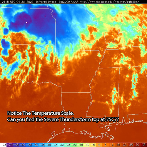
Since the amount of radiation an object gives off is related to it’s temperature, the IR images also can tell us the height of clouds and thunderstorms! The colder the cloud, the higher it is! High ice crystal cirrus clouds show up bright white on IR images, where ground fog is sometimes hard to see since it’s the same temp. as the ground.
A new technique has been developed that subtracts one channel from another and makes it possible to see fog at night. We call it the “fog Product“. High clouds over a fog layer will usually keep it from dissipating as fast so seeing the different layers of clouds is very important.
Lines of building cumulus clouds can be seen long before radar echoes show up. Many times when the atmosphere is unstable, these building towers are the first clue that severe convection is imminent and a tornado watch may be issued.
Geostationary weather satellites are over Europe and Asia, along with the Middle East, So we can actually see every corner of the globe. Not the high latitudes though, we only get images of the poles a few times a day. Forecasters in these high latitudes get very good at interpreting the lower and higher resolution images from the polar orbiting satellites. If you have the money, you can download the images from these satellites as they pass overhead. Lots of people do it!
Temperature structure of the atmosphere near Huntsville AL. From GOES. Numbers on the right are indexes that tell the forecaster about instability etc.
There are other sensors on these satellites as well. If you crash in a remote island, your plane will have an ELT on it. This Emergency Locating Transmitter will be picked up by the GOES. Detection of solar storms is also made possible by GOES along with other satellites. Arctic Ice in shipping lanes is also monitored with GOES. If there were GOES in 1912, maybe the Titanic would have missed that berg.
Yes, it cost a lot of money to put these satellites up in space and even more to build them, however the images they provide are very nearly priceless.
 Dan Satterfield has worked as an on air meteorologist for 32 years in Oklahoma, Florida and Alabama. Forecasting weather is Dan's job, but all of Earth Science is his passion. This journal is where Dan writes about things he has too little time for on air. Dan blogs about peer-reviewed Earth science for Junior High level audiences and up.
I was doing research on the IR image, and what it tells me as a pilot, and I came across this site. There aren’t enough sites with good info. that a pilot can use to understand weather. I have a question regarding the IR image. Is the image that I see showing clouds, or just the temp. of the air? If it’s clouds and the air is very cold the only way it could get that cold is by cooling adiabatically, and that would mean highly unstable air and storms. Is this correct?
IR pictures are showing nothing but temperature Chris. Cold clouds can e interpreted as very high clouds. Cold temps on a thunderstorm would indicate the top is quite high. I wouldnot go as far as to say you can always assume that a cold cloud was pushed up there by convection though. High cirrus clouds will form at very high and cold levels but are not a threat.
Also keep in mind that on a night like tonight with very cold air over the lower 48 states, IR images will show snow on the ground as a cloud because the temperature is as low or lower than mid level clouds are usually. So interpret the image with caution and with the known weather in mind.
A good place to get some additional training on weather is from the COMET program. http://www.meted.comet.ucar.edu
It is mainly for operational forecasters but there are several modules that you would find helpful I think.
Dan