
6 May 2009
Reporting Severe Weather- Do's and Dont's
Posted by Dan Satterfield
This has certainly turned into a Spring to remember here in the Southeast corner of North America. North Alabama in particular has been hit by storm after storm, with over 11 inches of rain falling in parts of the Huntsville area since May first. I am writing this on the 6th!
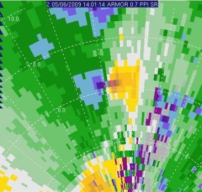
Data from ARMOR radar showing EF2 tornado this morning in Madison AL. Blue is wind toward the radar. Yellow is wind away from radar. The radar is at the bottom of the image.
Small tornadoes like EF0 and EF1 (EF means Enhanced Fujita Scale) are very difficult to see on radar, so the warning time is usually short. Nowcasting a severe weather outbreak can be very stressful when these are the type of storms expected. This morning, yet another tornado hit North Alabama. This one was on the ground for nearly 18 km, and did considerable damage with winds of 1oo knots. The width of the path was around 75 Meters.
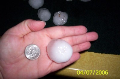
I know what golf ball size hail means!
The advent of digital cameras, and email has brought a whole new dimension to severe weather nowcasting. Meteorologists who work in TV, and for NOAA, often get emails with valuable information and pictures during severe weather. I have been thinking for awhile about writing about what we find very helpful and what we usually filter out. I have some examples of images too.
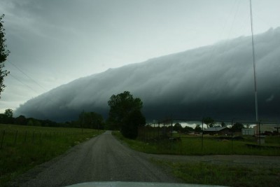
A scary looking Shelf Cloud is commonly mistaken for a "funnel". They do bring high winds though.
First of all, what we need.
1. Email reports of any hail and use coin sizes to describe it. Nickel, quarter, looney, two-ney (Canada) and a “Pound coin” (UK).
You get the idea.
DON’T use the words “marble size”. I don’t know how big your marbles are. You may have lost them for all I know! I know I lost mine a long time back!
2. Wind damage that is greater than small limbs down.
3. Significant structural damage, and be specific. This helps us estimate wind speeds.
4. Tornado clearly visible.
5. Well developed shelf cloud, if you are certain of what you are seeing.
What we tend to filter out:
1. Funnel cloud. Meaningless and useless, unless it comes from a trained spotter.
2. Wall cloud. Again, this is useless unless it is from a trained ham spotter. A wall cloud is the parent cloud of a tornado and develops in the rain free part of the storm. It usually exhibits rotation, and will hold it’s shape for longer than 10 minutes. TV programs on the Weather Channel, Weather Network (CANADA), also the Discovery Channel, have caused the public to see wall clouds everywhere when a tornado warning is issued. Only a small percentage of the wall cloud pictures I am sent are really of wall clouds.
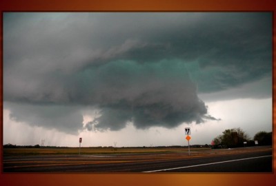
Wall Cloud near Florence Al. 2007.
Occasionally, a viewer will send me a pic of one, and ask what it is. I realize that they had no idea they were in danger.
There are some excellent resources on the web that will show you what a wall cloud, and a shelf cloud looks like. I always tell people, that if you see a real wall cloud, it will look EXACTLY like the pictures. IF you would like to know more about spotting severe weather, this slide set from NOAA is a good start. Another good page is here.
 Dan Satterfield has worked as an on air meteorologist for 32 years in Oklahoma, Florida and Alabama. Forecasting weather is Dan's job, but all of Earth Science is his passion. This journal is where Dan writes about things he has too little time for on air. Dan blogs about peer-reviewed Earth science for Junior High level audiences and up.
The picture of the wall cloud near Florence…..omg that would scare me to death. Why is it a greenish blue color in the middle? Looks like the ocean 🙂
That wall cloud would also scare me to death! I would be reporting it to the EMA and then asking where the nearest public shelter was (if I was out and about). I went through SKYWARN training last year with Tim Troutman and Brian Peters . . . and this year with some new guy at the NWS Huntsville . . . and so far I haven’t seen a wall or shelf cloud in person. Worst I’ve seen is some flash flooding and some pea-sized hail. LOL on the marble comment . . .
Wish more people were aware of the opportunity for SKYWARN training – the classes are free(!) and are a lot of fun if you’re into weather – I even got my Dad to go with me to one (he sleeps through tornado warnings, so that should give you an idea of his level of interest)- and he actually enjoyed it very much!