
12 April 2009
Twisters and Ice From The Sky
Posted by Dan Satterfield
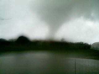
Good Friday 2009 will long be remembered in Alabama and Tennessee. Huge hailstones, and violent tornadoes pounded the region. Only two deaths, and some 50 injuries, but a lot of destruction. It certainly could have been worse, and to families that lost loved ones and homes, it is a tragedy that will be remembered for a life time.
Many times, when severe storms hit, the only view of hail or tornadoes for most people, is on TV. Not this time. The news room was inundated with calls from viewers, watching large hail stones dent their car, and ruin their roofs. Local car dealers here have over 300 damaged cars.
Modern technology is still not good enough to give reliable advance warning of small EF 0 and EF 1 tornadoes. (For those reading from other countries, the U.S. rates tornadoes on the Enhanced Fujita scale. This scale runs from zero to five. Five is very bad.) The large killer tornadoes are forecasted much better now than in the past. I warned viewers Thursday night that we faced such a threat, and showed on a map, where the threat was highest. We made the warning the lead story in our newscast. This kind of detailed forecast was impossible 25 years ago. Science has learned a lot.
Everyone in the path of the tornadoes had several minutes of warning Friday. I would like to think that this explains the low numbers of deaths, and injuries.
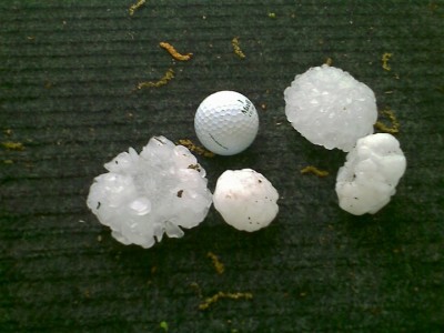
Looks like "Cricket ball" size to me.
We have had hundreds of images of the hail and the storms, along with a bunch of questions about the event directed to the Meteorologist. Since that’s me, I spent the day refreshing my memory on the science of hail, and wind. What follows are some answers. I have also written to one of the top experts in the field of hail research, so another post is possible soon.
A lot of the hail on Friday was the size of golf balls, but many reports of tennis ball, and even softball sized hail were reported. Viewers sent me pictures to back up the reports. They sent a LOT of pictures. These images allowed forecasters like me to better predict the size of the hail, in areas further East.
The super-cell storms are constantly being measured, as the tracked across Alabama and Tennessee. One of these measurements is called VIL. It stands for Vertically Integrated Liquid. The VIL is an estimate of the total liquid water in column through the storm.
If you divide the VIL of a storm, by the height of the storm, you get a number called the VIL density. This number tends to be a good measure of hail size. It’s not perfect, and there are other factors that can affect how large the hailstones that reach the ground are. One number we look at is called the “Wet Bulb Zero” height. It tells us how close to the ground the hail stones will start to melt. Detailed info on VIL, and VIL density is available for my fellow nerds here.
When viewers start sending me pictures of golf ball sized hail, and I know the storm has a VIL density of say 4, then I can be quite certain that other storms that day with a vil density of 4 will have larger than golf ball sized hail. These images are very helpful indeed, but I worry that people will get hurt in their attempt to take photos of the hail. There was an injury Friday. A woman was hit in the head with a large hail stone, while running to a car, to get out of the storm.
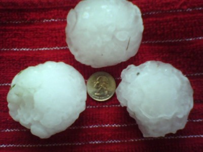
Coins are a good way of communicating hail size. avoid using the term "marble size". I don't know how big your marbles are! You may have even lost them!
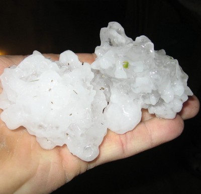
Some of the hail was clear ice, instead of opaque. This clear ice is likely related to the freezing rate, and the amount of supercooled water in the highest reaches of the super-cell thunderstorm. Slower freezing, and slower hail growth, gives clear ice. The amount of supercooled water around the hail stone seems to play a big roll in the determination of clear vs. opaque.
Another viewer asked about the jagged hailstones. These are likely hail stones that are made up of several chunks of ice that froze together. A large stone like this, can only be thrown upward, and held aloft, by an updraft of around 160 km/hr! Stones this size are rarely seen and when they are, a violent tornado is usually close by. The exception is Colorado, where stones this large can form with no tornado. So, that rule is mainly for areas East of the High Plains.
The Hail Friday was Quite Varied In Shape/Size
Several images of hail that was “egg” shaped were sent in. I am not certain how this happens. It may very well be related to the intense low pressure circulation inside the tornadic thunderstorm. Centrifugal force perhaps? You can read more about hail on the UCAR Fact Sheet.
Meteorologists call this the mesocyclone, and Doppler weather radars can detect the strength of the mesocyclone. The mesocyclone near the largest hail on Friday was very intense. So intense, that I was quite certain, a tornado was on the ground, and doing damage. Storms like these we tracked on radar Friday, are seen rarely. In my 30 years of forecasting, I have tracked storms like that on maybe 6 or 7 days.
Wall clouds are very popular with the public. Storm spotter courses show lots of pictures of them, and when we have strong storms, I get many photos from viewers of what looks to them like a wall cloud. I always tell our reporters in the field, that a wall cloud will look just like a wall cloud. If there is doubt, it probably is not one. Wall clouds are the parent cloud of a tornado, and a rotating wall cloud is a sign that you may be about to see a tornado. Best not be in a location ahead of one!

Wall clouds will form under the "rain free base" of a supercell.
Sometimes a pendant will slope down, from the wall cloud toward the rain shaft. This is called a tail cloud. Usually, rotation in the wall cloud is quite apparent.
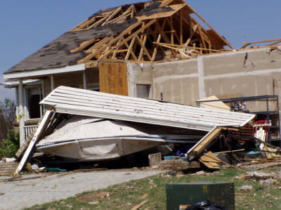
The tornado that tracked through Marshall, Dekalb, and Jackson counties on Friday has been rated as an EF-3 on the enhanced Fujta scale. This means winds of over 150 mph. The maximum width of the path of damage is nearly 1KM!
The estimate of the tornado’s size, and strength is based on several factors, The width of the path, and it’s length. The maximum winds can be estimated by the damage to trees, and structures. It is important to realize that if a large tornado does no damage, then it cannot be given a rating.
Many times, people will insist that a tornado has been under rated because there are many destroyed homes. If these homes are mobile homes/trailers, then an EF2 tornado will completely destroy them. If there is no major damage to wooden homes, then the tornado rating is likely correct. An EF2 will also usually destroy a garage or out buildings as well.
The EF3 tornado is much stronger, and does much more damage to wooden/ brick structures, on a foundation. An EF2 tornado has winds up to 115 knots or round 219 km/hr. An EF3 has winds from 219- 265 km/hr. That is nearly 160 knots. A category 5 hurricane is another example.
Typical EF3 Damage (From NOAA-NWS)
Heavy cars will be thrown a good distance by an EF3 and walls of well built structures will collapse. Damage in the Sylvania area, of Dekalb County, indicates that the tornado Friday was at EF3 strength. Late word from the NWS survey team tonight, of one home that was picked up, and slammed 4 feet into the dirt in Sylvania. Read the preliminary storm survey here.
The methods of rating a tornado is explained in this slide show. If everyone who lived in a mobile home, left for safer shelter during a tornado watch, the death toll from tornadoes would drop by half in this country. Don’t think that tie downs make any difference. They almost certainly do not.
Thanks to all of our viewers here in Alabama and Tennessee whose pictures and reports helped us track the storms on Friday. If you see your picture in this post-please email me and I will add a credit. We have so many- the names have been separated!
UPDATE SUNDAY EVENING: Donnie Charles of Albertville emailed us this picture. It’s a GIANT wall cloud. Taken in 2006, but a good example.
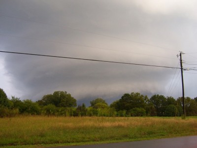
Huge Wall Cloud Near Albertville, Al 2006.
Notice the striations. Wall clouds like that almost always accompany killer tornadoes.
Now the bad news. More storms Monday.
Keep safe,
Dan
 Dan Satterfield has worked as an on air meteorologist for 32 years in Oklahoma, Florida and Alabama. Forecasting weather is Dan's job, but all of Earth Science is his passion. This journal is where Dan writes about things he has too little time for on air. Dan blogs about peer-reviewed Earth science for Junior High level audiences and up.
Won’t burden you with a long comment . . . so much that I could say . . . but I guess I’ll just say thank you for the best severe weather coverage humanly possible during such a crazy event that although the signs were there ahead of time, still felt like it “exploded” really fast once it got underway.
Keep up the good work! I enjoy reading your posts.