
October 16, 2015
Making a Path for Geologic Maps
Posted by elandau
Today’s focus for Earth Science Week is Geologic Map Day. The goal of the day is to highlight the importance of maps and how they contribute to improving our quality of life on a daily basis. Maps have more uses than getting us from point A to point B; they are applied to tracking the spread of diseases and monitoring migration patterns, both producing significant public health and safety benefits. And that’s just to name a couple of examples.
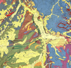
Image credit: USGS
Maps are also necessary tools for Earth scientists, engineers, and others as they continue to explore above and below the Earth’s surface, improve our understanding of how the Earth works, and determine what causes some natural disasters. Two programs, Earthscope and US Array, sponsored by the National Science Foundation (NSF), U.S. Geological Survey (USGS), National Aeronautics and Space Administration (NASA), Department of Energy (DOE), and state geological surveys are furthering these efforts. Earthscope provides funding for new, innovative projects seeking to explore the Earth in original ways, with focuses on deep Earth structure, faults, crustal strain, and earthquakes. One such project is US Array, which implements seismic stations across the country for scientists to explore seismic waves and resulting natural hazards. A denser seismic network provides necessary data to find correlations between activity below the surface and resulting natural disasters.
The public safety benefits of geologic maps are vast, from a better understanding of potential for natural hazards to better-informed decisions about how to prepare our cities for potential hazards. Natural disasters like earthquakes, volcanic eruptions, and landslides affect the entire nation. While not always possible, significant warning times are often necessary for communities to safely withstand natural disasters. Providing warning is much more difficult without projects like Earthscope and the US Array.
Earthscope and US Array serve important purposes and improve our ability to prepare for and survive natural disasters. Unfortunately these programs are at risk, as funding for basic Earth science research is threatened in the current appropriations process. The FY2016 House budget for NASA’s Earth science programs is five percent less than FY2015, and the Geoscience Directorate of NSF is deprioritized in the House version of the America COMPETES Reauthorization Act of 2015. Such cuts hinder exploration of our Earth and devalue the Earth sciences, setting a dangerous precedent. Earth sciences inform decisions related to weather forecasting, renewable energy development, and natural disaster preparedness. Without data to support such decisions, communities are increasingly put in danger of natural disasters and policy makers are unable to make reliable, forward-thinking decisions.
Geologic Map Day showcases the benefits mapping brings to our nation and the need for future efforts to map both on and below the Earth’s surface. If you are concerned about the lack of funding for the Earth sciences please tweet at your legislators using #MapDay, #ScienceIsEssential, and #EarthSciWeek. You can also visit AGU’s Policy Action Center to learn about how to write your congressional delegation and support science funding.