
14 March 2018
New media to show off exemplary features of the Devonian-aged Hampshire Formation along Corridor H, West Virginia
Posted by Callan Bentley
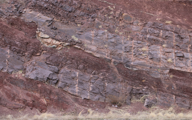
Last week, I was in Morgantown, West Virginia, to deliver a colloquium talk to the geology department at West Virginia University of geological visualization. The next day, I took some time on the way home to geologize a bit on the road called Corridor H, a gorgeous transect through the eastern Allegheny Plateau and western Valley & Ridge provinces. I focused that day on the Hampshire Formation, Foreknobs Formation, and Tonoloway Formation. Among these, the Hampshire is the most recent. It’s a series of river channel sandstones and their associated floodplain muds. It is bright red in color, indicating its deposition under highly oxidizing conditions; it’s a classic set of “red beds.”
Many of the roadcuts on Corridor H show insightful cross-sectional views of some of these channels:
Here’s a GigaPan I made there (viewed through the lens of the superlative GIGAmacro imagery viewer):
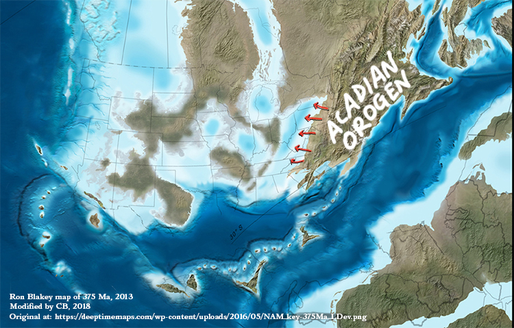
These sandstones and red shales used to be sand and mud back in the Devonian period of geologic time. That sand and mud didn’t magically spring into existence, materializing from thin air. Instead, it materialized from a thick mountain range. This was the time of the Acadian Orogeny, a mountain-building event accompanying the accretion of a microcontinent. In this modification of one of Ron Blakey’s excellent paleogeographic maps, I show with red arrows the sediment transport that would have transpired as the Hampshire Formation was being deposited:
 Click for original source image by Ron Blakey

It’s “molasse,” the terrestrial siliciclastic signature of an orogeny.
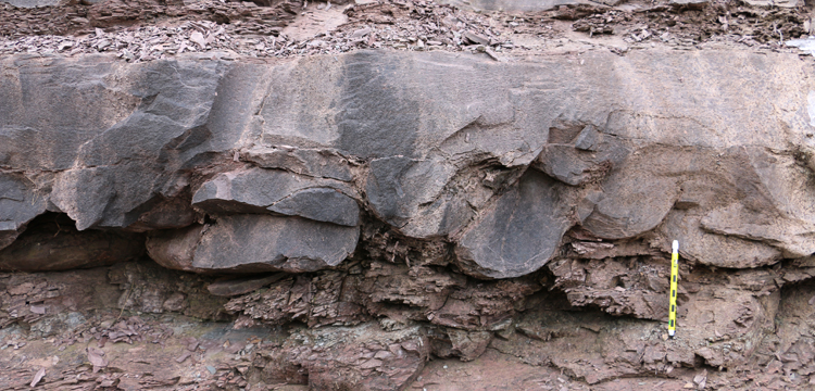
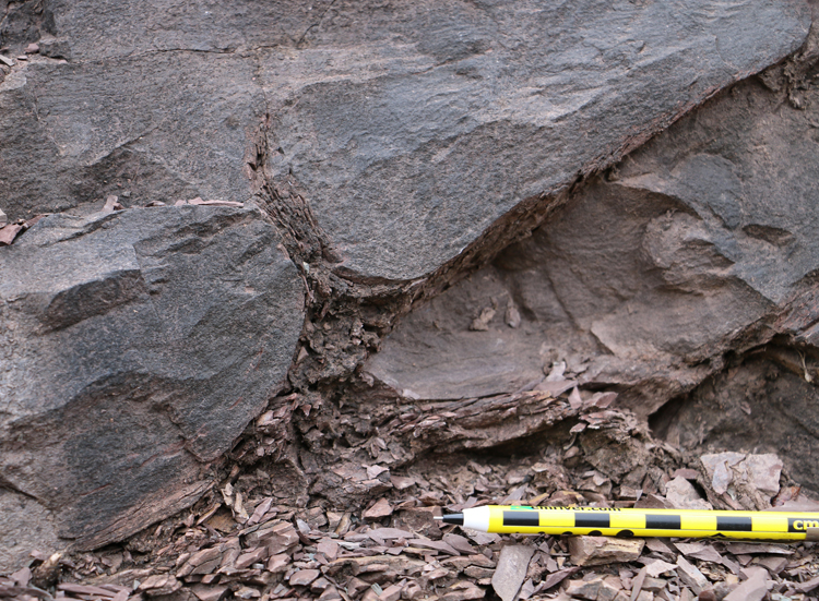
The Hampshire has some truly excellent primary sedimentary structures that were formed during the time its sediments were deposited. For example, check out these “ball & pillow” loading structures, as a heavy load of wet sand was suddenly laid down on top of some squishy wet mud. The sand sagged down, and the mud squirted up between lobes of descending sand, making flame structures.
Here’s a 3D model of it:
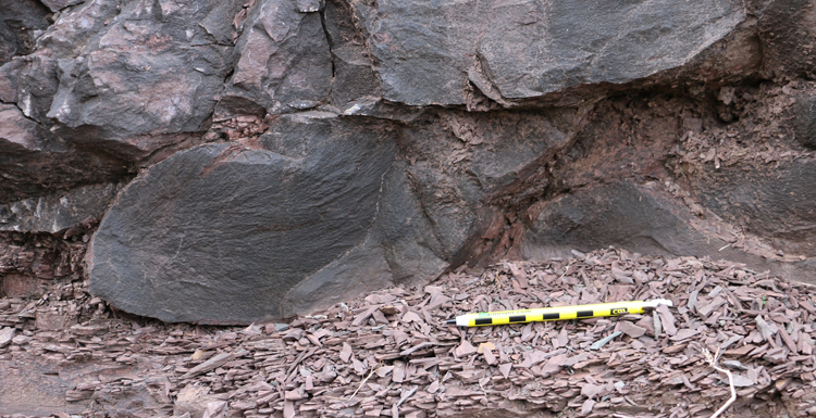
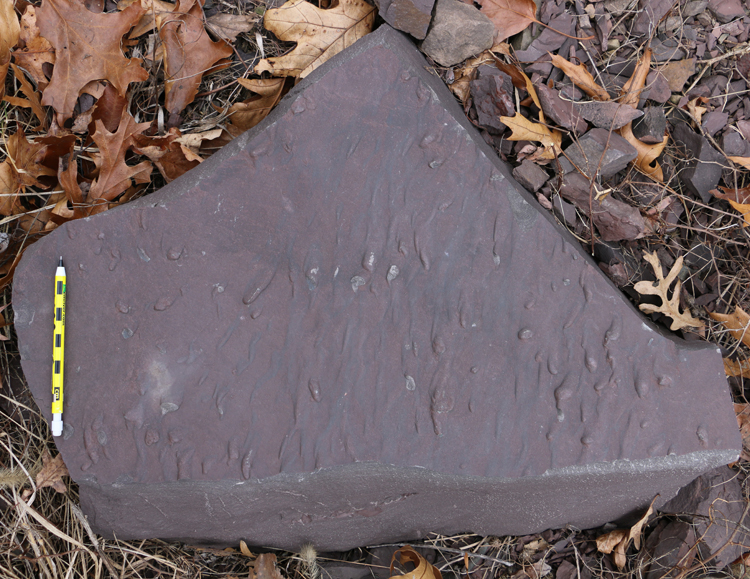
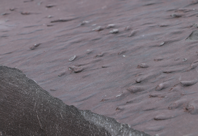
I also found this excellent example of a congruent primary sedimentary structure. This slab (upside-down) shows flute casts, the sand-filled-in declivities excavated by scouring currents into an underlying (pre-existing) mud deposit. This hollowed out tongue-shaped grooves, deepest upstream and then flaring out and shallowing in the downstream direction. After the scouring was completed, sand came in and filled in the hollows.
Looking obliquely across the downstream (to the right) current:
Here is a 3D model I made of this slab:
The Hampshire is a favorite of mine on Corridor H. It tells a beautiful, consistent tale, one with big-picture tectonic importance, but also one accentuated with fine details.
 Callan Bentley is Associate Professor of Geology at Piedmont Virginia Community College in Charlottesville, Virginia. He is a Fellow of the Geological Society of America. For his work on this blog, the National Association of Geoscience Teachers recognized him with the James Shea Award. He has also won the Outstanding Faculty Award from the State Council on Higher Education in Virginia, and the Biggs Award for Excellence in Geoscience Teaching from the Geoscience Education Division of the Geological Society of America. In previous years, Callan served as a contributing editor at EARTH magazine, President of the Geological Society of Washington and President the Geo2YC division of NAGT.
Mile marker?
Hi Sam,
Multiple sites – which one do you want to visit?
Greetings from Winchester, VA
Could you help me with properly identifying the various sedimentary rock formations
and fossils contained within the Foreknobs Formation out here in the Shenandoah Valley.
Any assistance would be greatly appreciated.
Mark
Hi Mark,
I reckon I could if you post photos somewhere, but such armchair geologizing is subject to a fair amount of baked-in uncertainty.
CB