
8 February 2018
A spectacular display of Earth science in the Alabama Hills
Posted by Callan Bentley
My friend Barbara am Ende posted this image on Facebook the other day, and I instantly swooned over its myriad teeming geoscience lessons. Gaze upon its majesty, ye mortals, and rejoice:

Click through to enlarge. The photo is copyright Barbara A. am Ende.
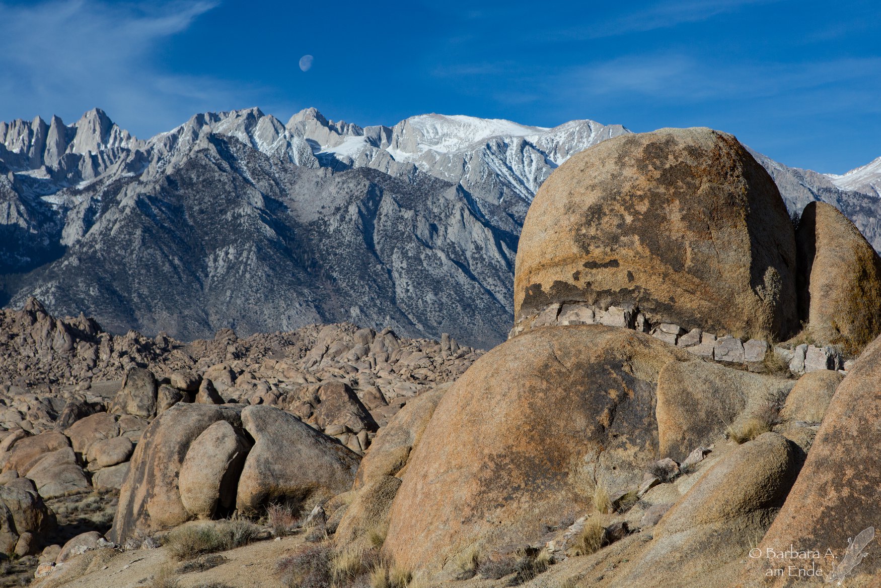
 This image shows the Alabama Hills outside of Lone Pine, California, in the Owens Valley, looking west at the eastern slopes of the Sierra Nevada mountain range. What do you see here?
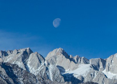
Let’s start with the biggest picture: this photo shows a portion of our planet, Earth. But we are not alone: looking up into the space adjacent to our planet, we can make out a moon. The blue of our atmosphere surrounds that lovely orb, approximately 2/3 lit. We note that the orientation of the shadow of the moon is identical to the shadows we see on the rock outcrops in the foreground. The sun is off to the left, to the south. This is in the northern hemisphere; we’re looking westward. It appears to be late morning or mid-day, on the basis of east-facing slopes being well lit and not in shadow. So I reckon that gibbous moon is waning. Though it’s far, far away, the moon is sufficiently lit that we can distinguish between its older anorthositic highlands and its lower, younger basaltic “maria” (lava flows filling impact craters). We have a view here into another world.
 Next up, let’s look at the more Earthy subjects: the mountains and the foreground. The two are separated by the Sierra Nevada Frontal Fault, which is the first of the Basin and Range normal faults headed east from the Pacific Coast, and the dividing line between the Sierra Nevada and the Basin and Range. The many north-south-trending faults of the Basin and Range are due to the singular tectonics of the western United States. For the past 30 million years, the west has been widened, the tectonic stresses imposed by the plate boundary to the west being taken up not only by the San Andreas Fault, but also to a lesser degree (~15%) by deformation a good distance into the continent. This oblique shear (transtension) has caused the rocks between the eastern Sierra and the Wasatch Front to have been stretched most profoundly from east to west. At the surface, this deformation is taken up along normal faults, with the hanging wall dropping down to make Basins, and the footwall left high and dry as a Range. The local example is the Sierra Nevada Frontal Fault, the one we gaze across in this image. The rocks on both sides of the fault are Cretaceous granites -the crystallized results of multiple silica-rich magmatic intrusions into the edge of the North American crust during a protracted period of subduction during the Mesozoic. They are the roots, the plumbing, of a continental volcanic arc akin to that operating in the modern day in the Andes.
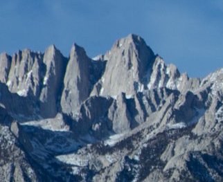
But in spite of their common lithologic identity, the granites on either side of the fault look strikingly different. Up high on the Sierra crest, peaks like Mount Whitney (the chunky peak at left, adjacent to the two spiky Keeler Needles) poke up to more than 14,000 feet above sea level. They are subjected to radically different weathering conditions than the Alabama Hills (at only ~5300 feet of elevation). There’s almost 10,000 feet of vertical difference between Mount Whitney’s granite and that of the Alabama Hills.
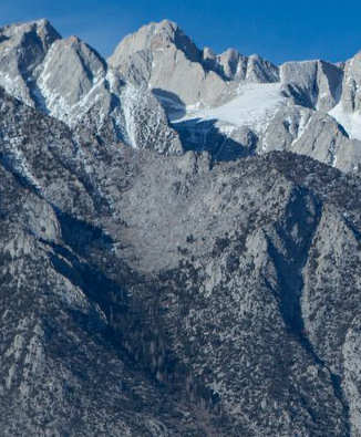 Up high, it’s cold. The high Sierra has been glaciated, and even retains some permanent icefields and “glaciers” to this day. Some of the valleys draining to the east have a wide, U-shaped profile at their tops, and transition to narrower, V-shaped profiles downslope. During the Pleistocene epoch, the “Ice Age,” the Sierras were swathed in glaciers, with ice flowing downhill under its own weight, plucking and abrading and gouging thereby into the tough rock from which the mountain was made. This glacial erosion hewed the mountain range into a new shape, a sequence of peaks separated by valleys, like the teeth on a saw. The name “Sierra” reflects this – it is Spanish for “saw.” The cornucopia-like shape of the valleys we can see speaks plainly about the changing stability field of ice as elevation decreases. Clambering around in that transition zone, you’d doubtless find faceted erratics and striated bedrock. The fact that the Earth’s climate can shift between warmer and colder states is a fundamental insight of modern climate science. Do you like the temperature outside? “It’s a lovely climate you got here. It’d be a shame if something happened to it…”
Wisps of cloud in the sky remind us of the water cycle that dumped the glacier-forming snow on these mountains during the Pleistocene epoch. There are two tree-lines on the Sierras’ eastern front: an upper one defined by temperature (above which it’s too cold for trees to grow) and a lower one defined by aridity (below which it’s too dry for trees to grow). There’s a 10,000 foot difference between the bottom of the Owens Valley and the crest of the range that stands between it and Pacific moisture. It’s a perfect recipe for a rain shadow.
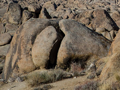 Down below, it’s warmer, but also in the rain shadow of the wall of mountains to the east. No glaciers at this elevation! Instead, thermal expansion and contraction coupled with exfoliation allows the Alabama Hills’ granite (technically, a biotite monzogranite) to weather into spheroidal forms. There’s a lot of grus about, as feldspars spall off and pile up in gritty piles. This grus is highly porous and permeable, and water tends to sift right through it. Notice how the few plants in this sere terrain either root in the cracks (joints) in the granite, or immediately adjacent to the impermeable outcrops: these are the only sites where water is likely to be retained long enough for a plant to be able to do something with it.
On the shadowed side of the rounded forms you can see a faint orange-colored tinge: probably lichens able to survive on the north side of the boulders, where shadows tend to retain moisture for a little extra while longer. These lichens, a symbiosis between fungus and algae, help aid in breaking down the granite as their hyphae probe microfractures and as they exude acids that enhance the chemical breakdown of the granite’s outer surface. Elsewhere, the Alabama Hills granite have a dark patina — this is desert varnish, an interesting combination of manganese and iron oxides, clays, and biofilm. It makes for good petroglyph opportunities. All told, the rough serrated Sierra in the background, and the worn-down-looking foreground make for good theater: Coupled with the Alabama Hills’ proximity to Hollywood, this place was the filming location for a number of movies, in particular westerns.
 Another thing we may notice is that there’s a beautiful aplite dike cutting semi-horizontally through the prominent knoblet of Alabama Hills granite in the right foreground. These fine-grained felsic dikes are common in the plutons of the Sierra Nevada batholith, and thanks to their clear cross-cutting relationship with the host granites, reveal themselves to be younger than the rocks into which they have intruded. It has a closely-spaced set of dike-orthogonal fractures cutting across it, giving it a blocky weathering pattern. These joints formed in the shortest possible direction to cut across the dike from one side to the other, and these fractures of course must post-date the dike. You can’t break something that doesn’t yet exist.
All told, there are many interesting features to be seen in this lovely, well-lit, well-composed image. The great depth of field, where the moon and the aplite dike are both in focus, allows us to explore geological features that extend over numerous scales, near and far.
What did I miss?
 Callan Bentley is Associate Professor of Geology at Piedmont Virginia Community College in Charlottesville, Virginia. He is a Fellow of the Geological Society of America. For his work on this blog, the National Association of Geoscience Teachers recognized him with the James Shea Award. He has also won the Outstanding Faculty Award from the State Council on Higher Education in Virginia, and the Biggs Award for Excellence in Geoscience Teaching from the Geoscience Education Division of the Geological Society of America. In previous years, Callan served as a contributing editor at EARTH magazine, President of the Geological Society of Washington and President the Geo2YC division of NAGT.
Very *thoroughly* explained, Callan! Despite having taken Lunar Geology (and yes the early scientists in the moon project made the decision to not call it lunology), I didn’t think about the geology there. I also took a closer-up shot of the grus with a small mound of monzogranite sticking up. But the two look so much alike, I’m not sure it’s that clear of a shot after all! I found it interesting (having lived far too long near Callan where granites weather to saprolite), that where the monzogranite that doesn’t have the desert varnish is very jagged (on a smallish scale) around those feldspars and painful to sit on with thin, wicking hiking pants.
I’m not especially familiar with this area, and I want to thank the USGS for having online geologic maps these days. When I got home from the trip, I was able to check up on some things like the age of the granites in the area and the presence of the fault that *had* to be there.
Nice description of the 2 tree lines. I didn’t think of it that way, but you’re right!
Thanks for sharing! I have spent some time north of Lone Pine rock climbing around Bishop. I was always amazed by the quality of the granite-like geology on the west side of the valley, and the completely different volcanic geology on the east side, but of equal quality. Climbers come from all over the world to climb in this area owing o he long season of perfect conditions for the sport. Some of the features in the Owen’s River Gorge are stunning – I must pull out my photos of the area and share!
Hopefully, Callan, you get to do a family (or geo) trip up CA Hwy 395 some time (or again?). It is always well worth it. A stop in Lone Pine, maybe overnight at the Dow Villa, is a nice break (or Bishop). Head on up Mt Whitney Portal road – wander around the Alabama Hills first – to a mini-Yosemite day-trip at the Whitney trailhead parking area (free!), and you are having a great day. So much to see and do, leisurely, too (or not), on 395. My vote for one of the “Great American Road Trips.”
I love 395. When I lived in Southern California, the Owens Valley was #1 on my list of fun places to spend the weekend.
Long ago my girlfriend and I camped in the Alabama Hills under a full moon, and I decided to walk to the base of the Sierras, because they looked so close. After an hour of hiking they hadn’t gotten any closer, so I turned around and headed back to camp.
🙂
Perhaps worth mentioning that the magnificence of the landscape in the Alabama Hills wasn’t lost on Hollywood: https://en.wikipedia.org/wiki/Alabama_Hills#Filming_location
I remember an early-1980s UCLA geology field trip that included the Alabama Hills; one night around the campfire we entertained ourselves by trying to recall all the films and TV programs and commercials that were done there.
The geology along 395 is amazing. Turn around 180 from that view and see the Inyos, and the Union Wash fossil site (ammonites, early Triassic).
That view displays the mountaineers route up Whitney, which Muir pioneered solo (and was the third ascent up the peak). Done that route twice myself.
The granites of Whitney and of the Alabama Hills are two different plumes though close in age. They are separated by yet another plume of slightly different granite.
Great details; thanks.
Yes, I’ve gone up Whitney that way, too. (Only once, though!)
By “plumes,” here, I’m assuming you mean plutons.
Thanks again!
C
Enjoyed your posting… Not obvious from the photo but worth mentioning is the active nature of the Owens valley, including the 1872 earthquake that left a clear surface scarp near Lone Pine. The scarp can be traced for almost 100 km.
Out of the frame but not too far away along the Whitney Portal road is an epic glacial till with rounded boulders of SNB hauled down from the heights. And one roadside outcrop there has a giant spray-painted fanged happy-face with an aplite dike cutting along its base. And then further up US 395 just south of Big Pine, on the north side of Crater Mountain (a relatively recent, small basalt-ish volcano) is a Native American cemetery with many elaborate and distinct markers right at the foot the volcano. Quite a place at sunset, but the whole Owens Valley is fantastic.