
16 September 2011
Turbidity in Chesapeake Bay
Posted by Callan Bentley
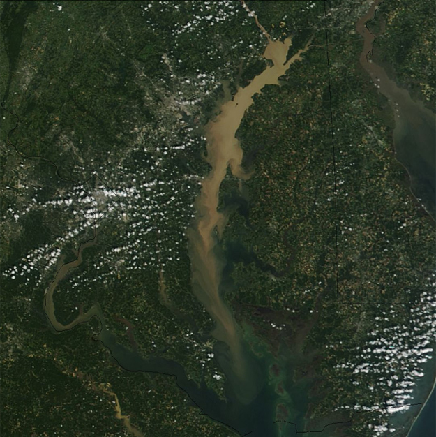
Hurricane Irene passed this way two weeks ago, and dumped a lot of rain on the mid-Atlantic region and the northeast. As a result, runoff increased, rivers swelled, and sediment was mobilized. Some of that sediment was suspended and transported downstream. On Tuesday, I got this e-mail from my colleague Ken Rasmussen, who took students out on an oceanography field trip to Chesapeake Bay a week after the storm:
Was out with students on bay on 9/11. Turbidity was amazing- more like chocolate milk. Lots of logs, trees, floating urban debris, etc. Mid-bay surface salinity remarkably low (less than 4 ppt; more typical is 16 ppt in Sept.). Thought you’d like to see this MD DNR satellite image and mid-bay surface photo, both attached. On the bright side- dead zone was mixed/disrupted.
NASA Earth Observatory published a better version of the satellite image than the MD DNR version, so I’ll reproduce a portion of it here:
Here’s Ken’s on-the-scene photograph:
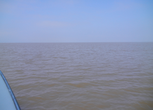
It seemed to have a bluish tinge to it, so I clicked “Auto Levels” in Photoshop, and got this result:
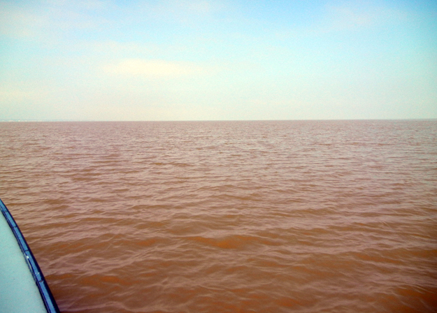
That’s a lot of suspended sediment!
Just thought I’d share this, with Ken’s permission, of course. It makes me think about the role of hurricanes and other infrequent events in the sedimentary record. The salinity change (due to the large influx of freshwater runoff) is interesting too. Does that have any effect on sedimentation rates? I’m thinking about charges on the surface of clay particles, and flocculation rates changing due to the decrease in ions in the seawater – just wondering aloud here. I know next to nothing about those sorts of geochemical/geophysical interactions. Chime in if you can enlighten me.
 Callan Bentley is Associate Professor of Geology at Piedmont Virginia Community College in Charlottesville, Virginia. He is a Fellow of the Geological Society of America. For his work on this blog, the National Association of Geoscience Teachers recognized him with the James Shea Award. He has also won the Outstanding Faculty Award from the State Council on Higher Education in Virginia, and the Biggs Award for Excellence in Geoscience Teaching from the Geoscience Education Division of the Geological Society of America. In previous years, Callan served as a contributing editor at EARTH magazine, President of the Geological Society of Washington and President the Geo2YC division of NAGT.
Juergen Schieber’s (Indiana) experiments on mud sedimentation indicate that salinity has very small effect on the degree to which clay particles flocculate (which, in turn, affect their settling rate).
If you have the inclination, I’d recommend Schieber et al.’s videos on YouTube summarizing their mud deposition experiments: http://www.youtube.com/watch?v=i-rnObaFrvE
Also, I’d have to dig up some references to find the numbers, but I remember being surprised how low the SSC (suspended sed concentration) is in some of these river-derived sediment plumes. Higher than ‘normal’ conditions obviously, but wasn’t as high as I would’ve thought.
We had a group of students out at Brownie Beach, Bayfront Park (just south of Chesapeake Beach) last Saturday: turbidity levels are still WAY up. Water looked somewhat less “chocolate milk” and more “really strong iced tea”, but still… Amount of debris at the strand line was the most I’ve seen there in fifteen years of repeated visits.
I wonder how/if the salinity change and influx of sediment is going to affect oyster cultivation. Don’t they spawn in around this time of year?