
27 September 2010
Deducing my first anticline
Posted by Callan Bentley
When I was done with my sophomore year at William & Mary, I embarked on a time-honored tradition among W&M geology majors: the Geology 310 Colorado Plateau field course. Jess alluded to this same course in her Magma Cum Laude contribution to this month’s Accretionary Wedge geology blog “carnival,” too.
My version of Geology 310 was led by the legendary Gerald Johnson (a.k.a. “Dr J”), a dynamic and enthusiastic educator who seemed particularly at home in the field. One day, he had us out in Utah (I think) somewhere, and pulled over to the side of the road so we could examine some tilted sandstone layers. We took a strike and dip reading, and plotted it on a map.
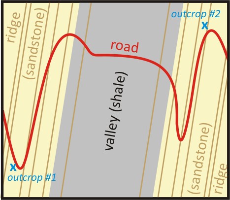
Then we descended into a narrow valley, where Dr. J did some “geology at 60 miles per hour,” pointing out shale outcrops in a few places in the valley. Then we drove up the opposite side. We pulled over again. Same sandstone strata: we again took a strike and a dip on the beds. The data was then recorded on our maps with a strike and dip symbol, a broad, squat “T” shape, where the upper bar of the “T” is parallel to the strike of the bedding, and the vertical prong of the “T” is pointing in the dip direction.

“Well,” Dr. J asked us, “What’s going on here?”
We were all silent, trying to puzzle it out. What’s the deal? What is he fishing for? Seconds ticked by, and no one had the right answer. We started to sweat… “Um, the sandstone beds are dipping to the west on the ridge west of the valley,” someone ventured, “and they are dipping to the east on the ridge east of the valley?”
“Yes, but what does that mean?” he replied. Silence…
Eventually, he relented, and spelled it out for us. Imagine this situation from the sides, he suggested, gesticulating the layers dipping off in opposite directions. “These are the same layers, so they were once laterally continuous…” He mimed a cross-sectional perspective:
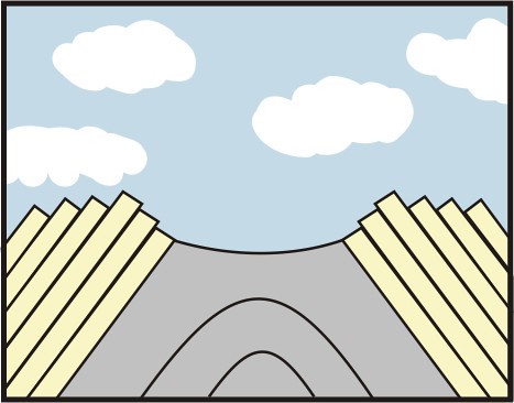
How could we connect these disparately oriented strata together?

Bam! It hit me: I got the idea of an anticline at that point — the idea that a structure like an anticline could be so large that I couldn’t actually see it from my earthbound human-sized perspective, and I could only infer it from detailed measurements of the rock structures. It was a revelation to me: this valley and its surrounding ridges were part of a massive fold. The anticline must have breached in the middle, with the shale eroding away faster than the sandstone, producing a valley flanked by two ridges.
I’m grateful to Dr. J for putting us through all stages of this exercise: collecting the incremental pieces of data, being forced to think about it in an attempt to come up with an interpretation, and then finally giving us the proper interpretation, once it had become obvious we weren’t going to get it on our own. This last bit is particularly important to me as an educator: sometimes it’s okay to spell it out for students, particularly if it’s their first time walking down a particular path. By revealing the “answer,” Dr. J guided my thinking from data to big picture structure to geomorphological interpretation in a way that I can only describe as “opening up a new pathway” in my mind. Once he showed the way to think about this sort of thing, it was suddenly very easy for me to visualize this sort of complicated four-dimensional story. Once the pathway was there, it was almost effortless to let my thoughts flow along that pathway. Weird how one’s perspective can change in a moment, and how that influences everything that comes after.
For me, this exercise and ensuing discussion constituted an important moment in developing my ability to think like a geologist. I don’t think my brain will ever be the same.
 Callan Bentley is Associate Professor of Geology at Piedmont Virginia Community College in Charlottesville, Virginia. He is a Fellow of the Geological Society of America. For his work on this blog, the National Association of Geoscience Teachers recognized him with the James Shea Award. He has also won the Outstanding Faculty Award from the State Council on Higher Education in Virginia, and the Biggs Award for Excellence in Geoscience Teaching from the Geoscience Education Division of the Geological Society of America. In previous years, Callan served as a contributing editor at EARTH magazine, President of the Geological Society of Washington and President the Geo2YC division of NAGT.
Indeed Callan you were in Utah when your brain was forever altered. I too experienced a similar sense of geologic clarity in the same spot as a student on the 1986 W&M Geology 310 trip when we traversed the Harrisburg anticline (between Zion National Park and St. George, Utah) with Dr. J.
Nowadays there is a race track in the core of the anticline and a golf course on its western limb, but the W&M Geology 310 trip continues to pay homage to this delightful structure and hopefully the geologic light bulb continues to get switched on by these well-exposed Mesozoic strata.
Cool. Good to know that others had the same experience at the same spot!
An addendum to Chuck’s comment — now that I know what it’s called, I was able to Google it!
So here’s a map showing the Harrisburg anticline. Check it out for yourself!
[…] trip or at field camp, as it did to rock stars such as Brian Romans, Geotripper, Tuff Cookie and Callan Bentley. One would imagine it transpired while I stared longingly into a microscope at those mesmerizingly […]
[…] trip or at field camp, as it did to rock stars such as Brian Romans, Geotripper, Tuff Cookie and Callan Bentley. One would imagine it transpired while I stared longingly into a microscope at those mesmerizingly […]
Awesome structure (and awesomer story)!