
30 March 2010
Sugarloaf
Posted by Callan Bentley
Sunday morning, NOVA adjunct geology instructor Chris Khourey and I went out to Sugarloaf Mountain, near Comus, Maryland, to poke around and assess the geology. Sugarloaf is so named because it’s “held up” by erosion-resistant quartzite. It’s often dubbed “the only mountain in the Piedmont,” which refers to the Piedmont physiographic province. Here’s a map, made with GeoMapApp and annotated by me, showing the general area:
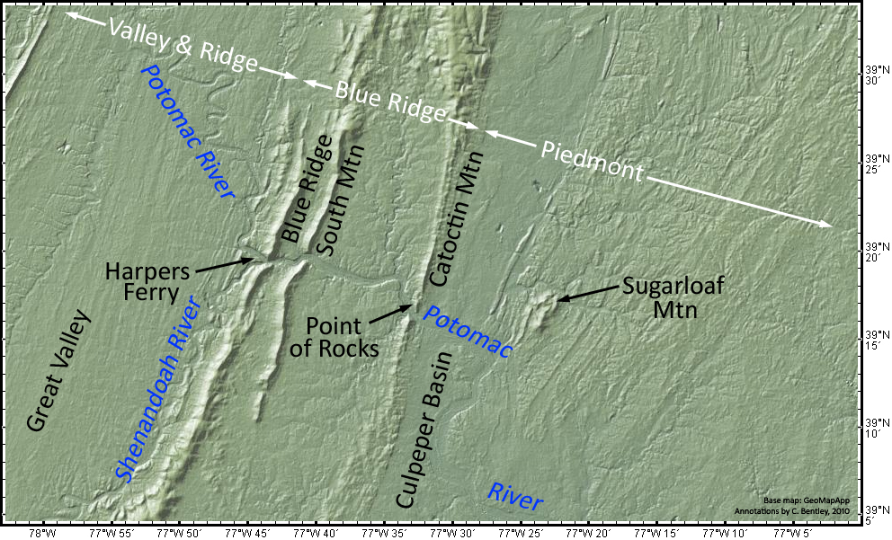
A larger version of the map can be viewed by clicking here.
On the far west, you can see the Valley & Ridge province, which ends at the Blue Ridge Thrust Fault. Then the Blue Ridge province runs east from the Blue Ridge itself to Catoctin Mountain. From there, you enter the Piedmont, including both the “crystalline” Piedmont (Paleozoic metamorphism of various ocean basin protoliths, plus infusions of granite) and the Culpeper Basin, a Triassic/Jurassic rift valley. The Potomac River cuts a series of three spectacular water gaps across the Blue Ridge province just west of Sugarloaf. Harpers Ferry, West Virginia, is located at the confluence of the Potomac and the Shenandoah Rivers by the westernmost of these water gaps, and the name for the easternmost one is “Point of Rocks.”
Here’s a look at a detail from the southeastern corner of the geologic map of the Buckeystown, MD quadrangle, by Scott Southworth and David Brezinski:
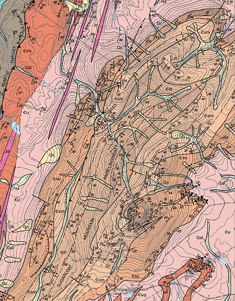
The map pattern shows a that the area around Sugarloaf Mountain is a doubly-plunging anticlinorium of Sugarloaf Mountain Quartzite [SMQ] and overlying (younger) Urbana Formation. Overall, it’s got that typical “Appalachian” northeast-southwest trend. Notice the thrust fault on the west side: a typical hanging wall anticline? The ridges, including the summit of Sugarloaf Mountain itself, are held up by the toughest quartzite. This overall “squashed donut” shape shows up pretty well in the physiographic map up at the top of this post.
Sugarloaf is quartzite (metamorphic), but you can clearly see the sand grains that composed its protolith (sedimentary). There’s also reports of cross-bedding, and so Chris asked me to take a look at a few structures to assess them with my point of view. I found a pervasive cleavage in the rock, far more than I would have suspected would be there. We did find bedding exposed as compositional/grain size layers in several locations, including on the summit. I also paid a lot of attention to the many quartz veins which cut the metasedimentary quartzite. These veins of “milky quartz” are often arranged in lovely en echelon series, like these tension gashes:
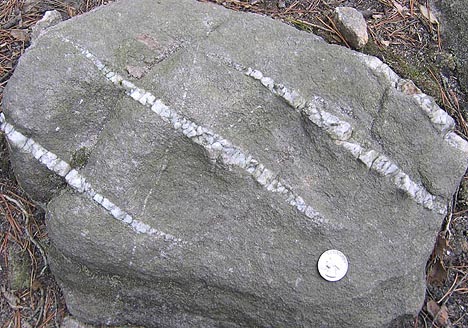
I took the above photo several years ago on a visit there, but it’s typical of the sorts of stuff we saw Sunday. The kinematic sense of this outcrop would be “top to the right.” Interestingly, none of the Sugarloaf outcrops show really deformed tension gashes (i.e., they’re not folded into Z or S shapes like those I showed you a few days ago).
What we really wanted to get a sense of, though, was which way was up in these rocks. We were in search of geopetal structures: primary sedimentary structures that indicate the “younging direction” of the beds. Graded beds can do this, though I didn’t see any unambiguous graded beds in the SMQ on Sunday’s trip. We wanted some cross-beds. We found some hummocky / swaley examples, looking approximately like this USGS photograph (black & white; hammer for scale) of an outcrop somewhere “north of the summit”:
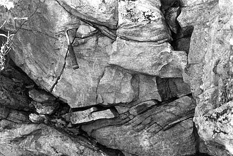 Image source: USGS
Ours wasn’t as beautiful as the one pictured above, but it was clearly hummocky cross-bedding, and it was right-side-up (in beds tilted at ~30°). Interestingly, the SMQ has been correlated by Southworth and Brezinski (2003) with the Weverton Formation of the Chilhowee Group, a rock unit exposed in the Blue Ridge. Just as the Weverton is overlain by the finer-grained Harpers Formation, so too is the SMQ overlain by a finer-grained unit, the Urbana Formation. Both are interpreted as metamorphosed continental margin deposits. The Urbana is mostly phyllite in the areas I’ve seen it (including phyllite that’s full of quartz grains, a first for me). The Urbana is well exposed in a creek-side outcrop north of Sugarloaf Mountain, and I took Chris there to show him the lovely intersection of bedding and cleavage.
Here is a weathered piece of the Urbana Formation that Chris collected there, looking at the plane of cleavage (ruler in background for scale):
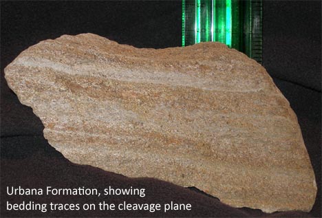 Image source: Christopher Khourey
You can see the bedding running ~horizontally across it, though the photo cannot convey the lovely phyllitic sheen that results from waggling these samples back and forth in good light. It’s pretty cool. In places, the transition from sandy to phyllitic is gradational, probably relict graded bedding.
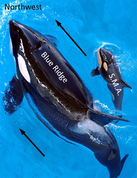
So, what does it mean if Southworth and Brezinski (2003) are correct in their correlation, and the Weverton and the SMQ are really the same rock layer, but in different provinces and at different metamorphic grades? Recall that the Blue Ridge province to the west is also a thrust-faulted anticlinorium, launched up and to the west by the Alleghanian Orogeny from an original position deeper in the crust and further towards the east. It’s a shard of the craton, snapped off and shoved bodily up and to the northwest. (In class, I often liken it to Joe Theismann’s leg: a compound fracture of the continental crust.) Might the Sugarloaf Mountain Anticlinorium [SMA] be a smaller version of the Blue Ridge pulling the same trick? It too is arched up and snapped off …but it would be a “Mini-Me” that’s only just surfacing, like a baby whale swimming above momma whale’s back…
We know that deeper down in the Blue Ridge stratigraphy, we find the Catoctin Formation, the Swift Run Formation, and the basement complex. If we drilled down through the crest of the SMA, would we find the same units (or more metamorphosed equivalents thereof)? It’s an intriguing thought…
 Callan Bentley is Associate Professor of Geology at Piedmont Virginia Community College in Charlottesville, Virginia. He is a Fellow of the Geological Society of America. For his work on this blog, the National Association of Geoscience Teachers recognized him with the James Shea Award. He has also won the Outstanding Faculty Award from the State Council on Higher Education in Virginia, and the Biggs Award for Excellence in Geoscience Teaching from the Geoscience Education Division of the Geological Society of America. In previous years, Callan served as a contributing editor at EARTH magazine, President of the Geological Society of Washington and President the Geo2YC division of NAGT.
Thank you! I have wondered about Sugarloaf for some time. My daughter goes to collegel in Westminster MD and we both see this mountain in the distance as we drive up there. We wonder if Sugarloaf, standing on its own is like Har Tavor (Mt. Tavor) near Afula in the lower Galliee region of Israel. Do they have some connection of how they were formed or why they are these single mountains in the middle of nowhere. Do you know anything about this, or could you help me to find out? My daughter lived and volunteered in the shadow of Har Tavor a few years ago.
Thanks for your comment. I don’t know about Mt. Tavor personally, but Sugarloaf’s geology isn’t unique: it’s basically a big blob of rock that is resistant to erosion. The surrounding rocks (Urbana Formation & other Piedmont rocks) are being etched away at faster rate than the stable quartz which is underneath Sugarloaf. It’s a “monadnock,” an erosional remnant that pokes up above the surrounding, more-easily-eroded landscape.
Thanks for the great posting on this – the area is familiar, though I didn’t remember anything specific about the geology.
Callan,
I’ve always wondered about the depostional environment of the SMQ and its relation to the Chilhowee Group and the Cambrian paleogeography of the area. With the cross-bedding, could the SMQ be a barrier island environment with the Urbana as a lagoon with washover fans and tidal deltas?
Within the Chilhowee, the Antietam Fm. is the one usually dubbed the “barrier island” complex. My imagination conjures a beach as the depositional setting for the Weverton, and the SMQ’s composition certainly looks beachy, but I don’t know if the cross-bedding backs that up or contradicts it. Perhaps someone with more sedimentary experience than me can pipe up to offer their perspective? I don’t know ANYTHING about interpreting sedimentary rocks with any degree of sophistication.
Callan,
Just went on the field trip to Sugarloaf Mtn. with Instructor Khorey. I’m lifting your pictures for the test questions. Thanks for your thoroughness and of course you will be duly credited for the work. Hope we can get together sometime.
Vince,
I’m glad I could be of use to your project!
CB
[…] recall that I detailed a trip to Sugarloaf on this blog back in March of last year. Well, on Saturday (March of this year), Lily and I […]
[…] Background geology of the Sugarloaf Mountain area. (March 2010) […]
This article is the clearest geological article I’ve ever read! Thank you so much.
Now that sugarloaf is unfortunately closed for hiking, can you please sign my petition to help keep it open?
I love your references. I love the whales. You are incredibly intelligent