
26 March 2010
Transect debrief 6: folding and faulting
Posted by Callan Bentley
Okay; we are nearing the end of our Transect saga. During the late Paleozoic, mountain building began anew, and deformed all the rocks we’ve mentioned so far. This final phase of Appalachian mountain-building is the Alleghanian Orogeny. It was caused by the collision of ancestral North America with the leading edge of Gondwana. At the latitude of Virginia, that means northwestern Africa (Morocco and/or Mauritania).
Whereas the first two pulses of Appalachian mountain building were relatively provincial affairs, this Alleghanian phase was a full-on continent-on-continent smackdown. The Himalaya (India colliding with Eurasia) would be a good modern analogue for the Pennsylvanian and Mississippian Appalachians.
When I was live-blogging the trip, I posted this photo of Judy Gap:

It was a bit hard to get it all into one measly iPhone frame (hence the tilted angle: those trees are in fact vertical!), but what you’re looking at here is the erosion-resistant Tuscarora Sandstone (Silurian in age; quartz-rich beach deposits) that outcrop as a ridge. However, here at Judy Gap, there are two ridges. What gives? This is where I was introduced to a new term that is apparently becoming a common phrase in the structural geology literature: contraction fault.
The story most Physical Geology students get about fault types is that tectonic extension causes normal faults, while tectonic compression causes reverse faults. Contraction faults are faults that display an apparent “normal” sense of motion, but were caused by a compressional tectonic regime. How the heck does that work, you may ask? Consider the following diagram:

So the deal with contraction folds is that they might start out “reverse” but are then rotated and tipped over as deformation proceeds. The former footwall becomes the new “hanging wall,” and the sense of motion is obscured by this new orientation. This means that they do represent contractional strain, but a freshman geology student is unlikely to spot it at first glance.
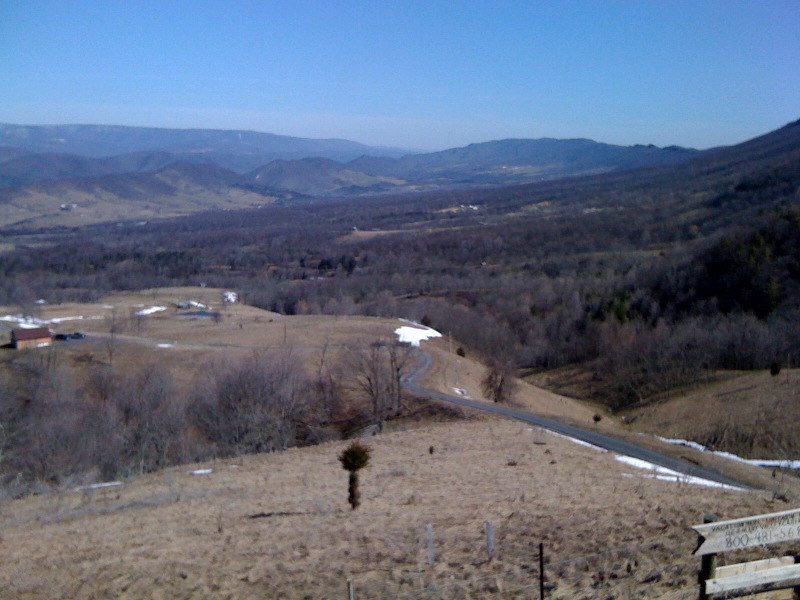
The Germany Valley to the east of Judy Gap is a big breached plunging anticline, as I attempted to show with this iPhone photo from the Germany Valley Overlook along Route 33:
It’s a bit easier to see if you jump up in the air 10 kilometers or so. Fortunately, that’s precisely why God created Google Earth:
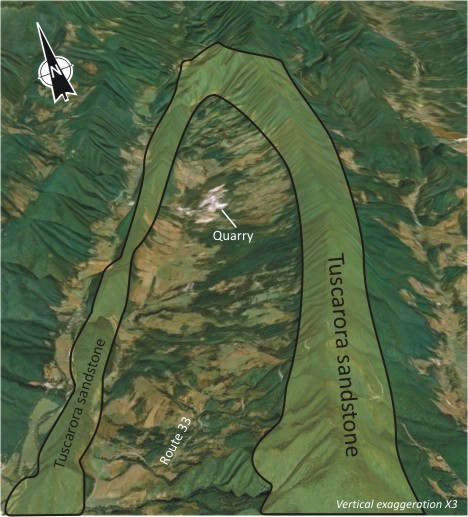
The valley is hemmed in by a big V-shaped fence of mountains, all held up by the Tuscarora. It’s tough stuff. During Alleghanian folding, the crest of the anticline was breached, and water was able to get inside and gut the weaker rocks. The quarry annotated in the photo is mining the same Cambrian and Ordovician carbonates seen in the Shenandoah Valley back in Virginia (Lincolnshire and Edinburg Formation equivalents). A pattern geologists have noted with eroded anticlines is that older rocks are exposed in the middle of the structure, with younger rocks flanking them along the sides.
So that’s a glimpse of the big picture of deformation in the Valley & Ridge, but we can also see cool deformation at smaller scales… Stay tuned…
 Callan Bentley is Associate Professor of Geology at Piedmont Virginia Community College in Charlottesville, Virginia. He is a Fellow of the Geological Society of America. For his work on this blog, the National Association of Geoscience Teachers recognized him with the James Shea Award. He has also won the Outstanding Faculty Award from the State Council on Higher Education in Virginia, and the Biggs Award for Excellence in Geoscience Teaching from the Geoscience Education Division of the Geological Society of America. In previous years, Callan served as a contributing editor at EARTH magazine, President of the Geological Society of Washington and President the Geo2YC division of NAGT.
tihs is cooooooooooooooooooollllllllllllllllllllllllll!!!!!!!!!!!!!!!!!!!!!!!!!!!!!!!!!!!!!!!!!!!!!!!!!!!!!!!!!!!!!!!!!!!!!!!!!!!!!!!!!!!!!!!!!!!!!!!!!!!!!!!!!!!!!!!!!!!!!!!!!!!!!!!!!!1