8 March 2010
When the Sturtian happened
Posted by Callan Bentley
![]() Last Friday, I spent the evening riding up to New York on a bus. To pass the time, I had my iPod and a new paper by Francis Macdonald and colleagues in Science. The paper examines the timing of one of the episodes of “Snowball Earth” glaciation. There’s some important new data in this paper, and it helps constrain the “Sturtian” glaciation in time.
Last Friday, I spent the evening riding up to New York on a bus. To pass the time, I had my iPod and a new paper by Francis Macdonald and colleagues in Science. The paper examines the timing of one of the episodes of “Snowball Earth” glaciation. There’s some important new data in this paper, and it helps constrain the “Sturtian” glaciation in time.
So here’s the deal with Precambrian glaciations: there have been several. Generally speaking, there was a big episode of glaciation around 2.5 Ga (“Ga” = billion years ago, for those new to geo-temporal argot, and “Ma” = million years ago). There were also a series of at least two, and maybe upwards of four episodes during the Neoproterozoic era (~700 Ma). These latter glaciations have been collectively dubbed the Snowball Earth glaciations for evidence which suggests that they were global in extent. The evidence was high-precision paleomagnetic signatures which suggest some of the glacial sediments were deposited within a few degrees of the equator. If the equator was frozen over, it follows that the rest of the planet was too, due to ice-albedo feedback. That’s kind of a big deal, and the Snowball Earth hypothesis has been a rich source of research inspiration over the past decade and a half.
Now, figuring out just when the Snowball Earth glaciers flowed is a bit tricky. You can’t directly date glacial sediments using radiogenic isotopes, as they will be composed of the pulverized remains of pre-existing rock bodies, and will yield older-than-actual ages. It would be cool to find volcanic layers within the sedimentary package, because we can date those, or to find igneous intrusives (like dikes) which cut across the glaciogenic sediments, because those too are worthy of dating. The younger of the two “main” Neoproterozoic glaciations is called the Marinoan glaciation, and it has been dated using methods like these in Namibia (635.5 ± 0.6 Ma) and China (between 636 ±4.9 Ma and 635.2 ± 0.2 Ma). Locations as farflung as China and Namibia and other Canada can be correlated with one another on the basis of stable isotope chemostratigraphy. Basically, the idea is that there are global fluctuations in the carbon (or sulfur, or oxygen, or whatever) isotope “signature” that gets locked in the sediments, due to whatever was happening in the world at that time (e.g., life gobbling up certain isotopes, or climatic shifts, or other “big picture” events). So the chemostratigraphy allows us to match up rock units of the same age, and the few places where we are lucky enough to get igneous units interacting with the sedimentary package allow us to pin the whole lot to a specific date.
Great… for the Marinoan.
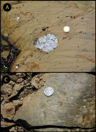
But an earlier “Snowball” episode, the Sturtian glaciation, has not been as precisely dated. Enter the Macdonald, et al. (2010) study. They report four new high-precision U/Pb dates from igneous rocks in the Ogilvie Mountains of northwestern Canada. Three of these are part of the Sturtian stratigraphic package, following the paradigm I outlined above. One, from a tuff unit, yielded a date of 717.43 ± 0.14 Ma, and another yielded a date of 716.47 ± 0.24 Ma: both of these were essentially right at the bottom of the Upper Mount Harper Group, which includes strata that are interpreted as belonging to the Sturtian glaciation on the basis of dropstones (A) and striated clasts (C) like these (from the supporting figure S2 for the paper):

They also found evidence of “grounded ice”: soft-sediment folds that resulted when (they interpret) the nose of the glacier shoved its way forward. So this wasn’t just a floating glacier above: the glacier was in the muck, suggesting it was right there at sea level.
This is a lucky find: a datable volcanic ash layer right at the base of a big stack of glacial sediments. It’s a major advance for understanding the Sturtian in its own right.
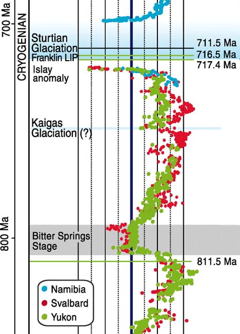
They also report a date of 811.51 ± 0.25 Ma for strata deeper down in the stack, right before a global isotopic ‘excursion’ (a big, distinctive leftward squiggle on the carbon chemostratigraphy plot) called the Bitter Springs isotopic stage. Here’s a detail from the paper’s Figure 2, showing how this new date integrates absolute time with the relative time illustrated by the isotopic curve:

That’s δ13C data plotted from three Neoproterozoic sections (in Namibia, Svalbard, and the Yukon). The thick central vertical black line is 0‰, with the left bound being -8‰ and the right bound being +8‰. The horizontal green lines show the new dates from this paper.
So all that is good, and a significant new batch of data for helping pin down the timing of these ancient glacial episodes. We’ve been able to date some Sturtian glacial units and a pre-Sturtian isotopic excursion.
The paper presents a fourth date, too: this is from a diabase sill that is part of the Franklin Large Igneous Province (LIP) exposed on Victoria Island, over 1000 km to the northeast of the Ogilvie Mountains (where the other three dates come from). The Franklin diabase gives a U/Pb age just like those from the Sturtian glacial sediments: 716.33 ± 0.54 Ma. But is this relevant, considering how different the rocks are, and how very far apart they are? Check out this map to see their lack of proximity, from the paper’s supporting figure S1:

Why would the paper’s authors bother with a rock unit so far away from the Ogilivie section? Well, the Franklin LIP is integral to the Snowball story on at least three fronts that I can think of. It ties this story together quite nicely, and I think that it is just as important as the Ogilvie data.
First, on a tectonic note, it’s a mafic unit that is associated with the breakup of Rodinia, a Proterozoic supercontinent. (Rodinia’s position on the paleo-equator is supposed to have sped up weathering of the continental crust and resulting CO2 drawdown, cooling the planet.) Second, it has paleomagnetic orientations which suggest it was emplaced within 10° of the magnetic equator. (This is important because it demonstrates that grounded ice was present within 10° of the equator at the time the Franklin LIP erupted… and due to ice-albedo feedback, it implies higher latitudes were frozen-over at that time, too.) Third, the Franklin LIP has been fingered as a possible culprit in causing Snowball Earth. This is because mafic igneous rocks suck CO2 out of the atmosphere when they are chemically weathered, producing carbonate rocks. The Franklin LIP has the potential to be a major driving force for the CO2 drawdown which initiated the Sturtian Snowball via global cooling. A big package of mafic rock delivered raw right to the tropical weathering belt could be sufficient to trigger an ice age, some workers have suggested. The Franklin LIP was in the right place at the right time: was it the culprit, or only an accomplice? Witness the way that the authors (properly) hedge their bet in their conclusion’s penultimate sentence:
…the synchrony among continental extension, the Franklin LIP, and the Sturtian glaciation is consistent with the hypothesis that the drawdown of CO2 via rifting and weathering of the low-latitude Franklin basalts could have produced a climate state that was more susceptible to glaciation.
_______________________________________________
Macdonald, F., Schmitz, M., Crowley, J., Roots, C., Jones, D., Maloof, A., Strauss, J., Cohen, P., Johnston, D., & Schrag, D. (2010). Calibrating the Cryogenian Science, 327 (5970), 1241-1243 DOI: 10.1126/science.1183325


 Callan Bentley is Associate Professor of Geology at Piedmont Virginia Community College in Charlottesville, Virginia. He is a Fellow of the Geological Society of America. For his work on this blog, the National Association of Geoscience Teachers recognized him with the James Shea Award. He has also won the Outstanding Faculty Award from the State Council on Higher Education in Virginia, and the Biggs Award for Excellence in Geoscience Teaching from the Geoscience Education Division of the Geological Society of America. In previous years, Callan served as a contributing editor at EARTH magazine, President of the Geological Society of Washington and President the Geo2YC division of NAGT.
Nice post. Of course, it is only when we get similarly good age constraints on all of the other Neoproterozoic glacial deposits that we’ll actually be able to establish that these correlations into single glacial episodes like the ‘Sturtian’ and ‘Marinoan’ are actually justified in the first place. There’s still a certain degree of circularity involved at the moment.
The Idaho and “type” Sturtian (South Australia) localites have internal and end dates in the 658-667 Ma range (Fanning and Link, ’04 onwards), making the Sturtian either very long, or diachronous. The best start Idaho date is 709 +/-5*, and there isn’t a good constraint for the S.A. start, as they are still looking for a better bentonite**
Did McDonald et al. manage to date anything above/ within/ close to the cap carbonate?
A 50 million-year-long glaciation and a diachronous glaciation are both big news, but in very different ways.
As an aside, in my exploration days I saw some amazing neoproterozoic morane drill core (not ours; their company was also processing at the NTGS core shed) from the Amadeus Basin from an exploration project. So the answer to all these questions is probably sitting in a shed in Perth somewhere, sequestered from inquiring minds by an impenetrable layer of confidentiality paperwork.
*Schmitz may have a more precise TIMS number for the Idaho stuff. His TIMS data (numbers reported above) are 10-30 times more precise than SHRIMP, but require better*** zircons.
** Actually ex-bentonites, as the Delamerian metamorphised them to biotite-rich felsics out there.
***fewer inclusions, no inherited cores, etc.
* By “numbers reported above” I meant in Callan’s excellent post, not the numbers in my comment.